1900s (20th Century) Maps of Crowther Cow Camp, New Mexico
Explore 9 historic maps of Crowther Cow Camp from the 1900s (20th Century). These maps offer a rare glimpse into what life looked like during the 1900s — showing old roads, neighborhoods, homes, and landmarks that have changed or disappeared over time.
Whether you're researching your family's past, planning a metal detecting trip, or studying how Crowther Cow Camp's landscape evolved across the 1900s, these high-resolution maps are a powerful tool for exploring the history of this region.
- Focus on a specific era: All maps on this page are from the 1900s, giving you a focused view of this time period.
- See what’s changed: Compare century-old streets, trails, and buildings to today's modern landscape using overlays and satellite layers.
- Research with precision: Use these maps for genealogy, historical research, land use analysis, or educational projects.
- View, download, or print: Maps are fully viewable online in high resolution, and can be downloaded or printed for your own records.
Start exploring Crowther Cow Camp's history through authentic maps from the 1900s. This is your window into the past.
Crowther Cow Camp, NM maps
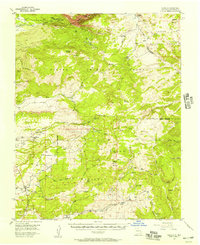
(9)- 1918 Map of Tusas
 1918 Tusas1918 Print · USGSThe high country of Northern New Mexico and the Colorado border is captured here during the First World War. Researchers can trace the Denver and Rio Grande RR through remote stations like Toltec or locate early settlements in the Tierra Amarilla Grant.
 - 1954 Map of Aztec, 1975 Print
 1954 Aztec1975 Print · USGSNorthern New Mexico and southern Colorado come alive in the mid-1950s, showing the high-country settlements and tribal lands of the San Juan Basin. Genealogists and historians can trace the path of the Denver & Rio Grande Western RR and locate communities like Abiquiu, Park View, and Lumberton.4 unique versions available
 - 1955 Map of Cebolla, 1957 Print
 1955 Cebolla1957 Print · USGSRio Arriba County’s high country in the mid-1950s reveals a landscape of cattle camps, mountain lodges, and isolated settlements. Genealogists and historians can trace the community at Cebolla, the San Antonio Ch, and seasonal outposts like Johnson Cow Camp.3 unique versions available
 - 1958 Map of Aztec
 1958 Aztec1958 Print · USGSNorthern New Mexico and the southern Colorado border are captured here during the mid-fifties, showing the rugged intersection of national forests and tribal lands. Researchers can trace the Denver and Rio Grande Western rail line and locate remote outposts like Blanco Trading Post or Sargent Ranch.
 - 1962 Map of Aztec
 1962 Aztec1962 Print · USGSNorthwestern New Mexico in the early sixties showcases a landscape defined by the arrival of the Navajo Reservoir and the high-altitude timber of the Carson National Forest. Trace the path of the Denver & Rio Grande Western RR or locate historic settlements like Tierra Amarilla and Gobernador.
 - 1965 Map of Aztec
 1965 Aztec1965 Print · USGSNorthern New Mexico and southern Colorado come alive in the mid-sixties, from the San Juan Basin to the high Jemez Mountains. Trace the narrow-gauge Denver & Rio Grande Western RR through Monero or locate old outposts like Blanco Trading Post.
 - 1981 Map of Chama, 1982 Print
 1981 Chama1982 Print · USGSNorthern New Mexico's high-country rail corridors and historic land grants are mapped here as they appeared in the early eighties. Genealogists and historians can trace traditional settlements like Los Ojos and Tierra Amarilla or follow the narrow-gauge Cumbres and Toltec Scenic Railroad.
 - 1983 Map of East Gavilan Canyon
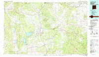
 1983 East Gavilan Canyon1983 Print · USGSRio Arriba County in the early eighties was a landscape of high canyons and historic land grants. Genealogists and historians can trace the precise Tierra Amarilla Grant Bdy and the drainage of Rio Vallecitos and Jawbone Mountain.
 - 1995 Map of East Gavilan Canyon, 1998 Print
 1995 East Gavilan Canyon1998 Print · USGSNorthern New Mexico during the mid-nineties shows a landscape defined by traditional land grants and seasonal ranching. Local historians can trace high-country activity through the Peterson Cow Camp, the Tierra Amarilla Grant, and the slopes of Jawbone Mountain.
End of results
Showing maps 1-9 of 9
Top cities near Crowther Cow Camp
Frequently asked questions
- What are the different types of historical maps available for Crowther Cow Camp?
- What is the oldest map of Crowther Cow Camp?
- Where can I purchase historical maps of Crowther Cow Camp for my home or office?
- Where can I download high-res historical maps of Crowther Cow Camp?
- Are there historical topographic maps available for Crowther Cow Camp?
- Is there historical aerial imagery available for Crowther Cow Camp?
- Where are historical maps of Crowther Cow Camp sourced from?