1980s Maps of Archuleta, New Mexico
Explore 2 historic maps of Archuleta from the 1980s. These maps offer a rare glimpse into what life looked like during the 1980s — showing old roads, neighborhoods, homes, and landmarks that have changed or disappeared over time.
Whether you're researching your family's past, planning a metal detecting trip, or studying how Archuleta's landscape evolved across the 1980s, these high-resolution maps are a powerful tool for exploring the history of this region.
- Focus on a specific era: All maps on this page are from the 1980s, giving you a focused view of this time period.
- See what’s changed: Compare century-old streets, trails, and buildings to today's modern landscape using overlays and satellite layers.
- Research with precision: Use these maps for genealogy, historical research, land use analysis, or educational projects.
- View, download, or print: Maps are fully viewable online in high resolution, and can be downloaded or printed for your own records.
Start exploring Archuleta's history through authentic maps from the 1980s. This is your window into the past.
Archuleta, NM maps
(2)- 1980 Map of Navajo Reservoir, 1981 Print
 1980 Navajo Reservoir1981 Print · USGSThe high desert and river valleys of Rio Arriba and San Juan counties are captured here in the early eighties. Genealogists and local historians can trace the development of Aztec and Bloomfield or locate family sites along Gubernador Canyon and the Animas River.
 - 1985 Map of Archuleta
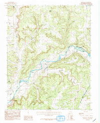 1985 Archuleta1985 Print · USGSNorthwestern New Mexico's river-fed canyons and mesa lands are captured here in the mid-1980s. Local researchers can trace old irrigation routes along Citizens Ditch and locate family-named landmarks like Martinez and Melquiadis Point.
End of results
Showing maps 1-2 of 2
Top cities near Archuleta
Frequently asked questions
- What are the different types of historical maps available for Archuleta?
- What is the oldest map of Archuleta?
- Where can I purchase historical maps of Archuleta for my home or office?
- Where can I download high-res historical maps of Archuleta?
- Are there historical topographic maps available for Archuleta?
- Is there historical aerial imagery available for Archuleta?
- Where are historical maps of Archuleta sourced from?