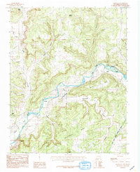
1985 Map of Archuleta
USGS Topo · Published 1985About this map
The San Juan River carves a deep path through northwestern New Mexico, anchoring a landscape where river-valley life meets the high desert mesas of San Juan County. Small settlements like Archuleta, Martinez, and Gobernador sit alongside complex irrigation systems, including the Citizens Ditch and the substantial Navajo Indian Irrigation Project Main Canal. These water-management features highlight the essential relationship between the arid terrain and the agricultural viability of the region during the mid-1980s.
Find a feature on this map
24 named features on this map. Tap any name to fly to it.
Don’t see what you’re looking for? This feature index may not catch every label — zoom into the map to look around manually.
Map Details
Editions of this 1985 Archuleta Map
This is the sole edition of this map. No revisions or reprints were ever made.
Other maps of this area

1889 · Largo
USGS Topo · 1:250,000

1895 · Largo
USGS Topo · 1:250,000

1954 · Pine River
USGS Topo · 1:24,000
1954 · Burnt Mesa
USGS Topo · 1:24,000

1954 · Aztec
USGS Topo · 1:250,000

1958 · Aztec
USGS Topo · 1:250,000

1959 · Gould Pass
USGS Topo · 1:62,500

1959 · Aztec
USGS Topo · 1:62,500

1959 · Navajo Dam
USGS Topo · 1:62,500

1960 · Bloomfield
USGS Topo · 1:62,500