1980s Maps of Aztec, New Mexico
Explore 3 historic maps of Aztec from the 1980s. These maps offer a rare glimpse into what life looked like during the 1980s — showing old roads, neighborhoods, homes, and landmarks that have changed or disappeared over time.
Whether you're researching your family's past, planning a metal detecting trip, or studying how Aztec's landscape evolved across the 1980s, these high-resolution maps are a powerful tool for exploring the history of this region.
- Focus on a specific era: All maps on this page are from the 1980s, giving you a focused view of this time period.
- See what’s changed: Compare century-old streets, trails, and buildings to today's modern landscape using overlays and satellite layers.
- Research with precision: Use these maps for genealogy, historical research, land use analysis, or educational projects.
- View, download, or print: Maps are fully viewable online in high resolution, and can be downloaded or printed for your own records.
Start exploring Aztec's history through authentic maps from the 1980s. This is your window into the past.
Aztec, NM maps
(3)- 1980 Map of Farmington, 1981 Print
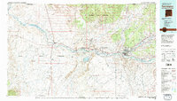 1980 Farmington1981 Print · USGSIn the San Juan Basin during the early 1980s, the energy economy was rapidly transforming the landscape around Farmington and Shiprock. Genealogists and historians can trace the growth of river towns like Kirtland or locate specific sites like the Navajo Mine and Aztec Ruins.2 unique versions available
 - 1980 Map of Navajo Reservoir, 1981 Print
 1980 Navajo Reservoir1981 Print · USGSThe high desert and river valleys of Rio Arriba and San Juan counties are captured here in the early eighties. Genealogists and local historians can trace the development of Aztec and Bloomfield or locate family sites along Gubernador Canyon and the Animas River.
 - 1985 Map of Aztec
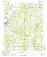 1985 Aztec1985 Print · USGSIn the mid-eighties, the high desert around the Animas River was a landscape of ancestral history and modern energy production. Researchers can trace the Old Railroad Grade, locate the Aztec Ruins National Monument, and explore the rugged drainages of Williams Arroyo and Potter Canyon.
End of results
Showing maps 1-3 of 3
Top cities near Aztec
- Farmington historical maps
- Bloomfield historical maps
- Aztec historical maps
- Eastern Navajo Agency historical maps
- Flora Vista historical maps
Top neighborhoods of Aztec
Frequently asked questions
- What are the different types of historical maps available for Aztec?
- What is the oldest map of Aztec?
- Where can I purchase historical maps of Aztec for my home or office?
- Where can I download high-res historical maps of Aztec?
- Are there historical topographic maps available for Aztec?
- Is there historical aerial imagery available for Aztec?
- Where are historical maps of Aztec sourced from?