1900s (20th Century) Maps of Tejon, New Mexico
Explore 9 historic maps of Tejon from the 1900s (20th Century). These maps offer a rare glimpse into what life looked like during the 1900s — showing old roads, neighborhoods, homes, and landmarks that have changed or disappeared over time.
Whether you're researching your family's past, planning a metal detecting trip, or studying how Tejon's landscape evolved across the 1900s, these high-resolution maps are a powerful tool for exploring the history of this region.
- Focus on a specific era: All maps on this page are from the 1900s, giving you a focused view of this time period.
- See what’s changed: Compare century-old streets, trails, and buildings to today's modern landscape using overlays and satellite layers.
- Research with precision: Use these maps for genealogy, historical research, land use analysis, or educational projects.
- View, download, or print: Maps are fully viewable online in high resolution, and can be downloaded or printed for your own records.
Start exploring Tejon's history through authentic maps from the 1900s. This is your window into the past.
Tejon, NM maps
(9)- 1954 Map of Hagan, 1955 Print
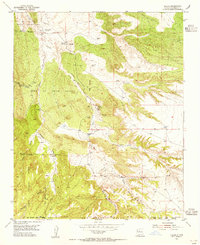 1954 Hagan1955 Print · USGSThe Sandoval County high desert in the mid-fifties reveals a landscape of fading mining towns and deep-rooted Spanish land grants. Researchers can trace the remnants of the local coal industry through the Old Railroad Grade and sites like Hagan and Tejon.3 unique versions available
 - 1954 Map of San Felipe Pueblo, 1958 Print
 1954 San Felipe Pueblo1958 Print · USGSSandoval County at the dawn of the atomic age shows a landscape of deep ancestry and industrial change. Researchers can trace the river life at San Felipe Pueblo or locate vanished mining sites near Hagan (Ghost Town) and Tejon (Ghost Town).2 unique versions available
 - 1958 Map of Albuquerque
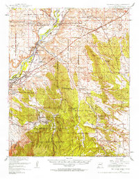
 1958 Albuquerque1958 Print · USGSAlbuquerque and the surrounding high desert are captured here during a period of massive federal expansion and postwar growth. Researchers can trace the development of Kirtland Air Force Base, find ancestral homes in Pueblo de Santa Ana, or locate industrial sites like the Jackpile Mine.
 - 1962 Map of Albuquerque
 1962 Albuquerque1962 Print · USGSAlbuquerque and the surrounding high desert are captured here in the early 1960s during a period of intense mineral and military growth. Genealogists and historians can locate early schools like the Pueblo Pintado School, major industrial sites like the Jackpile Mine, and the sprawling Kirtland Air Force Base.
 - 1963 Map of Albuquerque, 1965 Print
 1963 Albuquerque1965 Print · USGSMid-century New Mexico unfolds across this map, showcasing the intersection of ancient pueblos, modern military bases, and historic mining districts. Trace family roots and local history through the Ortiz Mine, Seven Lakes Trading Post, and Alameda.3 unique versions available
 - 1975 Map of Hagan, 1986 Print
 1975 Hagan1986 Print · USGSSandoval County in the mid-1970s reveals a landscape defined by old land grants and the remnants of early mining and rail. Researchers can trace the Old Railroad Grade, locate the Tejon Cemetery, and find Tonque Pueblo (Ruins).
 - 1978 Map of Albuquerque, 1986 Print
 1978 Albuquerque1986 Print · USGSGreater Albuquerque and the Rio Grande valley are captured here during a period of significant suburban expansion in the late seventies. Researchers can trace the early Subdivision Road Pattern near Rio Rancho and the historic footprints of Santa Ana Pueblo and Bernalillo.
 - 1983 Map of Albuquerque, 1984 Print
 1983 Albuquerque1984 Print · USGSCentral New Mexico in the early eighties shows a landscape where ancient pueblos and modern aerospace hubs meet. Trace the routes of the Atchison Topeka and Santa Fe RR or locate landmarks like Kirtland Air Force Base, Madrid, and the Sandia Mountains.
 - 1990 Map of Hagan, 1996 Print
 1990 Hagan1996 Print · USGSSandoval County's high desert is captured here in the 1990s, revealing a landscape of ancient sites and early industrial remnants. Local historians can trace the Old RR Grade and locate historical settlements like Hagan, Tejon, and the Tonque Pueblo (Site).
End of results
Showing maps 1-9 of 9
Top cities near Tejon
- Albuquerque historical maps
- Rio Rancho historical maps
- Bernalillo historical maps
- Corrales historical maps
- Edgewood historical maps
- Cedar Crest historical maps
See more
Frequently asked questions
- What are the different types of historical maps available for Tejon?
- What is the oldest map of Tejon?
- Where can I purchase historical maps of Tejon for my home or office?
- Where can I download high-res historical maps of Tejon?
- Are there historical topographic maps available for Tejon?
- Is there historical aerial imagery available for Tejon?
- Where are historical maps of Tejon sourced from?