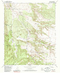
1975 Map of Hagan
USGS Topo · Published 1986About this map
Tonque Pueblo (Ruins) sits at the northern edge of this landscape, marking a historical layer of habitation along the Arroyo Tonque. The map captures an era where industry and cattle ranching defined the terrain of the Town of Tejon Grant, evidenced by the scattered Coal Mines and the presence of the Diamond Tail Ranch. The transportation network is dominated by historical infrastructure, specifically the Old Railroad Grade and the San Pedro Railroad Grade, which trace the path of earlier resource extraction through the canyons. Notable local landmarks for genealogists include the Tejon Cemetery and the Uña de Gato (Site) Cem, alongside small settlements like Hagan and Tejon. The drainage systems, including Arroyo Tejon and San Pedro Creek, carve through the complex topography that transitions into the Cibola National Forest.
Find a feature on this map
36 named features on this map. Tap any name to fly to it.
Don’t see what you’re looking for? This feature index may not catch every label — zoom into the map to look around manually.
Map Details
Editions of this 1975 Hagan Map
This is the sole edition of this map. No revisions or reprints were ever made.
Other maps of this area

1892 · San Pedro
USGS Topo · 1:125,000

1954 · Sandia Crest
USGS Topo · 1:24,000

1954 · San Felipe Pueblo
USGS Topo · 1:24,000

1954 · Placitas
USGS Topo · 1:24,000

1954 · Sandia Park
USGS Topo · 1:24,000

1954 · San Pedro
USGS Topo · 1:24,000

1954 · San Felipe Pueblo NE
USGS Topo · 1:24,000

1954 · Hagan
USGS Topo · 1:24,000

1954 · San Felipe Pueblo
USGS Topo · 1:62,500

1956 · Edgewood
USGS Topo · 1:62,500