1890s Maps of Allegany County, New York
Explore 2 historic maps of Allegany County from the 1890s. These maps offer a rare glimpse into what life looked like during the 1890s — showing old roads, neighborhoods, homes, and landmarks that have changed or disappeared over time.
Whether you're researching your family's past, planning a metal detecting trip, or studying how Allegany County's landscape evolved across the 1890s, these high-resolution maps are a powerful tool for exploring the history of this region.
- Focus on a specific era: All maps on this page are from the 1890s, giving you a focused view of this time period.
- See what’s changed: Compare century-old streets, trails, and buildings to today's modern landscape using overlays and satellite layers.
- Research with precision: Use these maps for genealogy, historical research, land use analysis, or educational projects.
- View, download, or print: Maps are fully viewable online in high resolution, and can be downloaded or printed for your own records.
Start exploring Allegany County's history through authentic maps from the 1890s. This is your window into the past.
Allegany County, NY maps
(2)- 1898 Map of Olean
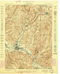 1898 Olean1898 Print · USGSCattaraugus County is shown here at the peak of its rail-and-river era, centered on the major industrial junction at Olean. Genealogists and collectors can trace the sprawling network of the Penna. R.R. and locate vanished local landmarks like the Oil Tanks or the distinct formation at Rock City.5 unique versions available
 - 1899 Map of Gaines, 1960 Print
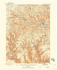 1899 Gaines1960 Print · USGSPotter and Tioga Counties are seen here at the end of the nineteenth century, as the logging and rail industries reached into every deep hollow. Genealogists and historians can trace family lands near Harrison Valley, Sabinsville, and the remote Loucks Mills.2 unique versions available
End of results
Showing maps 1-2 of 2
Top cities of Allegany County
- Wellsville historical maps
- Alfred historical maps
- Cuba historical maps
- Caneadea historical maps
- Amity historical maps
- Hume historical maps
See more
Frequently asked questions
- What are the different types of historical maps available for Allegany County?
- What is the oldest map of Allegany County?
- Where can I purchase historical maps of Allegany County for my home or office?
- Where can I download high-res historical maps of Allegany County?
- Are there historical topographic maps available for Allegany County?
- Is there historical aerial imagery available for Allegany County?
- Where are historical maps of Allegany County sourced from?