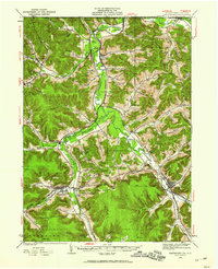
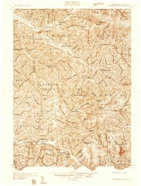
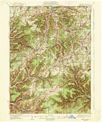
Old Maps of Allegany County, New York for Hiking & Exploration
Hike through history with 247 historic maps of Allegany County. Explore old trails, ghost towns, and forgotten backroads — perfect for outdoor adventurers and local explorers.
- Rediscover forgotten places: Map out old mining camps, roads, and footpaths that no longer exist on modern maps.
- Layer with modern tools: Combine with LiDAR or satellite views to plan hikes through historical terrain.
- Made for exploration: Popular among hikers, overlanders, and local history lovers.
Use these maps to find adventure and explore the hidden past of Allegany County.
Allegany County, NY maps
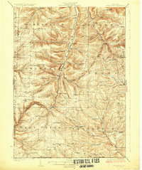
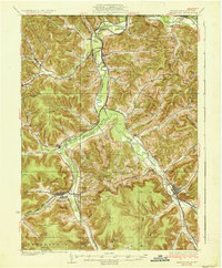
(247)- 1898 Map of Olean
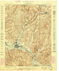 1898 Olean1898 Print · USGSCattaraugus County is shown here at the peak of its rail-and-river era, centered on the major industrial junction at Olean. Genealogists and collectors can trace the sprawling network of the Penna. R.R. and locate vanished local landmarks like the Oil Tanks or the distinct formation at Rock City.5 unique versions available
 - 1899 Map of Gaines, 1960 Print
 1899 Gaines1960 Print · USGSPotter and Tioga Counties are seen here at the end of the nineteenth century, as the logging and rail industries reached into every deep hollow. Genealogists and historians can trace family lands near Harrison Valley, Sabinsville, and the remote Loucks Mills.2 unique versions available
 - 1900 Map of Gaines
 1900 Gaines1900 Print · USGSThe Cowanesque River valley at the turn of the century shows a landscape defined by new rail lines and remote timbering settlements. Genealogists can trace family holdings near Sunderlinville, Harrison Valley, and the rural crossroads of Mixtown and Lansing.5 unique versions available
 - 1905 Map of Portage
 1905 Portage1905 Print · USGSWyoming County at the turn of the century shows a landscape defined by the deep gorge of the Genesee River and a busy rail network. Genealogists can trace family names at Halls Corners, explore the Silver Lake Assembly, or locate the mills and stations at Rock Glen and Portageville.6 unique versions available
 - 1905 Map of Nunda
 1905 Nunda1905 Print · USGSLivingston County rail and river life are captured here at the turn of the century, centered on the Genesee River valley. Trace the vanished streets of St Helena, locate the Sonyea P O Craig Colony, and follow the complex rail junctions at Mount Morris.6 unique versions available
 - 1906 Map of Angelica
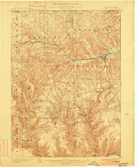
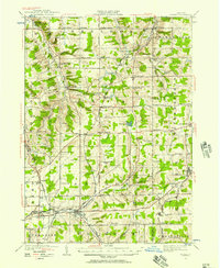
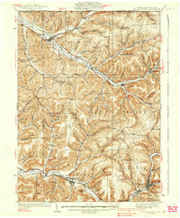
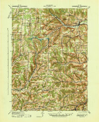
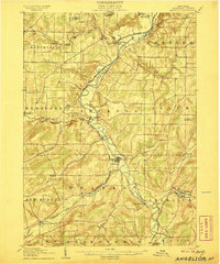 1906 Angelica1906 Print · USGSAllegany County thrived as a railroad and river corridor during the early twentieth century. Researchers can trace the path of the Pennsylvania R R and find long-established villages like Angelica, Fillmore, and the river crossing at Belfast.6 unique versions available
 - 1915 Map of Hornell, 1962 Print
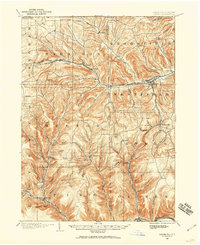
 1915 Hornell1962 Print · USGSSteuben County was a bustling rail hub when this survey was conducted, featuring a dense network of steam and electric lines. Genealogists can locate dozens of country schoolhouses like Babcock School and Eells School, alongside rural settlements such as Arkport and Haskinville.
 - 1916 Map of Canaseraga
 1916 Canaseraga1916 Print · USGSAllegany and Livingston counties appear in the decade before the Great War, during the peak of the local rail era. Genealogists can locate dozens of numbered schoolhouses and family-named landmarks like Whitney Crossings, Karrdale, and the Jersey Hill School.4 unique versions available
 - 1918 Map of Hornell
 1918 Hornell1918 Print · USGSThe rail-and-river corridor of Steuben County comes alive in the years following the Great War. Genealogists can trace family footprints across dozens of country school sites like Dutch Street School and rail hubs from Arkport to Canisteo.6 unique versions available
 - 1923 Map of Arcade, 1957 Print
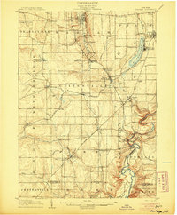
 1923 Arcade1957 Print · USGSWyoming County is captured in the early 1920s, showing a landscape defined by dairy farming and the vital rail connections of the Arcade and Attica. Genealogists can trace family names at Hicks Corners and Toziers Corners, or locate rural landmarks like Klein School and Java Lake.2 unique versions available
 - 1924 Map of Franklinville
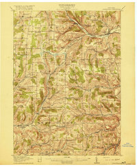
 1924 Franklinville1924 Print · USGSCattaraugus County agricultural life and rail commerce are documented here in the mid-twenties. Genealogists and local historians can trace family roots through numerous rural landmarks like Siloam Church, County Line Cem, and the Checkered School.3 unique versions available
 - 1925 Map of Belmont
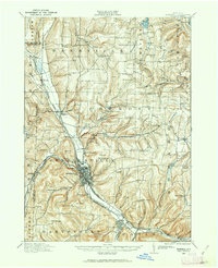
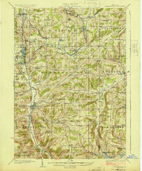
 1925 Belmont1925 Print · USGSAllegany County hills and river valleys are shown in the mid-twenties, centered on the railroad hubs and rural townships. Trace the tracks of the Erie RR and Shawmut RR past local landmarks like School No 5 and Richburg.4 unique versions available
 - 1925 Map of Arcade
 1925 Arcade1925 Print · USGSWestern New York’s rural landscape is captured here in the mid-1920s, a time when one-room schoolhouses and family-named crossroads still defined the countryside. Genealogists can trace property vicinities near Java Village, locate the elusive Cheery Tavern, or follow the path of the Arcade and Attica railroad.4 unique versions available
 - 1926 Map of Wellsville
 1926 Wellsville1926 Print · USGSAllegany County's southern reaches appear here in the mid-1920s as a hub of river-valley commerce and upland farming. Genealogists can trace early homesteads near Irish Settlement, Stannards Corners, and numerous rural schools like Ford Brook School.5 unique versions available
 - 1926 Map of Greenwood
 1926 Greenwood1926 Print · USGSSteuben County during the mid-1920s reveals a landscape defined by the deep valleys of Bennetts Creek and the hills of West Union. Genealogists and historians can trace numerous rural schoolhouses and vanished hamlets like Rough and Ready and Barney Mills.4 unique versions available
 - 1932 Map of Genesee, 1961 Print
 1932 Genesee1961 Print · USGSNorthern Pennsylvania’s high plateau is captured here in the early thirties, showing the transition from timber-hauling rail lines to mountain highways. Genealogists can locate family names at Andrews Settlement, the Sweden Hill Cem, or the Ice Mine.
 - 1933 Map of Smethport, 1960 Print
 1933 Smethport1960 Print · USGSNorthern Pennsylvania’s river valleys were centers of industry and transit in the early 1930s as rail lines followed the winding water gaps. Genealogists can trace family roots through numerous valley schoolhouses like Bush Hill Sch and rural settlements including Duke Center and Turtlepoint.
 - 1934 Map of Coudersport
 1934 Coudersport1934 Print · USGSPotter and McKean Counties appear here in the mid-1930s, showing a landscape of deep hollows and river-valley rail towns. Genealogists can trace family names through dozens of rural landmarks like Sartwell Cr Ch, Knowlton Station, and Shinglehouse.3 unique versions available
 - 1937 Map of Genesee
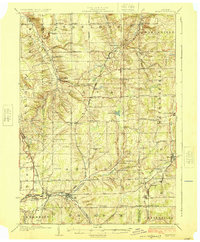
 1937 Genesee1937 Print · USGSPotter County’s high plateau is captured in the 1930s when the headwaters of the Allegheny River and Genesee River met a complex network of mountain railroads. Genealogists can locate family landmarks like Sweden Hill Cem, the Ice Mine, and numerous district schools including Judd Sch.3 unique versions available
 - 1937 Map of Smethport
 1937 Smethport1937 Print · USGSMcKean County's river valleys and oil-country settlements are captured here in the mid-1930s as the regional rail network still connected remote hollows. Genealogists and historians can trace the exact locations of local schools like Newell Creek Sch, old family landmarks such as Devils Den, and the rural layout of Smethport.3 unique versions available
 - 1938 Map of Coudersport
 1938 Coudersport1938 Print · USGSNorthern Pennsylvania during the mid-1930s was a landscape of deep hollows and river-bottom settlements tied to the Allegheny and Oswayo. Researchers can trace the placement of rural landmarks like Crandall Hill Fire Tower, Sartwell Creek Ch, and the Plank Road Sch.3 unique versions available
 - 1938 Map of Olean, 1955 Print
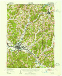 1938 Olean1955 Print · USGSOlean and the Allegheny River valley are shown here just before the mid-century, defined by a dense network of Pennsylvania and Erie rail lines. Local historians can trace the development of Westons Mills and the industrial layout near North Olean or locate the Oil Spring Indian Reservation.3 unique versions available
 - 1939 Map of Belmont, 1961 Print
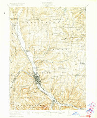
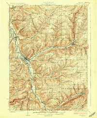
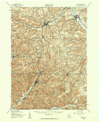 1939 Belmont1961 Print · USGSAllegany County highlands at the end of the 1930s show a landscape shaped by the Genesee River and the legacy of the Pittsburg Shawmut and Northern RR. Genealogists can trace family school districts like Carnahan Sch or explore the early footprints of Richburg and Little Genesee.2 unique versions available
 - 1940 Map of Canaseraga
 1940 Canaseraga1940 Print · USGSAllegany County's rural township structure is captured here just before the mid-century, showing a landscape tied together by local district schools and the Erie railroad. Researchers can locate early homesteads near Brewer Corners, trace the rail sidings at Garwoods Sta, or find ancestral landmarks like the County House and Jersey Hill School.2 unique versions available
 - 1941 Map of Angelica
 1941 Angelica1941 Print · USGSAllegany County during the early years of the Second World War was defined by its river-valley rail lines and high-country hamlets. Researchers can trace the legacy of Houghton College, the impact of the Caneadea Dam, and find vanished crossroads like Aristotle and McGrawville.
Showing maps 1-25 of 247
Top cities of Allegany County
- Wellsville historical maps
- Alfred historical maps
- Cuba historical maps
- Caneadea historical maps
- Amity historical maps
- Hume historical maps
See more
Frequently asked questions
- What are the different types of historical maps available for Allegany County?
- What is the oldest map of Allegany County?
- Where can I purchase historical maps of Allegany County for my home or office?
- Where can I download high-res historical maps of Allegany County?
- Are there historical topographic maps available for Allegany County?
- Is there historical aerial imagery available for Allegany County?
- Where are historical maps of Allegany County sourced from?