1940s Maps of Granger, New York
Explore 6 historic maps of Granger from the 1940s. These maps offer a rare glimpse into what life looked like during the 1940s — showing old roads, neighborhoods, homes, and landmarks that have changed or disappeared over time.
Whether you're researching your family's past, planning a metal detecting trip, or studying how Granger's landscape evolved across the 1940s, these high-resolution maps are a powerful tool for exploring the history of this region.
- Focus on a specific era: All maps on this page are from the 1940s, giving you a focused view of this time period.
- See what’s changed: Compare century-old streets, trails, and buildings to today's modern landscape using overlays and satellite layers.
- Research with precision: Use these maps for genealogy, historical research, land use analysis, or educational projects.
- View, download, or print: Maps are fully viewable online in high resolution, and can be downloaded or printed for your own records.
Start exploring Granger's history through authentic maps from the 1940s. This is your window into the past.
Granger, NY maps
(6)- 1940 Map of Canaseraga
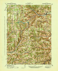 1940 Canaseraga1940 Print · USGSAllegany County's rural township structure is captured here just before the mid-century, showing a landscape tied together by local district schools and the Erie railroad. Researchers can locate early homesteads near Brewer Corners, trace the rail sidings at Garwoods Sta, or find ancestral landmarks like the County House and Jersey Hill School.2 unique versions available
 - 1941 Map of Angelica
 1941 Angelica1941 Print · USGSAllegany County during the early years of the Second World War was defined by its river-valley rail lines and high-country hamlets. Researchers can trace the legacy of Houghton College, the impact of the Caneadea Dam, and find vanished crossroads like Aristotle and McGrawville.
 - 1943 Map of Nunda, 1960 Print
 1943 Nunda1960 Print · USGSLivingston County's agricultural valleys and steep gorges are captured here during the early 1940s. Genealogists and rail historians can trace the routes of the Pennsylvania and Erie lines through Dalton, Nunda, and the rural crossing at Nunda Junction.
 - 1943 Map of Portageville, 1960 Print
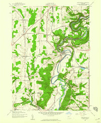 1943 Portageville1960 Print · USGSThe Genesee River valley in the early 1940s shows a landscape defined by dramatic waterfalls and the vital corridors of the Erie and Pennsylvania railroads. Trace the industrial footprints of Mills Mills and Bluestone or locate family roots near Portageville.
 - 1944 Map of Nunda
 1944 Nunda1944 Print · USGSLivingston and Allegany counties are shown here during the mid-forties, capturing the rural rail-and-river network of the Genesee Valley. Researchers can trace historic family-named routes and vanished sidings at Nunda Junction, Hunts Hollow, and Dalton.
 - 1944 Map of Portageville
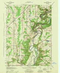 1944 Portageville1944 Print · USGSThe Genesee River valley in the mid-1940s is defined by its dramatic falls and the intersection of rail lines like the Erie and Pennsylvania. Genealogists and historians can trace the rural communities of Portageville, Wiscoy, and Mills during this wartime era.
End of results
Showing maps 1-6 of 6
Top cities near Granger
- Warsaw historical maps
- Alfred historical maps
- Mount Morris historical maps
- Alfred historical maps
- Cuba historical maps
- Castile historical maps
See more
Top neighborhoods of Granger
Frequently asked questions
- What are the different types of historical maps available for Granger?
- What is the oldest map of Granger?
- Where can I purchase historical maps of Granger for my home or office?
- Where can I download high-res historical maps of Granger?
- Are there historical topographic maps available for Granger?
- Is there historical aerial imagery available for Granger?
- Where are historical maps of Granger sourced from?