
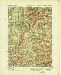
1940 Map of Canaseraga
USGS Topo · Published 1940About this map
Canaseraga serves as a primary rail and social hub in the northeast corner of this 1940 revision, where the Erie and P S & N railroads converge near Whitney Crossings. The landscape is defined by a dense network of district schools, ranging from New Michigan School to the uniquely named Thorntree Sch, illustrating the dispersed rural population of the era. Settlement patterns follow the valleys of Canaseraga Creek and the Canisteo River, with small hamlets like Swain and Garwoods Sta supporting the steam-era transit lines. In the south, Alfred Station and the neighborhood of Tinkertown sit near the educational center of Alfred. The presence of the County House in the west and a Gas Spring near the center of the quadrangle point to specific local landmarks that have served as community reference points for generations of Allegany County residents.
Find a feature on this map
58 named features on this map. Tap any name to fly to it.
Don’t see what you’re looking for? This feature index may not catch every label — zoom into the map to look around manually.
Map Details
Editions of this 1940 Canaseraga Map
2 editions found
Other maps of this area

1902 · Wayland
USGS Topo · 1:62,500

1904 · Wayland
USGS Topo · 1:62,500

1905 · Portage
USGS Topo · 1:62,500

1905 · Nunda
USGS Topo · 1:62,500

1906 · Angelica
USGS Topo · 1:62,500

1915 · Hornell
USGS Topo · 1:62,500

1916 · Canaseraga
USGS Topo · 1:62,500

1918 · Hornell
USGS Topo · 1:62,500

1925 · Belmont
USGS Topo · 1:62,500

1926 · Wellsville
USGS Topo · 1:62,500