1950s Maps of Ira, New York
Explore 7 historic maps of Ira from the 1950s. These maps offer a rare glimpse into what life looked like during the 1950s — showing old roads, neighborhoods, homes, and landmarks that have changed or disappeared over time.
Whether you're researching your family's past, planning a metal detecting trip, or studying how Ira's landscape evolved across the 1950s, these high-resolution maps are a powerful tool for exploring the history of this region.
- Focus on a specific era: All maps on this page are from the 1950s, giving you a focused view of this time period.
- See what’s changed: Compare century-old streets, trails, and buildings to today's modern landscape using overlays and satellite layers.
- Research with precision: Use these maps for genealogy, historical research, land use analysis, or educational projects.
- View, download, or print: Maps are fully viewable online in high resolution, and can be downloaded or printed for your own records.
Start exploring Ira's history through authentic maps from the 1950s. This is your window into the past.
Ira, NY maps
(7)- 1954 Map of Hannibal, 1955 Print
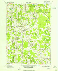 1954 Hannibal1955 Print · USGSThe Oswego and Cayuga County line comes alive in the mid-1950s, showing a landscape of rail-fed hamlets and agricultural crossroads. Researchers can trace family sites at Bethel Cem, follow the New York Central Railroad past Metcalf Siding, or explore small centers like Martville.2 unique versions available
 - 1954 Map of Cato, 1955 Print
 1954 Cato1955 Print · USGSMid-century Cayuga County is defined by its unique glacial topography and the growing rural hubs of Cato and Meridian. You can trace old family property lines along Brandt Road or find the White Cem and Cato-Meridian Central School.3 unique versions available
 - 1954 Map of Weedsport, 1961 Print
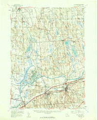 1954 Weedsport1961 Print · USGSMid-century Cayuga County is captured here as the new thruway begins to reshape the historic canal and rail corridor. Researchers can trace the legacy of the Erie Canal and New York Central through Port Byron, or locate family landmarks like Brick Ch and Schuler Farms Airfield.3 unique versions available
 - 1955 Map of Lysander, 1957 Print
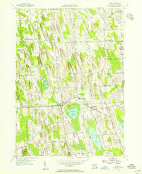
 1955 Lysander1957 Print · USGSMid-century Onondaga and Oswego Counties meet here along the historic Seneca River and Erie Canal corridor. Researchers can trace family homesteads near old crossroads like Little Utica, The Kingdom, and the rural Merritt Cem.3 unique versions available
 - 1955 Map of Fulton, 1957 Print
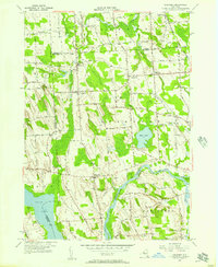
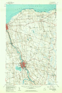
 1955 Fulton1957 Print · USGSMid-century Fulton and the surrounding Oswego County countryside are captured here during a period of steady industrial and civic expansion. Researchers can trace historic family locations near Bowens Corners, old rural schoolhouses, and the rail corridors of the New York Central.4 unique versions available
 - 1956 Map of Fulton, 1961 Print
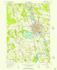
 1956 Fulton1961 Print · USGSOswego County's industrial river corridor and lakeside hamlets are captured here during the mid-fifties. Researchers can trace the dual lines of the Erie Lackawanna Railroad and the New York Central Railroad past Lake Neatahwanta and through Fulton.2 unique versions available
 - 1957 Map of Baldwinsville, 1961 Print
 1957 Baldwinsville1961 Print · USGSBaldwinsville and the river-rife lands of Onondaga County are shown here in the late fifties as the New York State Thruway began to reshape travel. Genealogists and local historians can locate many rural burial grounds, including Kingdom Cem and Elbridge Rural Cem, alongside the industrial lines of the Lackawanna Railroad.
End of results
Showing maps 1-7 of 7
Top cities near Ira
- Camillus historical maps
- Lysander historical maps
- Oswego historical maps
- Van Buren historical maps
- Fulton historical maps
- Schroeppel historical maps
See more
Top neighborhoods of Ira
Frequently asked questions
- What are the different types of historical maps available for Ira?
- What is the oldest map of Ira?
- Where can I purchase historical maps of Ira for my home or office?
- Where can I download high-res historical maps of Ira?
- Are there historical topographic maps available for Ira?
- Is there historical aerial imagery available for Ira?
- Where are historical maps of Ira sourced from?