Old Maps of Sennett, New York for Academic Research
Study the evolution of Sennett with 50 high-resolution historic maps. Whether you're teaching, researching, or modeling changes in land use, these maps provide essential visual documentation of urban, environmental, and geographic change.
- Analyze long-term change: Track patterns in development, transportation, and natural features.
- Ideal for environmental or urban studies: Support academic projects with primary historical map data.
- Use in the classroom or lab: Educators and researchers rely on these maps to bring historical context to life.
These maps are a powerful tool for teaching, research, and visualizing how Sennett has changed over the decades.
Sennett, NY maps
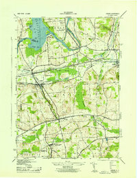
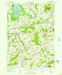
(50)- 1899 Map of Auburn
 1899 Auburn1899 Print · USGSThe Finger Lakes region thrived at the close of the nineteenth century as a hub of rail and water transport. Genealogists can trace family names at Coonley Corners or locate early industrial sites like Howard Mill and the State Dam.
 - 1899 Map of Skaneateles
 1899 Skaneateles1899 Print · USGSThe Finger Lakes at the end of the nineteenth century reveal a landscape of lakeside steamboat landings and bustling mill towns. Follow the Steamboat Route from Skaneateles to Glen Haven, or trace the rural roads connecting Marysville, Borodino, and Marcellus.
 - 1900 Map of Baldwinsville
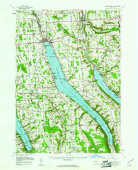
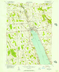
 1900 Baldwinsville1900 Print · USGSOnondaga and Oswego counties are seen here at the close of the nineteenth century, when the Erie Canal still drove local commerce. Genealogists can trace family roots through canal towns like Jordan and river hubs like Baldwinsville and Phoenix.9 unique versions available
 - 1902 Map of Skaneateles
 1902 Skaneateles1902 Print · USGSOnondaga and Cayuga counties come alive in the Victorian era as a network of steamboats and short-line railroads connects lakeside hamlets. Trace ancestral roots and old transport routes through Mottville, the Skaneateles RR, and remote landings like Gregory Ldg.9 unique versions available
 - 1902 Map of Weedsport
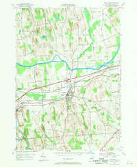
 1902 Weedsport1902 Print · USGSCentral New York at the turn of the century reveals a landscape shaped by the Erie Canal and a dense network of early railroads. Genealogists and historians can trace the foundations of Weedsport and Port Byron, or locate landmarks like the Brick Church and the Canal Basin at Montezuma.10 unique versions available
 - 1902 Map of Auburn
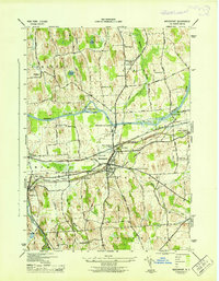
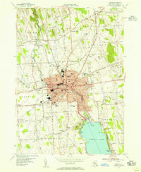
 1902 Auburn1902 Print · USGSThe Finger Lakes region thrived at the turn of the century as a hub of rail lines and canal traffic. Genealogists and historians can trace old homesteads and landings from Union Springs to Throopsville, including the complex rail junctions at Cayuga Junction and Aurelius Sta.9 unique versions available
 - 1943 Map of Jordan
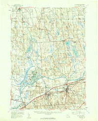
 1943 Jordan1943 Print · USGSJordan and Elbridge are centers of industry and transit during the mid-forties, where the old canal system meets the modern rail era. Trace the path of the ERIE CANAL, locate family roots at MAPLE GROVE CEM, or find old schoolhouses like School No 11 and School No 12.
 - 1943 Map of Weedsport
 1943 Weedsport1943 Print · USGSMid-century Cayuga County is defined by its deep layering of transport history as the modern Barge Canal replaces the original Erie route. Researchers can trace the transition between eras at the Weedsport Canal Terminal and the Erie Canal (Abandoned), or locate family sites like La Due Cem and Brick Church.
 - 1943 Map of Auburn
 1943 Auburn1943 Print · USGSMid-century Auburn and its lakefront were defined by a mix of heavy industry and institutional landmarks during the war years. Genealogists and researchers can trace local family history through numerous rural burial grounds like Soule Cem and schools such as Seward Sch.
 - 1943 Map of Skaneateles
 1943 Skaneateles1943 Print · USGSThe northern tip of Skaneateles Lake and its industrial outlet are captured here in the early 1940s during a period of steady lakeside growth. Genealogists and local historians can trace family locations through numerous rural landmarks like Lakeview Cem, School No 17, and the mills of Mottville.
 - 1949 Map of Skaneateles
 1949 Skaneateles1949 Print · USGSThe eastern shores of Skaneateles Lake appear in the late 1940s as a mix of summer colonies and thriving milling hamlets. Family historians can locate dozens of specific sites including St Marys Cem, Wicks Corners, and School No 5.
 - 1950 Map of Elmira
 1950 Elmira1950 Print · USGSThe Finger Lakes region thrived in the late 1940s as a hub of industry and transport. Trace family roots and vanished landmarks near Seneca Lake or explore the rail lines of the Erie RR and the sprawling Seneca Ordnance Depot.2 unique versions available
 - 1953 Map of Auburn
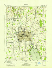
 1953 Auburn1953 Print · USGSAuburn and its surrounding townships thrive in the mid-twentieth century as a major center for industry, rail, and state institutions. Genealogists and local historians can trace the footprints of Auburn State Prison, the Childrens Home, and numerous local burial grounds like Fort Hill Cem and Soule Cem.
 - 1954 Map of Auburn, 1955 Print
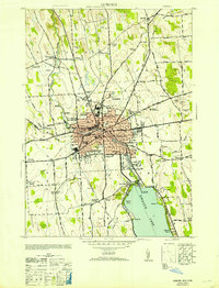
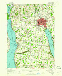
 1954 Auburn1955 Print · USGSThe industrial hub of Auburn and the northern reaches of Owasco Lake are captured here during the mid-fifties. Genealogists and researchers can trace family names at Fort Hill Cemetery, locate the old Half Acre Sta, or follow the Lehigh Valley Railroad through Aurelius.3 unique versions available
 - 1954 Map of Weedsport, 1956 Print
 1954 Weedsport1956 Print · USGSMid-century Cayuga County is defined by its transit corridors, where the New York State Thruway meets older rail lines and canal beds. You can trace family roots at Weedsport Rural Cem or locate former landmarks like the Arthur Gates Sch and the Weedsport Canal Terminal.4 unique versions available
 - 1954 Map of Weedsport, 1961 Print
 1954 Weedsport1961 Print · USGSMid-century Cayuga County is captured here as the new thruway begins to reshape the historic canal and rail corridor. Researchers can trace the legacy of the Erie Canal and New York Central through Port Byron, or locate family landmarks like Brick Ch and Schuler Farms Airfield.3 unique versions available
 - 1955 Map of Skaneateles, 1957 Print
 1955 Skaneateles1957 Print · USGSThe Finger Lakes region of Central New York is shown here in the mid-fifties, centered on the deep waters of Skaneateles Lake. Researchers can trace the industrial Skaneateles Short Line Railroad or locate local landmarks like Twelve Corners Sch and St Marys Cem.2 unique versions available
 - 1955 Map of Jordan, 1957 Print
 1955 Jordan1957 Print · USGSOnondaga County in the mid-fifties shows a landscape of canal-era villages and vital rail connections during the early years of the Thruway. Researchers can locate the Skaneateles Junction, trace the Erie Canal through Jordan, and find family sites near Maple Grove Cem.2 unique versions available
 - 1955 Map of Skaneateles, 1957 Print
 1955 Skaneateles1957 Print · USGSSkaneateles and its northern industrial corridor are shown in detail during the mid-fifties. You can trace the path of the Skaneateles Short Line RR and locate local landmarks like Baptist Corners, Shepard Settlement, and Lakeview Cem.3 unique versions available
 - 1956 Map of Auburn, 1961 Print
 1956 Auburn1961 Print · USGSMid-century Cayuga County is defined by the industrial engine of Auburn and the busy shorelines of Cayuga and Owasco Lakes. Genealogists and historians can trace family ties through Old Quaker Cem, locate the old Half Acre Sta, and see the early footprint of the New York State Thruway.2 unique versions available
 - 1957 Map of Baldwinsville, 1961 Print
 1957 Baldwinsville1961 Print · USGSBaldwinsville and the river-rife lands of Onondaga County are shown here in the late fifties as the New York State Thruway began to reshape travel. Genealogists and local historians can locate many rural burial grounds, including Kingdom Cem and Elbridge Rural Cem, alongside the industrial lines of the Lackawanna Railroad.
 - 1958 Map of Elmira
 1958 Elmira1958 Print · USGSThe New York Finger Lakes during the late fifties reveal a complex landscape of glacial geology and industrial growth. Researchers can trace historic transport corridors like the Erie Canal and Erie RR, or locate institutional landmarks like Cornell University.2 unique versions available
 - 1960 Map of Rochester
 1960 Rochester1960 Print · USGSThe Lake Ontario shoreline in the late fifties was a bustling corridor of rail and water commerce. Genealogists and historians can trace the path of the New York Central through canal towns like Newark or explore the coastal landmarks around Sackets Harbor.2 unique versions available
 - 1961 Map of Rochester, 1973 Print
 1961 Rochester1973 Print · USGSThe Lake Ontario shoreline and Finger Lakes frontier are shown here at the height of the mid-century infrastructure boom. Genealogists and historians can trace the rail-and-road evolution from Sackets Harbor down to the New York State Thruway, passing through centers like Pulaski and Adams Center.3 unique versions available
 - 1962 Map of Elmira, 1969 Print
 1962 Elmira1969 Print · USGSThe Finger Lakes region and Southern Tier are captured here during a period of industrial maturity and highway expansion. Researchers can trace the path of the Erie Canal, the footprint of the Seneca Army Depot, and legacy rail lines through Elmira and Ithaca.4 unique versions available
Showing maps 1-25 of 50
Top cities near Sennett
- Auburn historical maps
- Camillus historical maps
- Lysander historical maps
- Onondaga historical maps
- Van Buren historical maps
- Seneca Falls historical maps
See more
Frequently asked questions
- What are the different types of historical maps available for Sennett?
- What is the oldest map of Sennett?
- Where can I purchase historical maps of Sennett for my home or office?
- Where can I download high-res historical maps of Sennett?
- Are there historical topographic maps available for Sennett?
- Is there historical aerial imagery available for Sennett?
- Where are historical maps of Sennett sourced from?