1940s Maps of Sennett, New York
Explore 5 historic maps of Sennett from the 1940s. These maps offer a rare glimpse into what life looked like during the 1940s — showing old roads, neighborhoods, homes, and landmarks that have changed or disappeared over time.
Whether you're researching your family's past, planning a metal detecting trip, or studying how Sennett's landscape evolved across the 1940s, these high-resolution maps are a powerful tool for exploring the history of this region.
- Focus on a specific era: All maps on this page are from the 1940s, giving you a focused view of this time period.
- See what’s changed: Compare century-old streets, trails, and buildings to today's modern landscape using overlays and satellite layers.
- Research with precision: Use these maps for genealogy, historical research, land use analysis, or educational projects.
- View, download, or print: Maps are fully viewable online in high resolution, and can be downloaded or printed for your own records.
Start exploring Sennett's history through authentic maps from the 1940s. This is your window into the past.
Sennett, NY maps
(5)- 1943 Map of Jordan
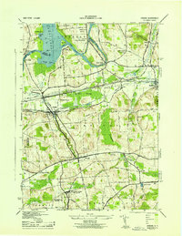 1943 Jordan1943 Print · USGSJordan and Elbridge are centers of industry and transit during the mid-forties, where the old canal system meets the modern rail era. Trace the path of the ERIE CANAL, locate family roots at MAPLE GROVE CEM, or find old schoolhouses like School No 11 and School No 12.
 - 1943 Map of Weedsport
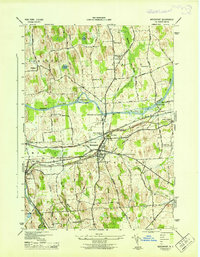 1943 Weedsport1943 Print · USGSMid-century Cayuga County is defined by its deep layering of transport history as the modern Barge Canal replaces the original Erie route. Researchers can trace the transition between eras at the Weedsport Canal Terminal and the Erie Canal (Abandoned), or locate family sites like La Due Cem and Brick Church.
 - 1943 Map of Auburn
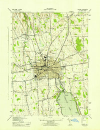 1943 Auburn1943 Print · USGSMid-century Auburn and its lakefront were defined by a mix of heavy industry and institutional landmarks during the war years. Genealogists and researchers can trace local family history through numerous rural burial grounds like Soule Cem and schools such as Seward Sch.
 - 1943 Map of Skaneateles
 1943 Skaneateles1943 Print · USGSThe northern tip of Skaneateles Lake and its industrial outlet are captured here in the early 1940s during a period of steady lakeside growth. Genealogists and local historians can trace family locations through numerous rural landmarks like Lakeview Cem, School No 17, and the mills of Mottville.
 - 1949 Map of Skaneateles
 1949 Skaneateles1949 Print · USGSThe eastern shores of Skaneateles Lake appear in the late 1940s as a mix of summer colonies and thriving milling hamlets. Family historians can locate dozens of specific sites including St Marys Cem, Wicks Corners, and School No 5.
End of results
Showing maps 1-5 of 5
Top cities near Sennett
- Auburn historical maps
- Camillus historical maps
- Lysander historical maps
- Onondaga historical maps
- Van Buren historical maps
- Seneca Falls historical maps
See more
Frequently asked questions
- What are the different types of historical maps available for Sennett?
- What is the oldest map of Sennett?
- Where can I purchase historical maps of Sennett for my home or office?
- Where can I download high-res historical maps of Sennett?
- Are there historical topographic maps available for Sennett?
- Is there historical aerial imagery available for Sennett?
- Where are historical maps of Sennett sourced from?