
1949 Map of Skaneateles
USGS Topo · Published 1949About this map
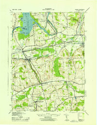
Skaneateles Lake dominates this 1940s landscape, with its eastern shore showing early lakeside developments such as Thornton Grove, Edgewater Park, and Thornton Heights. Further north, the town of Skaneateles serves as the focal point where the Skaneateles Creek begins its journey through industrial corridors like Mottville and Skaneateles Falls.
Find a feature on this map
62 named features on this map. Tap any name to fly to it.
Don’t see what you’re looking for? This feature index may not catch every label — zoom into the map to look around manually.
Map Details
Editions of this 1949 Skaneateles Map
This is the sole edition of this map. No revisions or reprints were ever made.
Other maps of this area

1899 · Auburn
USGS Topo · 1:62,500

1899 · Skaneateles
USGS Topo · 1:62,500

1900 · Baldwinsville
USGS Topo · 1:62,500

1902 · Skaneateles
USGS Topo · 1:62,500

1902 · Weedsport
USGS Topo · 1:62,500

1902 · Auburn
USGS Topo · 1:62,500
1943 · Jordan
USGS Topo · 1:31,680

1943 · Spafford
USGS Topo · 1:31,680
1943 · Owasco
USGS Topo · 1:31,680

1943 · Scipio
USGS Topo · 1:31,680