
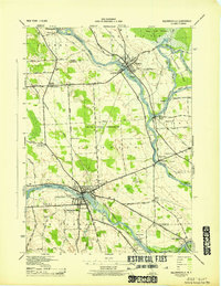
1943 Map of Jordan
USGS Topo · Published 1943About this map
Jordan and Elbridge serve as the primary hubs in this central New York landscape during the early 1940s, an era defined by a complex intersection of transportation systems. The Erie Canal, marked in segments as abandoned, runs parallel to the modern State Barge Canal and the New York Central RR, illustrating the industrial evolution of the Mohawk Valley corridor. To the north, the Seneca River winds through Jacks Reef, while the southern reaches are dominated by family-named landmarks like Science Hill and Ashbys Pinnacle. Genealogists will find significant detail in the rural landscape, including Maple Grove Cem and Mount Pleasant Cem, alongside several numbered schoolhouses like School No 5 and School No 11. The area near Skaneateles Junction Hart Lot (PO) and the Fish Hatchery south of Half Way provides a look at the local economy and community structure just before mid-century suburbanization began to alter these agricultural townships.
Find a feature on this map
85 named features on this map. Tap any name to fly to it.
Don’t see what you’re looking for? This feature index may not catch every label — zoom into the map to look around manually.
Map Details
Editions of this 1943 Jordan Map
This is the sole edition of this map. No revisions or reprints were ever made.
Other maps of this area

1899 · Auburn
USGS Topo · 1:62,500

1899 · Skaneateles
USGS Topo · 1:62,500

1900 · Baldwinsville
USGS Topo · 1:62,500

1902 · Skaneateles
USGS Topo · 1:62,500

1902 · Weedsport
USGS Topo · 1:62,500

1902 · Auburn
USGS Topo · 1:62,500

1943 · Lysander
USGS Topo · 1:31,680

1943 · Cato
USGS Topo · 1:31,680

1943 · Weedsport
USGS Topo · 1:31,680
1943 · Baldwinsville
USGS Topo · 1:31,680