1900-1909 Maps of Arkwright, New York
Explore 2 historic maps of Arkwright from 1900-1909. These maps offer a rare glimpse into what life looked like during the 1900s — showing old roads, neighborhoods, homes, and landmarks that have changed or disappeared over time.
Whether you're researching your family's past, planning a metal detecting trip, or studying how Arkwright's landscape evolved across the 1900s, these high-resolution maps are a powerful tool for exploring the history of this region.
- Focus on a specific era: All maps on this page are from the 1900s, giving you a focused view of this time period.
- See what’s changed: Compare century-old streets, trails, and buildings to today's modern landscape using overlays and satellite layers.
- Research with precision: Use these maps for genealogy, historical research, land use analysis, or educational projects.
- View, download, or print: Maps are fully viewable online in high resolution, and can be downloaded or printed for your own records.
Start exploring Arkwright's history through authentic maps from the 1900s. This is your window into the past.
Arkwright, NY maps
(2)- 1900 Map of Dunkirk
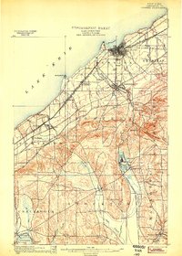 1900 Dunkirk1900 Print · USGSThe Lake Erie shoreline and Chautauqua hills are shown here in the late nineteenth century during a peak era of railroad expansion. Genealogists can trace early post offices like Van Buren (Cushing P.O.) and established towns such as Fredonia and Brocton.6 unique versions available
 - 1900 Map of Cherry Creek
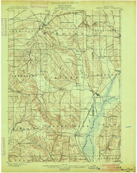 1900 Cherry Creek1900 Print · USGSWestern New York near the turn of the century shows a landscape of developing rail hubs and managed wetlands. Genealogists can trace family roots through settlements like Forestville, South Dayton, and Leon, or locate vanished stations like Smiths Mills Sta. and the rural crossroads at Charlotte Center.6 unique versions available
End of results
Showing maps 1-2 of 2
Top cities near Arkwright
- Evans historical maps
- Pomfret historical maps
- Dunkirk historical maps
- Fredonia historical maps
- Ellicott historical maps
- Hanover historical maps
See more
Top neighborhoods of Arkwright
Frequently asked questions
- What are the different types of historical maps available for Arkwright?
- What is the oldest map of Arkwright?
- Where can I purchase historical maps of Arkwright for my home or office?
- Where can I download high-res historical maps of Arkwright?
- Are there historical topographic maps available for Arkwright?
- Is there historical aerial imagery available for Arkwright?
- Where are historical maps of Arkwright sourced from?