1950s Maps of Busti, New York
Explore 7 historic maps of Busti from the 1950s. These maps offer a rare glimpse into what life looked like during the 1950s — showing old roads, neighborhoods, homes, and landmarks that have changed or disappeared over time.
Whether you're researching your family's past, planning a metal detecting trip, or studying how Busti's landscape evolved across the 1950s, these high-resolution maps are a powerful tool for exploring the history of this region.
- Focus on a specific era: All maps on this page are from the 1950s, giving you a focused view of this time period.
- See what’s changed: Compare century-old streets, trails, and buildings to today's modern landscape using overlays and satellite layers.
- Research with precision: Use these maps for genealogy, historical research, land use analysis, or educational projects.
- View, download, or print: Maps are fully viewable online in high resolution, and can be downloaded or printed for your own records.
Start exploring Busti's history through authentic maps from the 1950s. This is your window into the past.
Busti, NY maps
(7)- 1954 Map of Russell, 1956 Print
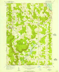
 1954 Russell1956 Print · USGSWarren County in the mid-1950s shows a landscape of institutional farms and rural crossroads along the Conewango Creek. Trace the New York Central Railroad corridor through Russell and Akeley, or locate ancestral sites like Marshtown Cem and Putnamville.4 unique versions available
 - 1954 Map of Jamestown, 1956 Print
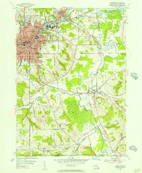 1954 Jamestown1956 Print · USGSJamestown and its neighboring valleys in the mid-fifties show a bustling industrial center transitioning into Chautauqua County farmland. Researchers can trace family roots through numerous sites like Mt Olivet Cem, Lillian Dickson Sch, and the outlying hamlet of Frewsburg.3 unique versions available
 - 1954 Map of Panama, 1957 Print
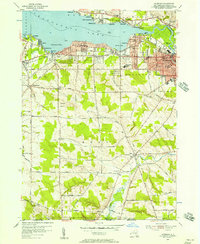
 1954 Panama1957 Print · USGSChautauqua County in the mid-fifties shows a landscape of reforestation and lakeside living along Chautauqua Lake. Researchers can trace the Erie Railroad through Watts Flats and Niobe, or locate family sites like Greenwood Cem and Union Cem.2 unique versions available
 - 1954 Map of Lakewood, 1957 Print
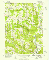
 1954 Lakewood1957 Print · USGSMid-century Chautauqua Lake life is captured here during a time of lakeside growth and rural continuity. Genealogists and local researchers can trace the Erie Railroad route through Celoron or locate family sites like Bentley Cem and the village of Busti.3 unique versions available
 - 1957 Map of Warren, 1964 Print
 1957 Warren1964 Print · USGSThe northern Pennsylvania oil and timber country comes into focus in the mid-fifties, showing the region before modern highway expansions. Trace the industrial rail networks of the Pennsylvania RR and the early Allegheny River Reservoir near Warren and Oil City.4 unique versions available
 - 1958 Map of Warren
 1958 Warren1958 Print · USGSNorthern Pennsylvania’s timber and oil country is captured here during the late fifties, showing the interplay of industrial valleys and vast state forests. Genealogists can trace family connections across the Cornplanter Indian Reservation or through rail hubs like Oil City and Saint Marys.
 - 1959 Map of Warren
 1959 Warren1959 Print · USGSNorthern Pennsylvania's oil and timber country comes alive in this late-fifties study of the forest-clad plateaus. Trace the historic Cornplanter (Indian Reservation), the sprawling Oil Field, and the rail lines of the Pennsylvania RR.2 unique versions available
End of results
Showing maps 1-7 of 7
Top cities near Busti
- Jamestown historical maps
- Warren historical maps
- Ellicott historical maps
- Westfield historical maps
- Ellery historical maps
- Chautauqua historical maps
See more
Top neighborhoods of Busti
- Loomises historical maps
- Cottage Park historical maps
- Shermans Bay historical maps
- Boomertown historical maps
- Vukote historical maps
- Maple Point historical maps
See more
Frequently asked questions
- What are the different types of historical maps available for Busti?
- What is the oldest map of Busti?
- Where can I purchase historical maps of Busti for my home or office?
- Where can I download high-res historical maps of Busti?
- Are there historical topographic maps available for Busti?
- Is there historical aerial imagery available for Busti?
- Where are historical maps of Busti sourced from?