1900s (20th Century) Maps of Busti, New York
Explore 27 historic maps of Busti from the 1900s (20th Century). These maps offer a rare glimpse into what life looked like during the 1900s — showing old roads, neighborhoods, homes, and landmarks that have changed or disappeared over time.
Whether you're researching your family's past, planning a metal detecting trip, or studying how Busti's landscape evolved across the 1900s, these high-resolution maps are a powerful tool for exploring the history of this region.
- Focus on a specific era: All maps on this page are from the 1900s, giving you a focused view of this time period.
- See what’s changed: Compare century-old streets, trails, and buildings to today's modern landscape using overlays and satellite layers.
- Research with precision: Use these maps for genealogy, historical research, land use analysis, or educational projects.
- View, download, or print: Maps are fully viewable online in high resolution, and can be downloaded or printed for your own records.
Start exploring Busti's history through authentic maps from the 1900s. This is your window into the past.
Busti, NY maps
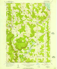
(27)- 1904 Map of Chautaqua
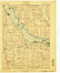 1904 Chautaqua1904 Print · USGSWestern New York at the turn of the century reveals a landscape defined by waterfront resorts and bustling rail corridors. Trace the historic Steamboat Route on Chautauqua Lake or locate old settlements like Bemus Point and Dewittville.6 unique versions available
 - 1905 Map of Jamestown
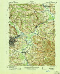
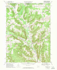
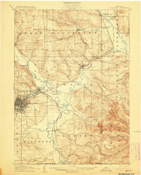 1905 Jamestown1905 Print · USGSJamestown and the surrounding Chautauqua County valleys are captured here at the start of the twentieth century. Researchers can trace early rail corridors like the Erie R.R. and locate family-named landmarks in Frewsburg, Ellington, and Kiantone.5 unique versions available
 - 1906 Map of Warren
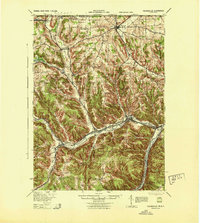
 1906 Warren1906 Print · USGSWarren and its surrounding river valleys are captured here at the height of the early rail era. Genealogists can trace family names across dozens of rural landmarks, from the State Insane Asylum to scattered outposts like Lander and Old Clarendon.3 unique versions available
 - 1907 Map of Warren
 1907 Warren1907 Print · USGSWarren and its riverfront neighborhoods thrived at the dawn of the century as a hub for the Pennsylvania RR. Local historians can trace the footprint of the State Insane Asylum and find rural schools such as Dutch Hill School and Knupp School.
 - 1908 Map of Warren
 1908 Warren1908 Print · USGSThe river-and-rail economy of Warren County is documented here at the turn of the century. Genealogists can trace family-named landmarks and rural hubs like Lander, Oakland Cem, and the State Insane Asylum.3 unique versions available
 - 1926 Map of Youngsville, 1961 Print
 1926 Youngsville1961 Print · USGSWarren County at the dawn of the motorized age shows a landscape of small valley towns and isolated hill farms. Local researchers can trace old schoolhouse locations like White Sch and family-named landmarks such as Pikes Rocks and Cole Hill Fire Tower.
 - 1929 Map of Youngsville
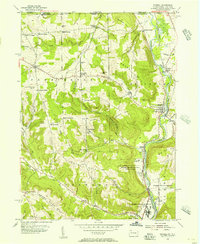
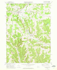
 1929 Youngsville1929 Print · USGSWarren County at the close of the twenties shows a landscape of busy rail junctions and upland farm communities. You can trace early family sites through dozens of named schoolhouses like Yankebush Sch, find the Cole Hill Fire Tower, or follow the Erie RR through Bear Lake.5 unique versions available
 - 1941 Map of Chautauqua
 1941 Chautauqua1941 Print · USGSChautauqua Lake was a bustling hub of rail and water travel in the early 1940s. Genealogists and local historians can trace family-named sites like Starr Farm and Jones Corners alongside the path of the Chautauqua Traction Co.
 - 1942 Map of Jamestown
 1942 Jamestown1942 Print · USGSJamestown and the Chautauqua County interior are captured here in the early 1940s, showing a landscape defined by industry and deep-set river valleys. Genealogists can trace family roots in old settlements like Frewsburg, Gerry, and the Rutledge Conewango PO.
 - 1943 Map of Youngsville
 1943 Youngsville1943 Print · USGSThe valleys and ridges of Warren County appear in detail during the early 1940s, highlighting the rail-to-river economy along the Allegheny River. Genealogists can trace family roots through numerous hill schools and rural churches like Davy Hill Ch and Vankirkbush Sch.
 - 1954 Map of Russell, 1956 Print
 1954 Russell1956 Print · USGSWarren County in the mid-1950s shows a landscape of institutional farms and rural crossroads along the Conewango Creek. Trace the New York Central Railroad corridor through Russell and Akeley, or locate ancestral sites like Marshtown Cem and Putnamville.4 unique versions available
 - 1954 Map of Jamestown, 1956 Print
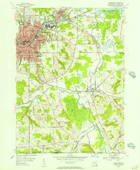 1954 Jamestown1956 Print · USGSJamestown and its neighboring valleys in the mid-fifties show a bustling industrial center transitioning into Chautauqua County farmland. Researchers can trace family roots through numerous sites like Mt Olivet Cem, Lillian Dickson Sch, and the outlying hamlet of Frewsburg.3 unique versions available
 - 1954 Map of Panama, 1957 Print
 1954 Panama1957 Print · USGSChautauqua County in the mid-fifties shows a landscape of reforestation and lakeside living along Chautauqua Lake. Researchers can trace the Erie Railroad through Watts Flats and Niobe, or locate family sites like Greenwood Cem and Union Cem.2 unique versions available
 - 1954 Map of Lakewood, 1957 Print
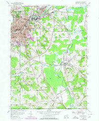
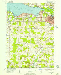 1954 Lakewood1957 Print · USGSMid-century Chautauqua Lake life is captured here during a time of lakeside growth and rural continuity. Genealogists and local researchers can trace the Erie Railroad route through Celoron or locate family sites like Bentley Cem and the village of Busti.3 unique versions available
 - 1957 Map of Warren, 1964 Print
 1957 Warren1964 Print · USGSThe northern Pennsylvania oil and timber country comes into focus in the mid-fifties, showing the region before modern highway expansions. Trace the industrial rail networks of the Pennsylvania RR and the early Allegheny River Reservoir near Warren and Oil City.4 unique versions available
 - 1958 Map of Warren
 1958 Warren1958 Print · USGSNorthern Pennsylvania’s timber and oil country is captured here during the late fifties, showing the interplay of industrial valleys and vast state forests. Genealogists can trace family connections across the Cornplanter Indian Reservation or through rail hubs like Oil City and Saint Marys.
 - 1959 Map of Warren
 1959 Warren1959 Print · USGSNorthern Pennsylvania's oil and timber country comes alive in this late-fifties study of the forest-clad plateaus. Trace the historic Cornplanter (Indian Reservation), the sprawling Oil Field, and the rail lines of the Pennsylvania RR.2 unique versions available
 - 1960 Map of Buffalo
 1960 Buffalo1960 Print · USGSWestern New York and the Niagara Peninsula thrive during the mid-twentieth century industrial peak. Genealogists and historians can trace family-named points and early settlements from Dunkirk Light to the Allegany Indian Reservation.
 - 1962 Map of Buffalo, 1980 Print
 1962 Buffalo1980 Print · USGSThe Niagara Frontier and Western New York are captured here in the early sixties, showing the vital industrial and maritime nexus between the U.S. and Canada. Researchers can trace the path of the Welland Canal, locate the Allegany Indian Reservation, or find family sites near Chautauqua Lake.2 unique versions available
 - 1967 Map of Buffalo
 1967 Buffalo1967 Print · USGSWestern New York and the Lake Erie shoreline are shown here during the mid-1960s industrial peak. Researchers can trace the massive rail networks of the Erie Railroad, locate the Cattaraugus Indian Reservation, or find historic sites like Fort Erie.
 - 1968 Map of Lottsville, 1971 Print
 1968 Lottsville1971 Print · USGSWarren County’s northern borderlands in the late sixties remain a landscape of creek-side villages and family-named landmarks. Genealogists and local historians can trace burial sites at Bear Lake Cem or Brooks Hill Cem and follow the old Erie-Lackawanna rail line.3 unique versions available
 - 1968 Map of Sugar Grove, 1972 Print
 1968 Sugar Grove1972 Print · USGSThe Pennsylvania and New York border comes alive in the late sixties, showing a landscape of small farming valleys and early energy development. Genealogists and local historians can trace family roots through landmarks like Peoples Ch, Wesleyan Cem, and the old Stillwater Road.3 unique versions available
 - 1971 Map of Warren
 1971 Warren1971 Print · USGSNorth Central Pennsylvania is captured here in the early seventies, showing a landscape defined by industrial centers and massive state forests. Genealogists and historians can trace the rail lines of the Penn Central and Erie Lackawanna connecting towns like Warren, Kane, and Du Bois.
 - 1973 Map of Buffalo
 1973 Buffalo1973 Print · USGSWestern New York and Ontario's Golden Horseshoe meet in the early seventies, spanning from the industrial waterfronts of Buffalo to the hills of Allegany State Park. Trace the paths of the Welland Canal and Erie Lackawanna railroad through the lakefront towns of Dunkirk and Port Colborne.
 - 1979 Map of Jamestown, 1980 Print
 1979 Jamestown1980 Print · USGSJamestown and its surrounding Chautauqua County townships are shown here during the late 1970s, illustrating the transition from urban industry to river valley farmland. Genealogists can trace family names and local history across Falconer, Frewsburg, and Kiantone, while locating sites like Mt Olivet Cem and Riverside Sch.
Showing maps 1-25 of 27
Top cities near Busti
- Jamestown historical maps
- Warren historical maps
- Ellicott historical maps
- Westfield historical maps
- Ellery historical maps
- Chautauqua historical maps
See more
Top neighborhoods of Busti
- Loomises historical maps
- Cottage Park historical maps
- Shermans Bay historical maps
- Boomertown historical maps
- Vukote historical maps
- Maple Point historical maps
See more
Frequently asked questions
- What are the different types of historical maps available for Busti?
- What is the oldest map of Busti?
- Where can I purchase historical maps of Busti for my home or office?
- Where can I download high-res historical maps of Busti?
- Are there historical topographic maps available for Busti?
- Is there historical aerial imagery available for Busti?
- Where are historical maps of Busti sourced from?