1950s Maps of North Harmony, New York
Explore 6 historic maps of North Harmony from the 1950s. These maps offer a rare glimpse into what life looked like during the 1950s — showing old roads, neighborhoods, homes, and landmarks that have changed or disappeared over time.
Whether you're researching your family's past, planning a metal detecting trip, or studying how North Harmony's landscape evolved across the 1950s, these high-resolution maps are a powerful tool for exploring the history of this region.
- Focus on a specific era: All maps on this page are from the 1950s, giving you a focused view of this time period.
- See what’s changed: Compare century-old streets, trails, and buildings to today's modern landscape using overlays and satellite layers.
- Research with precision: Use these maps for genealogy, historical research, land use analysis, or educational projects.
- View, download, or print: Maps are fully viewable online in high resolution, and can be downloaded or printed for your own records.
Start exploring North Harmony's history through authentic maps from the 1950s. This is your window into the past.
North Harmony, NY maps
(6)- 1954 Map of Chautauqua, 1956 Print
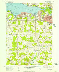
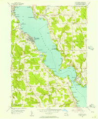 1954 Chautauqua1956 Print · USGSThe mid-century resort and educational character of the lake is captured here just as post-war recreation reached its peak. Genealogists and historians can trace family locations through Wild Rose Cem or explore landmarks like the Amphitheater and the Pennsylvania RR.3 unique versions available
 - 1954 Map of Ellery Center, 1956 Print
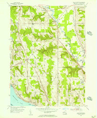 1954 Ellery Center1956 Print · USGSChautauqua County in the mid-fifties is captured here as a mix of lakeside landings and upland farming hamlets. Genealogists and local historians can trace family-named roads and landmarks like Kimball Stand, Phillips Mills, and the Jamestown Speedway.5 unique versions available
 - 1954 Map of Panama, 1957 Print
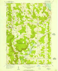 1954 Panama1957 Print · USGSChautauqua County in the mid-fifties shows a landscape of reforestation and lakeside living along Chautauqua Lake. Researchers can trace the Erie Railroad through Watts Flats and Niobe, or locate family sites like Greenwood Cem and Union Cem.2 unique versions available
 - 1954 Map of North Clymer, 1957 Print
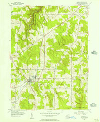
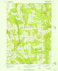 1954 North Clymer1957 Print · USGSThe dairy lands of Chautauqua County appear here in the mid-1950s, as rural settlements and railroads still define the local economy. Researchers can trace family homesteads along Petit Road, locate the old Panama Sta along the Pennsylvania Railroad, or find the Clymer Hill Ch.3 unique versions available
 - 1954 Map of Sherman, 1957 Print
 1954 Sherman1957 Print · USGSSouthwestern Chautauqua County in the mid-fifties is defined by the rail corridor and dairy lands surrounding Sherman. Genealogists and historians can trace family road names and locate rural landmarks like Slab City, Porter Cem, and the RR Sta.3 unique versions available
 - 1954 Map of Lakewood, 1957 Print
 1954 Lakewood1957 Print · USGSMid-century Chautauqua Lake life is captured here during a time of lakeside growth and rural continuity. Genealogists and local researchers can trace the Erie Railroad route through Celoron or locate family sites like Bentley Cem and the village of Busti.3 unique versions available
End of results
Showing maps 1-6 of 6
Top cities near North Harmony
- Jamestown historical maps
- Pomfret historical maps
- Ellicott historical maps
- Busti historical maps
- Corry historical maps
- Westfield historical maps
See more
Top neighborhoods of North Harmony
- Long View historical maps
- Stedman historical maps
- Stow historical maps
- Victoria historical maps
- Woodlawn historical maps
- Ashville historical maps
See more
Frequently asked questions
- What are the different types of historical maps available for North Harmony?
- What is the oldest map of North Harmony?
- Where can I purchase historical maps of North Harmony for my home or office?
- Where can I download high-res historical maps of North Harmony?
- Are there historical topographic maps available for North Harmony?
- Is there historical aerial imagery available for North Harmony?
- Where are historical maps of North Harmony sourced from?