1900-1909 Maps of North Harmony, New York
Explore 2 historic maps of North Harmony from 1900-1909. These maps offer a rare glimpse into what life looked like during the 1900s — showing old roads, neighborhoods, homes, and landmarks that have changed or disappeared over time.
Whether you're researching your family's past, planning a metal detecting trip, or studying how North Harmony's landscape evolved across the 1900s, these high-resolution maps are a powerful tool for exploring the history of this region.
- Focus on a specific era: All maps on this page are from the 1900s, giving you a focused view of this time period.
- See what’s changed: Compare century-old streets, trails, and buildings to today's modern landscape using overlays and satellite layers.
- Research with precision: Use these maps for genealogy, historical research, land use analysis, or educational projects.
- View, download, or print: Maps are fully viewable online in high resolution, and can be downloaded or printed for your own records.
Start exploring North Harmony's history through authentic maps from the 1900s. This is your window into the past.
North Harmony, NY maps
(2)- 1904 Map of Chautaqua
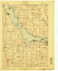 1904 Chautaqua1904 Print · USGSWestern New York at the turn of the century reveals a landscape defined by waterfront resorts and bustling rail corridors. Trace the historic Steamboat Route on Chautauqua Lake or locate old settlements like Bemus Point and Dewittville.6 unique versions available
 - 1905 Map of Clymer
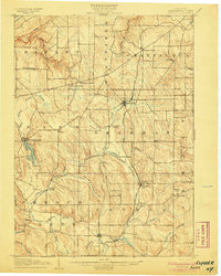 1905 Clymer1905 Print · USGSWestern Chautauqua County at the turn of the century shows a landscape of busy rail corridors and small rural hamlets. Genealogists can trace family roots through crossroads like Sheldon Corners or follow the old tracks through Sherman and Panama Sta.4 unique versions available
End of results
Showing maps 1-2 of 2
Top cities near North Harmony
- Jamestown historical maps
- Pomfret historical maps
- Ellicott historical maps
- Busti historical maps
- Corry historical maps
- Westfield historical maps
See more
Top neighborhoods of North Harmony
- Long View historical maps
- Stedman historical maps
- Stow historical maps
- Victoria historical maps
- Woodlawn historical maps
- Ashville historical maps
See more
Frequently asked questions
- What are the different types of historical maps available for North Harmony?
- What is the oldest map of North Harmony?
- Where can I purchase historical maps of North Harmony for my home or office?
- Where can I download high-res historical maps of North Harmony?
- Are there historical topographic maps available for North Harmony?
- Is there historical aerial imagery available for North Harmony?
- Where are historical maps of North Harmony sourced from?