1940s Maps of Sheridan, New York
Explore 4 historic maps of Sheridan from the 1940s. These maps offer a rare glimpse into what life looked like during the 1940s — showing old roads, neighborhoods, homes, and landmarks that have changed or disappeared over time.
Whether you're researching your family's past, planning a metal detecting trip, or studying how Sheridan's landscape evolved across the 1940s, these high-resolution maps are a powerful tool for exploring the history of this region.
- Focus on a specific era: All maps on this page are from the 1940s, giving you a focused view of this time period.
- See what’s changed: Compare century-old streets, trails, and buildings to today's modern landscape using overlays and satellite layers.
- Research with precision: Use these maps for genealogy, historical research, land use analysis, or educational projects.
- View, download, or print: Maps are fully viewable online in high resolution, and can be downloaded or printed for your own records.
Start exploring Sheridan's history through authentic maps from the 1940s. This is your window into the past.
Sheridan, NY maps
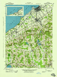
(4)- 1941 Map of Cherry Creek
 1941 Cherry Creek1941 Print · USGSChautauqua and Cattaraugus counties are captured here at the dawn of the 1940s, when the Erie railroad still bound these rural townships together. Genealogists can trace family footprints through numerous small villages like Forestville, South Dayton, and Charlotte Center.
 - 1943 Map of Dunkirk
 1943 Dunkirk1943 Print · USGSCoastal industry and rural spiritualist retreats meet in Chautauqua County during the early 1940s. Genealogists and historians can trace the rail corridors of the Nickel Plate and find local landmarks like Lily Dale, Cushing (PO), and the County Hospital.3 unique versions available
 - 1943 Map of Silver Creek, 1953 Print
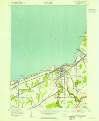 1943 Silver Creek1953 Print · USGSThe Lake Erie shoreline in Chautauqua County comes alive in this mid-century survey, showcasing a bustling rail corridor and beachside communities. Genealogists can trace family roots near Silver Creek, Hanover Center, or the Cattaraugus Indian Reservation.
 - 1944 Map of Silver Creek
 1944 Silver Creek1944 Print · USGSThe Lake Erie shoreline in the mid-1940s was a landscape defined by seasonal beach colonies and heavy rail traffic. Genealogists and historians can trace old homesteads along Old Forestville Road or explore the early layout of the Cattaraugus Indian Reservation and Silver Creek Airport.
End of results
Showing maps 1-4 of 4
Top cities near Sheridan
- Evans historical maps
- Pomfret historical maps
- Dunkirk historical maps
- Fredonia historical maps
- Hanover historical maps
- Collins historical maps
See more
Top neighborhoods of Sheridan
Frequently asked questions
- What are the different types of historical maps available for Sheridan?
- What is the oldest map of Sheridan?
- Where can I purchase historical maps of Sheridan for my home or office?
- Where can I download high-res historical maps of Sheridan?
- Are there historical topographic maps available for Sheridan?
- Is there historical aerial imagery available for Sheridan?
- Where are historical maps of Sheridan sourced from?