1970s Maps of Canaan, New York
Explore 4 historic maps of Canaan from the 1970s. These maps offer a rare glimpse into what life looked like during the 1970s — showing old roads, neighborhoods, homes, and landmarks that have changed or disappeared over time.
Whether you're researching your family's past, planning a metal detecting trip, or studying how Canaan's landscape evolved across the 1970s, these high-resolution maps are a powerful tool for exploring the history of this region.
- Focus on a specific era: All maps on this page are from the 1970s, giving you a focused view of this time period.
- See what’s changed: Compare century-old streets, trails, and buildings to today's modern landscape using overlays and satellite layers.
- Research with precision: Use these maps for genealogy, historical research, land use analysis, or educational projects.
- View, download, or print: Maps are fully viewable online in high resolution, and can be downloaded or printed for your own records.
Start exploring Canaan's history through authentic maps from the 1970s. This is your window into the past.
Canaan, NY maps
(4)- 1973 Map of State Line, 1974 Print
 1973 State Line1974 Print · USGSThe New York-Massachusetts state line in the early 1970s shows a high-country landscape shaped by early mining and modern transit. Researchers can trace the path of the Penn Central railroad or locate old burial grounds like St Patricks Cem and the West Stockbridge Cem.3 unique versions available
 - 1973 Map of Canaan, 1975 Print
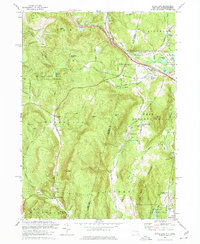
 1973 Canaan1975 Print · USGSThe Taconic Range borderlands in the early seventies feature a mix of racing culture and historic valley settlements. Trace the grounds of the Lebanon Valley Speedway or locate family sites at the Cemetery of the Evergreens and Canaan Center.4 unique versions available
 - 1975 Map of State Line, 1981 Print
 1975 State Line1981 Print · USGSThe border country between Massachusetts and New York is documented here in the mid-seventies, showing the rugged terrain of the Berkshires. Researchers can trace land patterns around West Stockbridge Center, Williamsville, and along the winding Green River.
 - 1975 Map of Canaan, 1981 Print
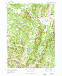
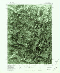 1975 Canaan1981 Print · USGSEastern Columbia County comes into focus in the mid-1970s through this detailed aerial orthophotomap. Researchers can trace the development of Canaan and New Lebanon, or locate rural homesteads near Queechy Lake and Flatbrook.
End of results
Showing maps 1-4 of 4
Top cities near Canaan
- Pittsfield historical maps
- East Greenbush historical maps
- Schodack historical maps
- Sand Lake historical maps
- Kinderhook historical maps
- Great Barrington historical maps
See more
Top neighborhoods of Canaan
- Red Rock historical maps
- Queechy historical maps
- Flatbrook historical maps
- Canaan Center historical maps
Frequently asked questions
- What are the different types of historical maps available for Canaan?
- What is the oldest map of Canaan?
- Where can I purchase historical maps of Canaan for my home or office?
- Where can I download high-res historical maps of Canaan?
- Are there historical topographic maps available for Canaan?
- Is there historical aerial imagery available for Canaan?
- Where are historical maps of Canaan sourced from?