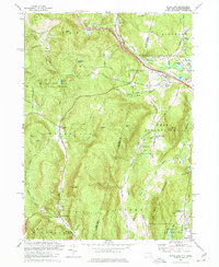
1973 Map of State Line
USGS Topo · Published 1974About this map
The borderlands of New York and Massachusetts are defined here by the steep elevations of Beebe Hill State Forest and Tom Ball Mountain. This 1973 survey details a landscape where industrial heritage and modern transit meet, centered on the Penn Central railroad and the Berkshire Section of the Thruway. Remnants of early iron mining are visible in the eastern half of the map, marked by Hudson Ore Bed Pond and Leet Ore Bed Pond, while small settlements like Richmond Furnace and Austerlitz maintain their historic footprints. Genealogists will find several local burial sites recorded, including St Patricks Cem and Austerlitz Cem. The mapping reflects a rural interior transitioning toward recreation, evidenced by Crane Lake Camp and Camp Kingsmont situated among the high ridges.
Find a feature on this map
58 named features on this map. Tap any name to fly to it.
Don’t see what you’re looking for? This feature index may not catch every label — zoom into the map to look around manually.
Map Details
Editions of this 1973 State Line Map
3 editions found
Other maps of this area

1885 · Sheffield
USGS Topo · 1:62,500

1888 · Sheffield
USGS Topo · 1:62,500

1888 · Pittsfield
USGS Topo · 1:62,500

1890 · Pittsfield
USGS Topo · 1:62,500

1891 · Sheffield
USGS Topo · 1:62,500

1893 · Sheffield
USGS Topo · 1:62,500

1893 · Pittsfield
USGS Topo · 1:62,500

1894 · Pittsfield
USGS Topo · 1:62,500

1897 · Pittsfield
USGS Topo · 1:62,500

1897 · Sheffield
USGS Topo · 1:62,500