1970s Maps of Cortland County, New York
Explore 4 historic maps of Cortland County from the 1970s. These maps offer a rare glimpse into what life looked like during the 1970s — showing old roads, neighborhoods, homes, and landmarks that have changed or disappeared over time.
Whether you're researching your family's past, planning a metal detecting trip, or studying how Cortland County's landscape evolved across the 1970s, these high-resolution maps are a powerful tool for exploring the history of this region.
- Focus on a specific era: All maps on this page are from the 1970s, giving you a focused view of this time period.
- See what’s changed: Compare century-old streets, trails, and buildings to today's modern landscape using overlays and satellite layers.
- Research with precision: Use these maps for genealogy, historical research, land use analysis, or educational projects.
- View, download, or print: Maps are fully viewable online in high resolution, and can be downloaded or printed for your own records.
Start exploring Cortland County's history through authentic maps from the 1970s. This is your window into the past.
Cortland County, NY maps
(4)- 1970 Map of Groton, 1974 Print
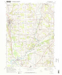 1970 Groton1974 Print · USGSThe rural crossroads of Tompkins and Cortland counties are captured in the early 1970s, showing the enduring agricultural character of the region. Researchers can trace the Lehigh Valley rail line or locate family-named settlements like Morton Corners and Lacy Corners.2 unique versions available
 - 1971 Map of Sempronius, 1974 Print
 1971 Sempronius1974 Print · USGSThe hills along the Cayuga and Cortland county line in the early seventies remain a landscape of deep gulfs and upland forests. Genealogists and hikers can trace the original locations of Morse Mill, Summer Hill Ch, and the Lickville Cem.
 - 1976 Map of Harford, 1984 Print
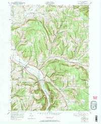 1976 Harford1984 Print · USGSCortland and Tioga Counties are shown here during the mid-to-late twentieth century, preserving a landscape of steep hollows and valley settlements. Genealogists can locate family landmarks like the Birthplace of John D Rockefeller and the old Harford Mills station.2 unique versions available
 - 1978 Map of Homer, 1979 Print
 1978 Homer1979 Print · USGSCortland County in the late seventies reveals a landscape of valley settlements and upland reforestation areas. Researchers can trace family history at Atwater Cem or explore the rural character of Slab City and Little York.
End of results
Showing maps 1-4 of 4
Top cities of Cortland County
- Cortland historical maps
- Cortlandville historical maps
- Homer historical maps
- Virgil historical maps
- Marathon historical maps
- Preble historical maps
See more
Frequently asked questions
- What are the different types of historical maps available for Cortland County?
- What is the oldest map of Cortland County?
- Where can I purchase historical maps of Cortland County for my home or office?
- Where can I download high-res historical maps of Cortland County?
- Are there historical topographic maps available for Cortland County?
- Is there historical aerial imagery available for Cortland County?
- Where are historical maps of Cortland County sourced from?