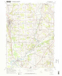
1970 Map of Groton
USGS Topo · Published 1974About this map
The Lehigh Valley railroad tracks trace a curving path through the village of Freeville and northward past the George Junior Republic High Sch, anchoring a landscape of small crossroads settlements and dairy country. This 1970 revision shows a rural network of family-named corners such as Morton Corners, Riggs Corners, and Merchants Corners, reflecting the persistent agricultural footprint of central New York. The terrain is marked by the convergence of several waterways, including Fall Creek and Virgil Creek, which once powered local industry at sites like Red Mills. In the northeast corner, the Cortland National Fish Hatchery stands as a notable federal facility, while the numerous small cemeteries, such as St Patricks Cem and East Groton Cem, provide essential data points for local genealogists tracing the area’s pioneer families and early residents.
Find a feature on this map
60 named features on this map. Tap any name to fly to it.
Don’t see what you’re looking for? This feature index may not catch every label — zoom into the map to look around manually.
Map Details
Editions of this 1970 Groton Map
2 editions found
Other maps of this area

1898 · Moravia
USGS Topo · 1:62,500

1900 · Dryden
USGS Topo · 1:62,500

1902 · Moravia
USGS Topo · 1:62,500

1903 · Cortland
USGS Topo · 1:62,500

1903 · Harford
USGS Topo · 1:62,500

1906 · Catatonk
USGS Topo · 1:125,000

1942 · Groton
USGS Topo · 1:24,000

1943 · Moravia
USGS Topo · 1:31,680

1943 · West Groton
USGS Topo · 1:31,680

1943 · Groton
USGS Topo · 1:31,680