1930s Maps of Milan, New York
Explore 4 historic maps of Milan from the 1930s. These maps offer a rare glimpse into what life looked like during the 1930s — showing old roads, neighborhoods, homes, and landmarks that have changed or disappeared over time.
Whether you're researching your family's past, planning a metal detecting trip, or studying how Milan's landscape evolved across the 1930s, these high-resolution maps are a powerful tool for exploring the history of this region.
- Focus on a specific era: All maps on this page are from the 1930s, giving you a focused view of this time period.
- See what’s changed: Compare century-old streets, trails, and buildings to today's modern landscape using overlays and satellite layers.
- Research with precision: Use these maps for genealogy, historical research, land use analysis, or educational projects.
- View, download, or print: Maps are fully viewable online in high resolution, and can be downloaded or printed for your own records.
Start exploring Milan's history through authentic maps from the 1930s. This is your window into the past.
Milan, NY maps
(4)- 1934 Map of Rhinebeck
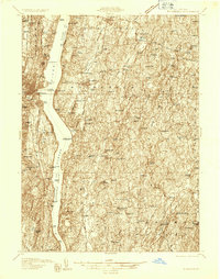 1934 Rhinebeck1934 Print · USGSDutchess and Ulster Counties meet along the Hudson River during the mid-1930s as the rail and river economy persists. Researchers can locate river landmarks like the Astor Tunnel and Kingston Point, or trace local roots at the Quaker Meeting House and Stone Church.2 unique versions available
 - 1934 Map of Catskill, 1960 Print
 1934 Catskill1960 Print · USGSThe Hudson Valley during the mid-1930s shows a landscape of riverfront commerce and deep-rooted rural townships. Genealogists and local historians can locate country schools like Schuylerhook Sch and historic landmarks like the Birthplace of Robert Livingston.2 unique versions available
 - 1938 Map of Catskill
 1938 Catskill1938 Print · USGSThe Hudson Valley in the late thirties remains a landscape of river-side industry and deep colonial heritage. Researchers can trace family sites from Kiskatom Ch to the Birthplace of Robert Livingston or locate vanished local landmarks like Walker Mill.2 unique versions available
 - 1939 Map of Rhinebeck
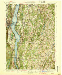 1939 Rhinebeck1939 Print · USGSDutchess and Ulster Counties flank the Hudson River in the late 1930s, revealing a landscape defined by riverside rail travel and rural hamlets. Genealogists can locate numerous local landmarks including Clinton Corners, Washington Hollow, and the Kingston Point Lighthouse.3 unique versions available
End of results
Showing maps 1-4 of 4
Top cities near Milan
- Kingston historical maps
- Hyde Park historical maps
- Saugerties historical maps
- Ulster historical maps
- Catskill historical maps
- Lloyd historical maps
See more
Top neighborhoods of Milan
Frequently asked questions
- What are the different types of historical maps available for Milan?
- What is the oldest map of Milan?
- Where can I purchase historical maps of Milan for my home or office?
- Where can I download high-res historical maps of Milan?
- Are there historical topographic maps available for Milan?
- Is there historical aerial imagery available for Milan?
- Where are historical maps of Milan sourced from?