Old Maps of Milan, New York for Academic Research
Study the evolution of Milan with 50 high-resolution historic maps. Whether you're teaching, researching, or modeling changes in land use, these maps provide essential visual documentation of urban, environmental, and geographic change.
- Analyze long-term change: Track patterns in development, transportation, and natural features.
- Ideal for environmental or urban studies: Support academic projects with primary historical map data.
- Use in the classroom or lab: Educators and researchers rely on these maps to bring historical context to life.
These maps are a powerful tool for teaching, research, and visualizing how Milan has changed over the decades.
Milan, NY maps
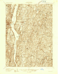
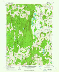
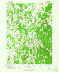
(50)- 1895 Map of Catskill
 1895 Catskill1895 Print · USGSThe Hudson River valley at the close of the 19th century was a landscape of bustling river ports and expanding rail lines. Genealogists and researchers can trace family lands near Saugerties, locate the old Burden Dock, or follow the route of the Catskill Mountain and Cairo R. R.10 unique versions available
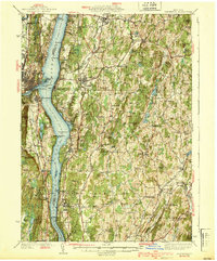
 - 1898 Map of Rhinebeck
 1898 Rhinebeck1898 Print · USGSThe Hudson River valley at the close of the nineteenth century was a bustling network of rail lines and river landings. Genealogists and historians can trace the foundations of Hyde Park, find the riverside Esopus Light, or locate rail junctions like Rhinecliff.9 unique versions available
 - 1899 Map of Millbrook, 1956 Print
 1899 Millbrook1956 Print · USGSDutchess County enters a period of high rail connectivity in the late nineteenth century, as iron and agriculture drive local growth. Genealogists and historians can trace the paths of four railroads through hamlets like Millerton, Bangall, and Amenia Union.
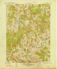
 - 1902 Map of Millbrook
 1902 Millbrook1902 Print · USGSEastern Dutchess County at the turn of the century was a bustling corridor of intersecting railroads and valley settlements. Genealogists and rail historians can trace the paths of the Central New England R. R. and find local landmarks like Lithgow, Shekomeko, and Hammertown.10 unique versions available
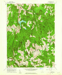
 - 1902 Map of Copake, 1954 Print
 1902 Copake1954 Print · USGSColumbia County at the turn of the century shows a landscape defined by industry and iron, before modern highways bypassed these hillside hamlets. Trace the rail-and-mine economy through Copake Ironworks, the Weed Mines, and the busy junction at Boston Corners.
 - 1904 Map of Copake
 1904 Copake1904 Print · USGSColumbia County at the turn of the century shows a landscape defined by deep-rooted industry and an extensive rail network. Researchers can trace the legacy of mining and milling at Ancram Leadmines, Weed Mines, and the Spaulding Furnace along the Roeliff Jansen Kill.7 unique versions available
 - 1934 Map of Rhinebeck
 1934 Rhinebeck1934 Print · USGSDutchess and Ulster Counties meet along the Hudson River during the mid-1930s as the rail and river economy persists. Researchers can locate river landmarks like the Astor Tunnel and Kingston Point, or trace local roots at the Quaker Meeting House and Stone Church.2 unique versions available
 - 1934 Map of Catskill, 1960 Print
 1934 Catskill1960 Print · USGSThe Hudson Valley during the mid-1930s shows a landscape of riverfront commerce and deep-rooted rural townships. Genealogists and local historians can locate country schools like Schuylerhook Sch and historic landmarks like the Birthplace of Robert Livingston.2 unique versions available
 - 1938 Map of Catskill
 1938 Catskill1938 Print · USGSThe Hudson Valley in the late thirties remains a landscape of river-side industry and deep colonial heritage. Researchers can trace family sites from Kiskatom Ch to the Birthplace of Robert Livingston or locate vanished local landmarks like Walker Mill.2 unique versions available
 - 1939 Map of Rhinebeck
 1939 Rhinebeck1939 Print · USGSDutchess and Ulster Counties flank the Hudson River in the late 1930s, revealing a landscape defined by riverside rail travel and rural hamlets. Genealogists can locate numerous local landmarks including Clinton Corners, Washington Hollow, and the Kingston Point Lighthouse.3 unique versions available
 - 1941 Map of Catskill, 1945 Print
 1941 Catskill1945 Print · USGSThe Hudson River valley at the start of the Second World War shows a landscape defined by historic estates and new river crossings. Genealogists and historians can trace the foundations of Bard College, locate the Birthplace of Robert Livingston, and explore early hamlets like Katsbaan and Cheviot.
 - 1947 Map of Hartford, 1955 Print
 1947 Hartford1955 Print · USGSSouthern New England and the Hudson Valley are shown in detail during the post-war expansion era. Genealogists and researchers can trace local landmarks from the State Capitol and Yale University to the Stratford Lighthouse and Woodlawn Cem.2 unique versions available
 - 1948 Map of Ancram
 1948 Ancram1948 Print · USGSColumbia County in the late 1940s remained a landscape of dispersed hamlets and rural school districts. Researchers can trace historic industry at Spaulding Furnace and locate family landmarks like Vedder Ch, Silvernails, and New Forge.2 unique versions available
 - 1948 Map of Hartford
 1948 Hartford1948 Print · USGSSouthern New England is captured here in the late 1940s, showcasing a landscape of thriving industrial cities and developing parkways. Genealogists and historians can trace the rail networks of the New York New Haven and Hartford RR or locate coastal defense sites like Fort Terry and Camp Shanks.2 unique versions available
 - 1948 Map of Pine Plains
 1948 Pine Plains1948 Print · USGSMid-century Dutchess County is captured here in a moment of quiet transition, showing the rural landscape before modern development. Genealogists can locate family-named landmarks like Pachin Mills, Old Attlebury, and rural schoolhouses such as Bear Market Sch.
 - 1948 Map of Albany, 1951 Print
 1948 Albany1951 Print · USGSThe Hudson and Connecticut River valleys are captured here in the late 1940s, showing the vital rail and water corridors of the Northeast. You can trace the Boston and Maine tracks past Mt Greylock or locate early settlements like Great Barrington and Bennington.
 - 1956 Map of Albany, 1968 Print
 1956 Albany1968 Print · USGSThe industrial heart of the Northeast is revealed in the mid-1950s, from the Hudson Valley to the Connecticut River. Researchers can trace the legacy of the Quabbin Reservoir, locate Westover Air Force Base, or follow the Rutland RR through the Green Mountains.2 unique versions available
 - 1957 Map of Albany
 1957 Albany1957 Print · USGSThe Tri-State region and Connecticut River Valley are captured here during a period of significant postwar growth and infrastructure expansion. Genealogists and historians can trace the rail-and-river economy through landmarks like the Boston and Maine railroad, Quabbin Reservoir, and Westover Air Force Base.
 - 1959 Map of Albany
 1959 Albany1959 Print · USGSThe Hudson and Connecticut River valleys are captured here during the late fifties, showing the region's dense rail networks and massive water projects. Researchers can trace the New York State Thruway or locate local landmarks like Mt Greylock and the Quabbin Reservoir.
 - 1960 Map of Ancram, 1962 Print
 1960 Ancram1962 Print · USGSColumbia and Dutchess County rural life is detailed here as it stood in the early sixties, centered on the historic settlements and waterways of the Hudson Highlands. Genealogists and historians can trace family locations near Ancram Union Cem or locate old industrial sites like Spaulding Furnace and New Forge.4 unique versions available
 - 1960 Map of Pine Plains, 1963 Print
 1960 Pine Plains1963 Print · USGSNorthern Dutchess County remains a landscape of glacial lakes and mountain ridges in the early sixties. Genealogists and local historians can trace family-named sites like Conklin Hill or locate the Church of the Regeneration and Evergreen Cem in Pine Plains.4 unique versions available
 - 1961 Map of Hartford
 1961 Hartford1961 Print · USGSSouthern New England and the Hudson Valley are shown here in the mid-fifties, capturing a landscape of booming coastal cities and interior hill towns. Researchers can trace the legacy of the New York New Haven and Hartford rail corridor and find strategic sites like Camp Shanks and Fort Michie.
 - 1962 Map of Albany
 1962 Albany1962 Print · USGSThe Hudson and Connecticut River valleys meet the Green Mountains and Berkshires in this mid-century overview of the Northeast. Genealogists and historians can trace the industrial hearts of Albany and Springfield or locate features like Quabbin Reservoir and Westover Air Force Base.
 - 1962 Map of Hartford, 1971 Print
 1962 Hartford1971 Print · USGSSouthern New England and the Hudson Valley are shown in the early sixties, as suburban growth reached into the foothills. Trace the path of the New York New Haven & Hartford RR and find landmarks like Camp Nathan Hale and Gillette Castle State Park.3 unique versions available
 - 1963 Map of Clermont, 1964 Print
 1963 Clermont1964 Print · USGSThe Columbia and Dutchess County line comes to life in the early sixties as a region of winding kills and crossroads hamlets. Genealogists and historians can trace family-named sites like Bingham Mills, Cokertown, and St Johns Ch.4 unique versions available
Showing maps 1-25 of 50
Top cities near Milan
- Kingston historical maps
- Hyde Park historical maps
- Saugerties historical maps
- Ulster historical maps
- Catskill historical maps
- Lloyd historical maps
See more
Top neighborhoods of Milan
Frequently asked questions
- What are the different types of historical maps available for Milan?
- What is the oldest map of Milan?
- Where can I purchase historical maps of Milan for my home or office?
- Where can I download high-res historical maps of Milan?
- Are there historical topographic maps available for Milan?
- Is there historical aerial imagery available for Milan?
- Where are historical maps of Milan sourced from?