1940s Maps of Erie County, New York
Explore 23 historic maps of Erie County from the 1940s. These maps offer a rare glimpse into what life looked like during the 1940s — showing old roads, neighborhoods, homes, and landmarks that have changed or disappeared over time.
Whether you're researching your family's past, planning a metal detecting trip, or studying how Erie County's landscape evolved across the 1940s, these high-resolution maps are a powerful tool for exploring the history of this region.
- Focus on a specific era: All maps on this page are from the 1940s, giving you a focused view of this time period.
- See what’s changed: Compare century-old streets, trails, and buildings to today's modern landscape using overlays and satellite layers.
- Research with precision: Use these maps for genealogy, historical research, land use analysis, or educational projects.
- View, download, or print: Maps are fully viewable online in high resolution, and can be downloaded or printed for your own records.
Start exploring Erie County's history through authentic maps from the 1940s. This is your window into the past.
Erie County, NY maps
(23)- 1941 Map of Cattaraugus
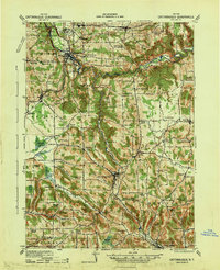 1941 Cattaraugus1941 Print · USGSWestern New York’s rural townships are captured here just before the mid-century, from the Cattaraugus Indian Reservation to the valley of Little Valley. Genealogists can trace dozens of early schoolhouses and local hamlets like Bagdad, Eddyville, and Five Points.
 - 1941 Map of Ellicottville
 1941 Ellicottville1941 Print · USGSCattaraugus County in the early 1940s is shown here as a landscape of rural school districts and rail-side villages. Researchers can trace the Baltimore and Ohio tracks through Riceville Sta or locate family sites near Dutch Hill Church and Fancy Tract.
 - 1943 Map of Silver Creek, 1953 Print
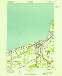 1943 Silver Creek1953 Print · USGSThe Lake Erie shoreline in Chautauqua County comes alive in this mid-century survey, showcasing a bustling rail corridor and beachside communities. Genealogists can trace family roots near Silver Creek, Hanover Center, or the Cattaraugus Indian Reservation.
 - 1944 Map of Eden
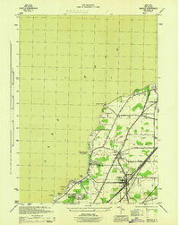
 1944 Eden1944 Print · USGSCoastal Lake Erie and the inland valleys of Erie County are seen here during the mid-1940s. Genealogists can trace family footprints through the Cattaraugus Indian Reservation or old rail stops like Idlewood Sta and Lawton Sta.
 - 1944 Map of North Collins
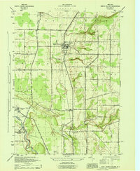 1944 North Collins1944 Print · USGSSouthern Erie County is captured here in the mid-1940s, showing the intersection of rail infrastructure and the rural landscape. Genealogists can trace family locations along Mile Strip Road and explore sites like the Thomas Indian School or the Cem near North Collins.
 - 1944 Map of Hamburg
 1944 Hamburg1944 Print · USGSHamburg and its surrounding valleys are captured here during the mid-1940s as the regional landscape balanced industry and recreation. Genealogists can trace family footprints near Eden Valley or explore the early layout of the Erie County Fairgrounds and Chestnut Ridge Park.
 - 1944 Map of Angola
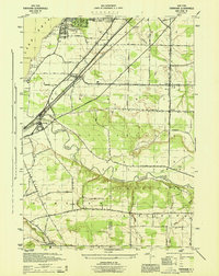
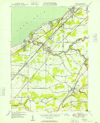
 1944 Angola1944 Print · USGSCoastal Erie County at the height of the war shows a landscape of busy rail corridors and growing lakeshore retreats. Trace the historic paths of the Pennsylvania and New York Central railroads as they pass through Angola and Jerusalem Corners.
 - 1944 Map of Farnham
 1944 Farnham1944 Print · USGSWestern New York at the height of the war years shows a landscape of busy rail corridors and developing lakeside communities. Genealogists and local historians can trace family locations near Farnham, the borders of the Cattaraugus Indian Reservation, and the small settlement of Smiths Mills.
 - 1944 Map of Langford
 1944 Langford1944 Print · USGSSouthern Erie County is captured here in the mid-1940s, showing a landscape of established farmsteads and rural crossroads communities. Researchers can trace family names and small settlements such as New Oregon, Clarksburg, and the state hospital reservoir near Marshfield.
 - 1944 Map of Silver Creek
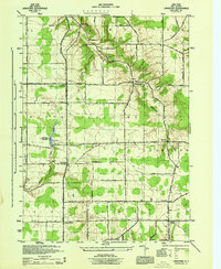
 1944 Silver Creek1944 Print · USGSThe Lake Erie shoreline in the mid-1940s was a landscape defined by seasonal beach colonies and heavy rail traffic. Genealogists and historians can trace old homesteads along Old Forestville Road or explore the early layout of the Cattaraugus Indian Reservation and Silver Creek Airport.
 - 1948 Map of Hamburg
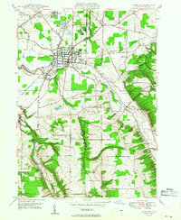 1948 Hamburg1948 Print · USGSSouthern Erie County was a mix of bustling rail hubs and rural dairy country just after the war. You can trace the path of the Erie RR through Hamburg, or locate family landmarks like the Erie County Fairgrounds and Chestnut Ridge Park.
 - 1948 Map of Depew, 1953 Print
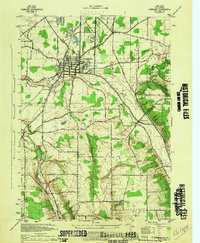
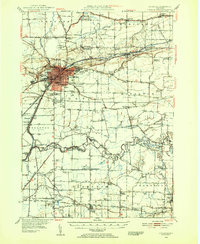
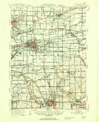 1948 Depew1953 Print · USGSErie County's industrial and civic heart comes into focus during this post-war era of rail and aviation expansion. Researchers can trace ancestral roots at Clarence Fillmore Cemetery or locate old schoolhouses like School No 1 and School No 8 across Harris Hill and Marilla.3 unique versions available
 - 1948 Map of Tonawanda, 1953 Print
 1948 Tonawanda1953 Print · USGSNiagara and Erie counties are shown here just after the war, where the Niagara River meets the historic Erie Canal. Genealogists and local historians can trace the early layout of North Tonawanda or locate family sites at Molyneaux Corners and Colonial Village.3 unique versions available
 - 1948 Map of Lockport, 1953 Print
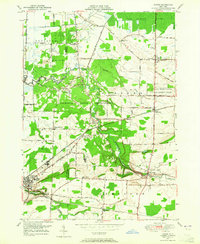
 1948 Lockport1953 Print · USGSNiagara and Erie Counties are shown here during the late forties, when the canal and rail lines still anchored the regional economy. Researchers can locate numerous numbered rural schoolhouses and vanished stops like Hodgeville Sta or Akron Junction.3 unique versions available
 - 1948 Map of Tonawanda West, 1958 Print
 1948 Tonawanda West1958 Print · USGSThe industrial and riverfront character of the Niagara frontier is on full display during the postwar era. Genealogists and historians can trace rail networks like the New York Central RR and locate local landmarks such as Bishop Duffy High Sch or the Holy Ghost Cem (Church).2 unique versions available
 - 1948 Map of Buffalo, 1958 Print
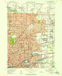
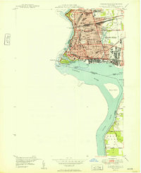
 1948 Buffalo1958 Print · USGSThe Niagara Frontier during the post-war boom years shows the industrial might of the riverfront and the rapid growth of its suburbs. Genealogists and historians can trace neighborhood developments from Brighton Village to Orchard Park, locating landmarks like St Stanislaus Cem and the early Buffalo Airport.
 - 1948 Map of Buffalo NE, 1958 Print
 1948 Buffalo NE1958 Print · USGSBuffalo and its northern reaches are shown in the late 1940s as suburban expansion meets a powerful industrial rail network. Genealogists and historians can trace thousands of individual property blocks and key local landmarks like Offerman Stadium, Forest Lawn Cemetery, and the University of Buffalo.
 - 1948 Map of Buffalo SE, 1959 Print
 1948 Buffalo SE1959 Print · USGSThe Lake Erie shoreline and Buffalo's industrial southern frontier are captured here just after the war. Local historians can trace the rail-heavy landscape of Lackawanna or locate family sites near the Basilica Of Our Lady Of Victory and St Matthews Cem.
 - 1949 Map of Eden
 1949 Eden1949 Print · USGSCoastal Erie County and the agricultural townships of Hamburg and Eden are captured here in the late 1940s. Genealogists and local historians can trace the rail corridors of the Pennsylvania railroad and early lakefront developments like Wanakah and Highland-on-the-Lake.
 - 1949 Map of Niagara Falls
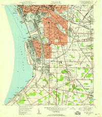
 1949 Niagara Falls1949 Print · USGSNiagara Falls at the close of the 1940s showcases a dense urban grid and international border long before modern redevelopment. Genealogists can trace family neighborhoods through sites like Oakwood Cem and Gaskill High Sch.
 - 1949 Map of Attica, 1953 Print
 1949 Attica1953 Print · USGSWestern New York at mid-century reveals a dense network of major railroads and rural hamlets across Genesee and Wyoming counties. Genealogists and historians can trace family locations through numerous numbered schools, named crossroads like Brick House Corners, and landmarks such as the Attica State Prison.
 - 1949 Map of Akron, 1965 Print
 1949 Akron1965 Print · USGSWestern New York at mid-century reveals a landscape shaped by indigenous heritage and rural development. Genealogists and historians can trace family-named roads and old rail stops like Basom and Pembroke Sta, or locate sites like the Council House and Evergreen Cem.
 - 1949 Map of Cowlesville, 1969 Print
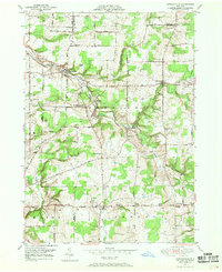 1949 Cowlesville1969 Print · USGSWyoming County's rural character is well-preserved here in the years following the war, showing a landscape defined by small crossroads hamlets and creek-side settlements. Genealogists can trace family roots through sites like Persons Corners, Persons Cem, and several numbered schoolhouses including School No 19.
End of results
Showing maps 1-23 of 23
Top cities of Erie County
- Buffalo historical maps
- Amherst historical maps
- Cheektowaga historical maps
- Tonawanda historical maps
- Hamburg historical maps
- West Seneca historical maps
See more
Frequently asked questions
- What are the different types of historical maps available for Erie County?
- What is the oldest map of Erie County?
- Where can I purchase historical maps of Erie County for my home or office?
- Where can I download high-res historical maps of Erie County?
- Are there historical topographic maps available for Erie County?
- Is there historical aerial imagery available for Erie County?
- Where are historical maps of Erie County sourced from?