Old Maps of Tonawanda, New York
Explore 27 old maps of Tonawanda, spanning from 1894 to today. These high-resolution historic maps reveal how streets, neighborhoods, landmarks, and natural features evolved over time — perfect for genealogy, metal detecting, research, and local history exploration.
What you can do with these maps:
- See how Tonawanda changed over time: Compare historical maps to modern-day views to trace roads, homesites, rail lines & more.
- View detailed metadata: Each map includes creators, publishers, year, scale, and archive source.
- Overlay maps with satellite & LiDAR: Visualize the past alongside modern tools to explore terrain & human change.
- Trusted historical sources: Maps sourced from the USGS, Library of Congress, and other archives.
- Access maps your way: View online, download high-res files, or order prints for personal or research use.
Start exploring old maps of Tonawanda to uncover forgotten places, hidden landmarks, and the deep history beneath your feet.
Tonawanda, NY maps
(27)- 1894 Map of Buffalo
 1894 Buffalo1894 Print · USGSCovers Tonawanda, including Buffalo, Amherst, and other nearby areas2 unique versions available
 - 1897 Map of Tonawanda
 1897 Tonawanda1897 Print · USGSCovers Tonawanda, including Amherst, Niagara Falls, and other nearby areas
 - 1899 Map of Niagara
 1899 Niagara1899 Print · USGSCovers Tonawanda, including Amherst, Niagara Falls, and other nearby areas6 unique versions available
 - 1900 Map of Tonawanda
 1900 Tonawanda1900 Print · USGSCovers Tonawanda, including Amherst, Niagara Falls, and other nearby areas
 - 1901 Map of Buffalo
 1901 Buffalo1901 Print · USGSCovers Tonawanda, including Buffalo, Amherst, and other nearby areas12 unique versions available
 - 1901 Map of Tonawanda
 1901 Tonawanda1901 Print · USGSCovers Tonawanda, including Amherst, Niagara Falls, and other nearby areas7 unique versions available
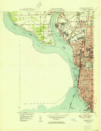
 - 1948 Map of Tonawanda, 1953 Print
 1948 Tonawanda1953 Print · USGSCovers Tonawanda, including Amherst, Niagara Falls, and other nearby areas3 unique versions available
 - 1948 Map of Tonawanda West, 1958 Print
 1948 Tonawanda West1958 Print · USGSCovers Tonawanda, including Niagara Falls, Niagara Falls, and other nearby areas2 unique versions available
 - 1948 Map of Buffalo, 1958 Print
 1948 Buffalo1958 Print · USGSCovers Tonawanda, including Buffalo, Amherst, and other nearby areas
 - 1950 Map of Buffalo NW
 1950 Buffalo NW1950 Print · USGSCovers Tonawanda, including Buffalo, Fort Erie, and other nearby areas2 unique versions available
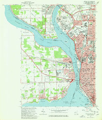
 - 1950 Map of Tonawanda East
 1950 Tonawanda East1950 Print · USGSCovers Tonawanda, including Amherst, North Tonawanda, and other nearby areas2 unique versions available
 - 1950 Map of Tonawanda West
 1950 Tonawanda West1950 Print · USGSCovers Tonawanda, including Niagara Falls, Niagara Falls, and other nearby areas
 - 1952 Map of Toronto, 1954 Print
 1952 Toronto1954 Print · USGSCovers Tonawanda, including Old Toronto, Mississauga, and other nearby areas
 - 1954 Map of Tonawanda West
 1954 Tonawanda West1954 Print · USGSCovers Tonawanda, including Niagara Falls, Niagara Falls, and other nearby areas
 - 1960 Map of Buffalo
 1960 Buffalo1960 Print · USGSCovers Tonawanda, including Buffalo, Amherst, and other nearby areas
 - 1962 Map of Buffalo, 1980 Print
 1962 Buffalo1980 Print · USGSCovers Tonawanda, including Buffalo, Amherst, and other nearby areas2 unique versions available
 - 1962 Map of Toronto, 1982 Print
 1962 Toronto1982 Print · USGSCovers Tonawanda, including Old Toronto, Mississauga, and other nearby areas
 - 1965 Map of Toronto
 1965 Toronto1965 Print · USGSCovers Tonawanda, including Old Toronto, Mississauga, and other nearby areas2 unique versions available
 - 1965 Map of Tonawanda West, 1967 Print
 1965 Tonawanda West1967 Print · USGSCovers Tonawanda, including Niagara Falls, Niagara Falls, and other nearby areas
 - 1965 Map of Buffalo NW, 1967 Print
 1965 Buffalo NW1967 Print · USGSCovers Tonawanda, including Buffalo, Fort Erie, and other nearby areas2 unique versions available
 - 1965 Map of Tonawanda East, 1967 Print
 1965 Tonawanda East1967 Print · USGSCovers Tonawanda, including Amherst, North Tonawanda, and other nearby areas
 - 1967 Map of Buffalo
 1967 Buffalo1967 Print · USGSCovers Tonawanda, including Buffalo, Amherst, and other nearby areas
 - 1973 Map of Buffalo
 1973 Buffalo1973 Print · USGSCovers Tonawanda, including Buffalo, Amherst, and other nearby areas
 - 1980 Map of Tonawanda West
 1980 Tonawanda West1980 Print · USGSCovers Tonawanda, including Niagara Falls, Niagara Falls, and other nearby areas
 - 1980 Map of Tonawanda East
 1980 Tonawanda East1980 Print · USGSCovers Tonawanda, including Amherst, North Tonawanda, and other nearby areas
Showing maps 1-25 of 27
Top cities near Tonawanda
- Buffalo historical maps
- Amherst historical maps
- Cheektowaga historical maps
- Tonawanda historical maps
- Hamburg historical maps
- Niagara Falls historical maps
See more
Frequently asked questions
- What are the different types of historical maps available for Tonawanda?
- What is the oldest map of Tonawanda?
- Where can I purchase historical maps of Tonawanda for my home or office?
- Where can I download high-res historical maps of Tonawanda?
- Are there historical topographic maps available for Tonawanda?
- Is there historical aerial imagery available for Tonawanda?
- Where are historical maps of Tonawanda sourced from?