1980s Maps of Essex County, New York
Explore 16 historic maps of Essex County from the 1980s. These maps offer a rare glimpse into what life looked like during the 1980s — showing old roads, neighborhoods, homes, and landmarks that have changed or disappeared over time.
Whether you're researching your family's past, planning a metal detecting trip, or studying how Essex County's landscape evolved across the 1980s, these high-resolution maps are a powerful tool for exploring the history of this region.
- Focus on a specific era: All maps on this page are from the 1980s, giving you a focused view of this time period.
- See what’s changed: Compare century-old streets, trails, and buildings to today's modern landscape using overlays and satellite layers.
- Research with precision: Use these maps for genealogy, historical research, land use analysis, or educational projects.
- View, download, or print: Maps are fully viewable online in high resolution, and can be downloaded or printed for your own records.
Start exploring Essex County's history through authentic maps from the 1980s. This is your window into the past.
Essex County, NY maps
(16)- 1980 Map of Willsboro
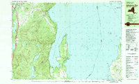
 1980 Willsboro1980 Print · USGSThe Lake Champlain shoreline at the edge of the Adirondacks was a bustling corridor of rail and water transport in the late twentieth century. Researchers can trace the Delaware and Hudson line between Willsboro and Essex, or locate family sites like Brookfield Cem and St Josephs Ch.
 - 1980 Map of Westport, 1981 Print
 1980 Westport1981 Print · USGSLake Champlain divides the New York Adirondacks from the Vermont plains in the early eighties, showing a landscape defined by water and rail. Researchers can trace family sites at Riverside Cem and Prospect Cem, or locate landmarks like Camp Dudley and the Delaware and Hudson railroad.3 unique versions available
 - 1980 Map of Port Henry, 1981 Print
 1980 Port Henry1981 Print · USGSLake Champlain's narrows were a hub of activity in the late twentieth century, balancing heavy industry with significant colonial heritage. Genealogists and historians can trace Fort St Frederic Ruins, family cemeteries like Spear Cem, and the path of the Delaware and Hudson railroad.
 - 1980 Map of Willsboro Bay, 1981 Print
 1980 Willsboro Bay1981 Print · USGSLake Champlain and the eastern edge of the Adirondacks meet in the early eighties, revealing a landscape of shoreline camps and mountain peaks. Trace the Delaware and Hudson rail line through Port Douglass or locate historic family spots near Highlands Forge Lake and Schuyler Island.2 unique versions available
 - 1985 Map of Tupper Lake, 1986 Print
 1985 Tupper Lake1986 Print · USGSThe Adirondacks in the mid-1980s reveal a network of mountain villages and timber-connected outposts. Researchers can trace the Adirondack RR through Saranac Lake or locate old industrial hamlets like Newton Falls and Gleasons Mill.2 unique versions available
 - 1985 Map of Raquette Lake, 1986 Print
 1985 Raquette Lake1986 Print · USGSThe central Adirondacks are documented here in the mid-1980s, showcasing the complex lake systems and early rail routes that defined the region. Researchers can trace historic landmarks like Sagamore, isolated stops along the Adirondack RR, and the remote layout of Old Forge.2 unique versions available
 - 1986 Map of Lake Champlain South
 1986 Lake Champlain South1986 Print · USGSIn the mid-1980s, the shores of Lake Champlain linked the Adirondack high peaks with the Vermont valley. Genealogists and researchers can trace the rail lines of the Delaware & Hudson RR or locate historic settlements like Mineville and Au Sable Forks.2 unique versions available
 - 1986 Map of Ticonderoga
 1986 Ticonderoga1986 Print · USGSThe Lake Champlain valley in the mid-eighties shows a landscape defined by Revolutionary War history and deep wilderness. Researchers can trace the Delaware and Hudson RR through the mountains or locate local landmarks like Fort Ticonderoga, St. Genevieve Cem, and the Ore Bed.
 - 1986 Map of Lake Champlain North
 1986 Lake Champlain North1986 Print · USGSThe Lake Champlain borderlands in the mid-1980s show a mix of mountain villages and busy island shorelines. Researchers can trace the Delaware and Hudson RR through Plattsburgh or locate old rural sites like Mooers Forks and St Josephs Cem.2 unique versions available
 - 1989 Map of Schroon Lake
 1989 Schroon Lake1989 Print · USGSThe Adirondack wilderness meets the developed shores of the lake in the late eighties, showing a balance of recreation and forest living. Researchers can find mountain settlements like Irishtown and Loch-Muller alongside recreational features like the Snowmobile Trail.2 unique versions available
 - 1989 Map of Deerland
 1989 Deerland1989 Print · USGSThe Adirondack wilderness of the late eighties is centered here on the long reach of Long Lake and its lakeside communities. Genealogists and hikers can trace local routes through Deerland, locate the Post Office, and find the Fire Lookout Tower on Owls Head Mountain.
 - 1989 Map of Blue Mtn Lake
 1989 Blue Mtn Lake1989 Print · USGSThe Central Adirondacks are captured here in the late 1980s, centered on the highland waters and timbered slopes of Hamilton County. Researchers can trace the development of Indian Lake and Blue Mountain Lake, locating local sites like the Forest House and Cem.
 - 1989 Map of Newcomb
 1989 Newcomb1989 Print · USGSThe Adirondack interior near Newcomb was a hub for environmental research and recreation in the late eighties. Researchers can trace the layout of the SUNY Newcomb Campus and shoreline landmarks like the Tahawus Club and Rich Lake.2 unique versions available
 - 1989 Map of Blue Ridge
 1989 Blue Ridge1989 Print · USGSThe Adirondack wilderness of Essex County in the late eighties reveals a landscape of high ridges and secluded glacial waters. Researchers can trace the drainage of the Boreas River and locate remote features like Hoffman Notch and the Foot Bridge.
 - 1989 Map of Ticonderoga
 1989 Ticonderoga1989 Print · USGSThe Champlain Valley and Adirondack foothills meet in the late eighties, documenting a historic borderland defined by mountain lakes and timber. Genealogists and historians can trace the paths of the Delaware and Hudson RR or locate the Hubbardton Battlefield State Historic Site.2 unique versions available
 - 1989 Map of Dutton Mountain
 1989 Dutton Mountain1989 Print · USGSThe Adirondack High Peaks region in the late 1980s reveals a landscape of protected wilderness and established mountain retreats. Trace the winding Hudson River through Minerva past historic sporting sites like the Gooley Club and Aiden Lair.
End of results
Showing maps 1-16 of 16
Top cities of Essex County
- North Elba historical maps
- Ticonderoga historical maps
- Moriah historical maps
- Jay historical maps
- Chesterfield historical maps
- Crown Point historical maps
See more
Frequently asked questions
- What are the different types of historical maps available for Essex County?
- What is the oldest map of Essex County?
- Where can I purchase historical maps of Essex County for my home or office?
- Where can I download high-res historical maps of Essex County?
- Are there historical topographic maps available for Essex County?
- Is there historical aerial imagery available for Essex County?
- Where are historical maps of Essex County sourced from?