Old Maps of Stillwater, Minerva for Genealogy
Trace your family roots with 16 historic maps of Stillwater. These high-res maps reveal old neighborhoods, homesites, landmarks, and streets — helping you uncover where your ancestors lived and how the area evolved over time.
- Explore historic neighborhoods: Identify where your relatives may have lived in the 1800s or 1900s.
- Compare maps over time: Trace the changes in streets, buildings, and landmarks for multi-generational research.
- Perfect for genealogy & ancestry research: Used by family historians and researchers to map out lineage and migration.
These maps are an incredible resource for exploring your personal connection to Stillwater's past.
Stillwater, Minerva maps
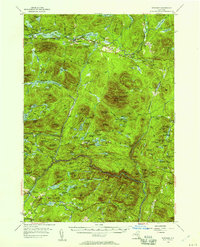
(16)- 1898 Map of Newcomb
 1898 Newcomb1898 Print · USGSThe Adirondack wilderness around the upper Hudson River is captured here in the late nineteenth century. Genealogists and historians can trace early settlements and sporting outposts like Aiden Lair, the Northwoods Club, and Tahawus.
 - 1901 Map of Newcomb
 1901 Newcomb1901 Print · USGSThe Adirondack high country near the turn of the century is defined by the headwaters of the Hudson River and the small outposts of the New York interior. Genealogists and historians can trace the early footprint of the Northwoods Club, the settlement at Newcomb, and the remote station at Aiden Lair.9 unique versions available
 - 1950 Map of Utica, 1951 Print
 1950 Utica1951 Print · USGSCentral New York in the post-war era showcases the industrial Mohawk Valley and the pristine Adirondack interior. Researchers can trace transportation networks like the New York Central Railroad and find early Cold War sites such as Griffiss Air Force Base.
 - 1954 Map of Newcomb, 1957 Print
 1954 Newcomb1957 Print · USGSThe High Peaks wilderness of Essex and Hamilton Counties is captured here in the mid-1950s, centered on the settlement of Newcomb. Researchers can trace the Old Military Road, locate the Tahawus Club, and identify mid-century retreats like Camp Che-na-wah and Aiden Lair.5 unique versions available
 - 1957 Map of Utica
 1957 Utica1957 Print · USGSCentral New York and the Adirondack foothills are captured here in the mid-fifties, showing a landscape defined by the Mohawk River corridor and the growing highway system. Genealogists and researchers can trace the rail lines of the New York Central and locate communities from Lowville to Gloversville.
 - 1962 Map of Utica
 1962 Utica1962 Print · USGSCentral New York and the Adirondack wilderness are captured here during the mid-century era of highway and industrial expansion. Genealogists and historians can trace the development of the New York State Thruway and local rail lines connecting Utica, Rome, and Gloversville.3 unique versions available
 - 1964 Map of Utica
 1964 Utica1964 Print · USGSCentral New York and the high wilderness of the Adirondacks are captured here during the post-war era of infrastructure expansion. Researchers can trace the development of the New York State Thruway alongside historic corridors like the Oneida Lake (Barge Canal Route) and the N. Y. Central railroad.
 - 1967 Map of Utica
 1967 Utica1967 Print · USGSCentral New York's industrial Mohawk Valley meets the Adirondack wilderness in the 1960s, showing the region's transition from manufacturing hubs to state-managed parklands. Trace historic settlements and sites like Griffiss Air Force Base, Colgate University, and the Lyons Falls Paper Mill.
 - 1985 Map of Raquette Lake, 1986 Print
 1985 Raquette Lake1986 Print · USGSThe central Adirondacks are documented here in the mid-1980s, showcasing the complex lake systems and early rail routes that defined the region. Researchers can trace historic landmarks like Sagamore, isolated stops along the Adirondack RR, and the remote layout of Old Forge.2 unique versions available
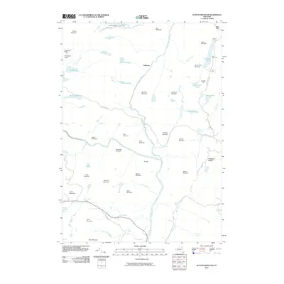
 - 1989 Map of Dutton Mountain
 1989 Dutton Mountain1989 Print · USGSThe Adirondack High Peaks region in the late 1980s reveals a landscape of protected wilderness and established mountain retreats. Trace the winding Hudson River through Minerva past historic sporting sites like the Gooley Club and Aiden Lair.
 - 1997 Map of Dutton Mountain, 2000 Print
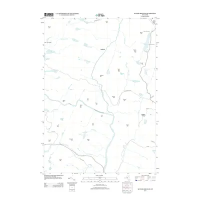
 1997 Dutton Mountain2000 Print · USGSAdirondack wilderness and private sporting clubs are documented during the late 1990s as the Hudson River winds through Essex County. Researchers can trace historic retreats and camps including Saints Rest, the Gooley Club, and Northern Frontier Camp.
 - 2010 Map of Dutton Mountain, 2010 Print
 2010 Dutton Mountain2010 Print · USGSCovers Stillwater, including Chester, Indian Lake, and other nearby areas
 - 2013 Map of Dutton Mountain, 2013 Print
 2013 Dutton Mountain2013 Print · USGSCovers Stillwater, including Chester, Indian Lake, and other nearby areas
 - 2016 Map of Dutton Mountain, 2016 Print
 2016 Dutton Mountain2016 Print · USGSCovers Stillwater, including Chester, Indian Lake, and other nearby areas
 - 2019 Map of Dutton Mountain, 2019 Print
 2019 Dutton Mountain2019 Print · USGSCovers Stillwater, including Chester, Indian Lake, and other nearby areas
 - 2023 Map of Dutton Mountain, 2023 Print
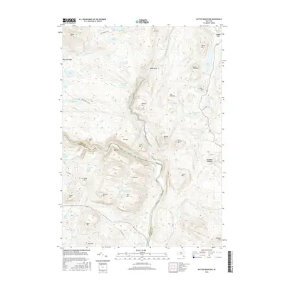
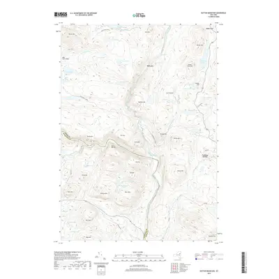
 2023 Dutton Mountain2023 Print · USGSThe Adirondack wilderness of Essex and Hamilton Counties is recorded here during the early twenty-first century. Researchers can trace the high-elevation drainage of the Hudson River and Boreas River or locate historic landmarks like Aiden Lair and Crusher Hill.
End of results
Showing maps 1-16 of 16
Top cities near Stillwater
- Warrensburg historical maps
- Chester historical maps
- Johnsburg historical maps
- Schroon historical maps
- Indian Lake historical maps
- Keene historical maps
See more
Frequently asked questions
- What are the different types of historical maps available for Stillwater?
- What is the oldest map of Stillwater?
- Where can I purchase historical maps of Stillwater for my home or office?
- Where can I download high-res historical maps of Stillwater?
- Are there historical topographic maps available for Stillwater?
- Is there historical aerial imagery available for Stillwater?
- Where are historical maps of Stillwater sourced from?