1970s Maps of Newcomb, New York
Explore 5 historic maps of Newcomb from the 1970s. These maps offer a rare glimpse into what life looked like during the 1970s — showing old roads, neighborhoods, homes, and landmarks that have changed or disappeared over time.
Whether you're researching your family's past, planning a metal detecting trip, or studying how Newcomb's landscape evolved across the 1970s, these high-resolution maps are a powerful tool for exploring the history of this region.
- Focus on a specific era: All maps on this page are from the 1970s, giving you a focused view of this time period.
- See what’s changed: Compare century-old streets, trails, and buildings to today's modern landscape using overlays and satellite layers.
- Research with precision: Use these maps for genealogy, historical research, land use analysis, or educational projects.
- View, download, or print: Maps are fully viewable online in high resolution, and can be downloaded or printed for your own records.
Start exploring Newcomb's history through authentic maps from the 1970s. This is your window into the past.
Newcomb, NY maps
(5)- 1978 Map of Ampersand Lake, 1979 Print
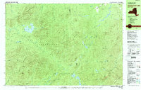 1978 Ampersand Lake1979 Print · USGSThe High Peaks wilderness in the late seventies is captured here at the junction of Franklin and Essex Counties. Outdoor historians and researchers can trace the Northville Placid Trail to landmarks like Wanika Falls Shelter, Duck Hole, and the peaks of Seward Mountain.2 unique versions available
 - 1979 Map of Kempshall Mtn
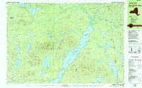 1979 Kempshall Mtn1979 Print · USGSThe central Adirondack wilderness comes alive in the late seventies, focused on the deep waters of Long Lake. Trace the primitive Northville Placid Trail past remote landmarks like the Lookout Tower and Shattuck Clearing.2 unique versions available
 - 1979 Map of Keene Valley
 1979 Keene Valley1979 Print · USGSThe High Peaks region during the late seventies reveals a landscape prepared for world-class competition. Trace family sites at Norton Cem and Olympic history at the Luge Run or Mt Van Hoevenberg Recreational Center.2 unique versions available
 - 1979 Map of Santanoni Peak
 1979 Santanoni Peak1979 Print · USGSThe High Peaks wilderness meets industrial history in the late seventies near the Santanoni Mountains. Researchers can locate the Old MacIntyre Furnace, trace the Northville Placid Trail, and see the footprint of the Tahawus mining operations.
 - 1979 Map of Mount Marcy
 1979 Mount Marcy1979 Print · USGSThe High Peaks wilderness is captured in the late seventies, showing the intricate trail and waterway systems surrounding the state's highest point. Hikers and historians can trace routes like the Guide Board Trail or locate remote spots like Marcy Landing and the Boreas Ponds.
End of results
Showing maps 1-5 of 5
Top cities near Newcomb
- North Elba historical maps
- Harrietstown historical maps
- Chester historical maps
- Schroon historical maps
- Indian Lake historical maps
- Keene historical maps
See more
Frequently asked questions
- What are the different types of historical maps available for Newcomb?
- What is the oldest map of Newcomb?
- Where can I purchase historical maps of Newcomb for my home or office?
- Where can I download high-res historical maps of Newcomb?
- Are there historical topographic maps available for Newcomb?
- Is there historical aerial imagery available for Newcomb?
- Where are historical maps of Newcomb sourced from?