1990s Maps of Saint Armand, New York
Explore 3 historic maps of Saint Armand from the 1990s. These maps offer a rare glimpse into what life looked like during the 1990s — showing old roads, neighborhoods, homes, and landmarks that have changed or disappeared over time.
Whether you're researching your family's past, planning a metal detecting trip, or studying how Saint Armand's landscape evolved across the 1990s, these high-resolution maps are a powerful tool for exploring the history of this region.
- Focus on a specific era: All maps on this page are from the 1990s, giving you a focused view of this time period.
- See what’s changed: Compare century-old streets, trails, and buildings to today's modern landscape using overlays and satellite layers.
- Research with precision: Use these maps for genealogy, historical research, land use analysis, or educational projects.
- View, download, or print: Maps are fully viewable online in high resolution, and can be downloaded or printed for your own records.
Start exploring Saint Armand's history through authentic maps from the 1990s. This is your window into the past.
Saint Armand, NY maps
(3)- 1999 Map of Lake Placid, 2001 Print
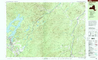 1999 Lake Placid2001 Print · USGSLake Placid at the end of the twentieth century shows a landscape defined by Olympic legacy and abolitionist history. Trace the grounds of the John Brown Farm or locate athletic landmarks like the Olympic Ski Jumps and Olympic Arena.
 - 1999 Map of Saranac Lake, 2001 Print
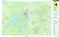 1999 Saranac Lake2001 Print · USGSThe Adirondacks at the close of the twentieth century show a landscape of high-peaks recreation and deep-seated village life. Researchers can trace the layout of Saranac Lake, finding sites like Pine Ridge Cem, Petrova High Sch, and the Olympic Village at Ray Brook.
 - 1999 Map of Bloomingdale, 2001 Print
 1999 Bloomingdale2001 Print · USGSThe northern Adirondack high country is shown in the late 1990s, centering on the communities of Bloomingdale and Vermontville. Trace local history at Paul Smiths College or find family roots at Mountain View Cemetery and St Pauls Cem.
End of results
Showing maps 1-3 of 3
Top cities near Saint Armand
- North Elba historical maps
- Harrietstown historical maps
- Saranac Lake historical maps
- Saranac historical maps
- Jay historical maps
- Lake Placid historical maps
See more
Top neighborhoods of Saint Armand
Frequently asked questions
- What are the different types of historical maps available for Saint Armand?
- What is the oldest map of Saint Armand?
- Where can I purchase historical maps of Saint Armand for my home or office?
- Where can I download high-res historical maps of Saint Armand?
- Are there historical topographic maps available for Saint Armand?
- Is there historical aerial imagery available for Saint Armand?
- Where are historical maps of Saint Armand sourced from?