1950s Maps of Arietta, New York
Explore 8 historic maps of Arietta from the 1950s. These maps offer a rare glimpse into what life looked like during the 1950s — showing old roads, neighborhoods, homes, and landmarks that have changed or disappeared over time.
Whether you're researching your family's past, planning a metal detecting trip, or studying how Arietta's landscape evolved across the 1950s, these high-resolution maps are a powerful tool for exploring the history of this region.
- Focus on a specific era: All maps on this page are from the 1950s, giving you a focused view of this time period.
- See what’s changed: Compare century-old streets, trails, and buildings to today's modern landscape using overlays and satellite layers.
- Research with precision: Use these maps for genealogy, historical research, land use analysis, or educational projects.
- View, download, or print: Maps are fully viewable online in high resolution, and can be downloaded or printed for your own records.
Start exploring Arietta's history through authentic maps from the 1950s. This is your window into the past.
Arietta, NY maps
(8)- 1950 Map of Utica, 1951 Print
 1950 Utica1951 Print · USGSCentral New York in the post-war era showcases the industrial Mohawk Valley and the pristine Adirondack interior. Researchers can trace transportation networks like the New York Central Railroad and find early Cold War sites such as Griffiss Air Force Base.
 - 1954 Map of Lake Pleasant, 1957 Print
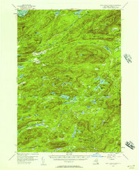
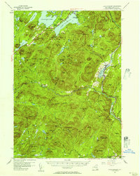 1954 Lake Pleasant1957 Print · USGSMid-century Hamilton County comes alive in this survey of the Lake Pleasant and Sacandaga Lake wilderness. Genealogists and researchers can trace the roads to Speculator, locate the Piseco Sch, or find remote landmarks like Whitehouse.6 unique versions available
 - 1954 Map of Blue Mountain, 1957 Print
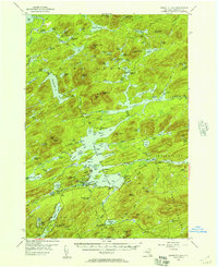
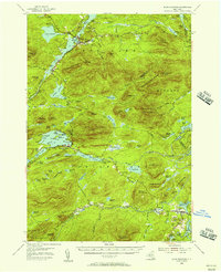 1954 Blue Mountain1957 Print · USGSIn the mid-1950s, this Adirondack landscape centers on the growing recreational hubs of Long Lake and Blue Mountain Lake. Genealogists and hikers can trace the Northville-Lake Placid Trail past the Long Lake Cem and the remote Forest House.6 unique versions available
 - 1954 Map of Piseco Lake, 1957 Print
 1954 Piseco Lake1957 Print · USGSMid-century Hamilton County is captured here in detail, showcasing the high-elevation settlements and lakes of the southern Adirondacks. Genealogists and historians can trace family locations and remote sites like Morehouseville, Shaker Place, and the Spruce Hill Cem.5 unique versions available
 - 1954 Map of Indian Lake, 1957 Print
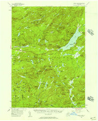
 1954 Indian Lake1957 Print · USGSThe Adirondack wilderness of the mid-fifties is centered here around the long reach of INDIAN LAKE. Researchers can trace old mountain routes like Military Road or locate remote outposts such as Perkins Clearing, Sabael, and the Snowy Mountain Lookout Tower.6 unique versions available
 - 1954 Map of West Canada Lakes, 1957 Print
 1954 West Canada Lakes1957 Print · USGSHamilton County's backcountry is captured here in the mid-1950s, showing a landscape of sporting camps and early hiking trails. Researchers can trace the path of the Northville Lake Placid Trail through Kenwells, Millers Camp, and the heights of Wakely Mountain.4 unique versions available
 - 1954 Map of Raquette Lake, 1957 Print
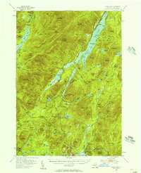
 1954 Raquette Lake1957 Print · USGSDeep in the Adirondack Park during the mid-fifties, this survey reveals the remote settlements and intricate waterways of the central New York wilderness. Genealogists and historians can trace local landmarks like St Williams Ch, the Raquette Lake Sch, and family-named features such as Antlers Point.5 unique versions available
 - 1957 Map of Utica
 1957 Utica1957 Print · USGSCentral New York and the Adirondack foothills are captured here in the mid-fifties, showing a landscape defined by the Mohawk River corridor and the growing highway system. Genealogists and researchers can trace the rail lines of the New York Central and locate communities from Lowville to Gloversville.
End of results
Showing maps 1-8 of 8
Top cities near Arietta
- Indian Lake historical maps
- Ohio historical maps
- Lake Pleasant historical maps
- Long Lake historical maps
- Wells historical maps
- Speculator historical maps
See more
Top neighborhoods of Arietta
- Higgins Bay historical maps
- Piseco historical maps
- Averys Place historical maps
- Powley Place historical maps
- Rudeston historical maps
- Shaker Place historical maps
Frequently asked questions
- What are the different types of historical maps available for Arietta?
- What is the oldest map of Arietta?
- Where can I purchase historical maps of Arietta for my home or office?
- Where can I download high-res historical maps of Arietta?
- Are there historical topographic maps available for Arietta?
- Is there historical aerial imagery available for Arietta?
- Where are historical maps of Arietta sourced from?