1980s Maps of Arietta, New York
Explore 6 historic maps of Arietta from the 1980s. These maps offer a rare glimpse into what life looked like during the 1980s — showing old roads, neighborhoods, homes, and landmarks that have changed or disappeared over time.
Whether you're researching your family's past, planning a metal detecting trip, or studying how Arietta's landscape evolved across the 1980s, these high-resolution maps are a powerful tool for exploring the history of this region.
- Focus on a specific era: All maps on this page are from the 1980s, giving you a focused view of this time period.
- See what’s changed: Compare century-old streets, trails, and buildings to today's modern landscape using overlays and satellite layers.
- Research with precision: Use these maps for genealogy, historical research, land use analysis, or educational projects.
- View, download, or print: Maps are fully viewable online in high resolution, and can be downloaded or printed for your own records.
Start exploring Arietta's history through authentic maps from the 1980s. This is your window into the past.
Arietta, NY maps
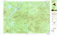
(6)- 1985 Map of Gloversville, 1986 Print
 1985 Gloversville1986 Print · USGSThe southern Adirondacks meet the Mohawk Valley industrial corridor during the mid-eighties, showcasing a landscape of high-country lakes and riverside manufacturing towns. Trace the historical alignment of the Erie Canal and Conrail lines or locate landmarks like the Herkimer Home State Historic Site.2 unique versions available
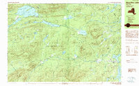
 - 1985 Map of Raquette Lake, 1986 Print
 1985 Raquette Lake1986 Print · USGSThe central Adirondacks are documented here in the mid-1980s, showcasing the complex lake systems and early rail routes that defined the region. Researchers can trace historic landmarks like Sagamore, isolated stops along the Adirondack RR, and the remote layout of Old Forge.2 unique versions available
 - 1989 Map of Deerland
 1989 Deerland1989 Print · USGSThe Adirondack wilderness of the late eighties is centered here on the long reach of Long Lake and its lakeside communities. Genealogists and hikers can trace local routes through Deerland, locate the Post Office, and find the Fire Lookout Tower on Owls Head Mountain.
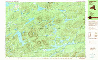
 - 1989 Map of Blue Mtn Lake
 1989 Blue Mtn Lake1989 Print · USGSThe Central Adirondacks are captured here in the late 1980s, centered on the highland waters and timbered slopes of Hamilton County. Researchers can trace the development of Indian Lake and Blue Mountain Lake, locating local sites like the Forest House and Cem.
 - 1989 Map of Forked Lake
 1989 Forked Lake1989 Print · USGSHamilton County in the late eighties remains a preserved wilderness of glacial ponds and mountain peaks within the Adirondack Park. Researchers can locate seasonal outposts like Deerland Camp and trace remote waterways from Lake Lila to the slopes of Antediluvian Mountain.2 unique versions available
 - 1989 Map of Raquette Lake
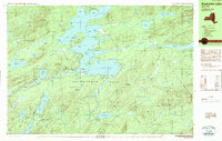 1989 Raquette Lake1989 Print · USGSHamilton County's waterways are captured here in the late 1980s, showcasing the intricate shoreline of the Adirondack Park. Local historians can trace the footprints of Great Camps at Sagamore and Pine Knot Point or locate the Raquette Lake Reservoir.2 unique versions available
End of results
Showing maps 1-6 of 6
Top cities near Arietta
- Indian Lake historical maps
- Ohio historical maps
- Lake Pleasant historical maps
- Long Lake historical maps
- Wells historical maps
- Speculator historical maps
See more
Top neighborhoods of Arietta
- Higgins Bay historical maps
- Piseco historical maps
- Averys Place historical maps
- Powley Place historical maps
- Rudeston historical maps
- Shaker Place historical maps
Frequently asked questions
- What are the different types of historical maps available for Arietta?
- What is the oldest map of Arietta?
- Where can I purchase historical maps of Arietta for my home or office?
- Where can I download high-res historical maps of Arietta?
- Are there historical topographic maps available for Arietta?
- Is there historical aerial imagery available for Arietta?
- Where are historical maps of Arietta sourced from?