Old Maps of Arietta, New York for Metal Detecting
Plan your next treasure hunt with 145 historic maps of Arietta. Find old homesites, ghost towns, trails, and gathering spots that may be lost to time — perfect for identifying promising metal detecting locations.
- Locate forgotten sites: Uncover places like long-lost settlements, abandoned rail lines, or gathering spots.
- Plan better hunts: Use map overlays combined with LiDAR or satellite views to narrow in on historically rich areas.
- Made for detectorists: Thousands of hobbyists use these maps to discover relics, coins, and hidden history.
Use these historic maps to boost your research and find new opportunities beneath the surface of Arietta.
Arietta, NY maps
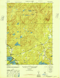
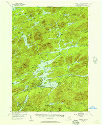
(145)- 1899 Map of Indian Lake
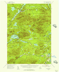
 1899 Indian Lake1899 Print · USGSHamilton County was a landscape of remote wilderness camps and logging waters at the turn of the century. You can trace early backcountry outposts like Camp Comfort and Camp Perkins or locate landmarks like Wakely Dam and the settlement of Speculator.
 - 1900 Map of Canada Lake
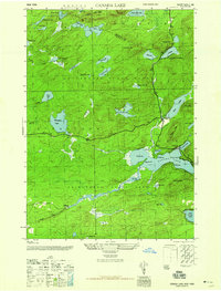
 1900 Canada Lake1900 Print · USGSHamilton County was a remote wilderness of lakes and high peaks at the turn of the century. Genealogists and historians can locate early outposts like Kenwells and Northrup Lodge or trace the original shorelines of West Canada Lake.
 - 1901 Map of Lassellsville, 1959 Print
 1901 Lassellsville1959 Print · USGSFulton and Montgomery Counties come alive in this turn-of-the-century survey of the Mohawk Valley and southern Adirondacks. Genealogists and researchers can pinpoint family holdings near Irish Settlement, the industry of Newkirk Mills, and the rails of the N. Y. C. and H. R. R. R.
 - 1902 Map of Indian Lake
 1902 Indian Lake1902 Print · USGSHamilton County at the turn of the century shows a wilderness of high peaks and sprawling waterways before the era of modern development. Researchers can trace early Adirondack outposts like Camp Perkins or locate the village of Speculator and the Hatchery on Whiskey Brook.9 unique versions available
 - 1903 Map of West Canada Lakes
 1903 West Canada Lakes1903 Print · USGSHamilton County was a landscape of remote sporting camps and high Adirondack peaks at the turn of the century. Genealogists and researchers can trace early outposts like Kenwells and Millers Camp among landmarks such as Seventh Lake and Wakely Mt.10 unique versions available
 - 1903 Map of Gloversville
 1903 Gloversville1903 Print · USGSGloversville and Johnstown anchor this turn-of-the-century survey as the region's industrial heart, surrounded by the growing Adirondack resort and timber lands. Genealogists and historians can trace the Electric R.R. or locate historic markers like the Battle Monument and old hamlets like Bleecker Center.8 unique versions available
 - 1903 Map of Lassellsville
 1903 Lassellsville1903 Print · USGSFulton County at the start of the century shows a landscape of upland mill sites and busy valley railroads. Genealogists can trace family names at Irish Settlement, Fical Corners, and the mill sites at Newkirk Mills.6 unique versions available
 - 1903 Map of Raquette Lake
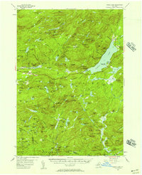
 1903 Raquette Lake1903 Print · USGSThe Adirondack wilderness of Hamilton County is captured here at the turn of the century, showing a remote landscape of high peaks and vast waterways. Researchers can trace early seasonal outposts like Hasbroucks and St. Hubert I. or follow the historic STEAMBOAT ROUTE across Raquette Lake.13 unique versions available
 - 1903 Map of Blue Mountain
 1903 Blue Mountain1903 Print · USGSThe Adirondack wilderness in the early 1900s centered on the waterways of Hamilton County. Trace the early tourism routes including the Steamboat Route through Blue Mountain Lake and historical stops like Forest House.11 unique versions available
 - 1904 Map of Piseco Lake
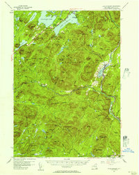
 1904 Piseco Lake1904 Print · USGSThe central Adirondacks in the early 1900s centered on the waters of Piseco Lake and the winding West Canada Creek. Local historians can trace early outposts and settlements like Hoffmeister, Rudeston, and the isolated Mountain House.
 - 1906 Map of Piseco Lake
 1906 Piseco Lake1906 Print · USGSThe Adirondack wilderness of the early twentieth century comes into focus through this survey of the high-country lake district. Researchers can find logging-era outposts and early resorts like Mountain House, Rudeston, and the remote Powley Place.7 unique versions available
 - 1907 Map of Lake Pleasant
 1907 Lake Pleasant1907 Print · USGSThe Adirondack interior in the early twentieth century centered on the river-fed settlements of Wells and Lake Pleasant. Researchers can trace early post offices and remote industries like the Alvord PO and the Silver Lake Min.8 unique versions available
 - 1908 Map of Piseco Lake, 1918 Print
 1908 Piseco Lake1918 Print · USGSThe southern Adirondacks at the turn of the century appear as a network of isolated homesteads and family camps. Trace early settlements like Piseco and Hoffmeister or find remote landmarks such as Mountain House, Powley Place, and Clockmill Corners.
 - 1943 Map of Gloversville
 1943 Gloversville1943 Print · USGSGloversville and Johnstown serve as the industrial anchors of this Adirondack foothills region during the early twentieth century. Genealogists and historians can trace the paths of the Electric R. R. and locate family landmarks like Kingsboro, Bleecker, and the Battle Monument.
 - 1945 Map of Caroga Lake, 1946 Print
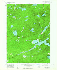
 1945 Caroga Lake1946 Print · USGSThe Southern Adirondacks and the Fulton County line appear here in the mid-1940s, showcasing a network of mountain hamlets and glacial lakes. Genealogists and local historians can trace early schoolhouse locations like Union School and remote landmarks such as St Josephs Cem.2 unique versions available
 - 1945 Map of Canada Lake, 1963 Print
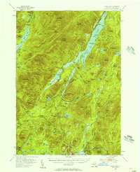
 1945 Canada Lake1963 Print · USGSThe Southern Adirondacks just after the war were a landscape of remote mountain camps and quiet lakefront settlements. Trace early developments around Canada Lake and Arietta, or locate old landmarks like Waters Millpond and the Aqueduct.4 unique versions available
 - 1945 Map of Lassellsville, 1964 Print
 1945 Lassellsville1964 Print · USGSFulton County and the southern Adirondack fringe are captured here just after the turn of the century, showing a landscape of small mill towns and isolated highland settlements. Researchers can trace family-named crossroads like Fical Corners and vanished industrial sites at Glasgow Mills or Newkirk Mills.
 - 1946 Map of Canada Lake
 1946 Canada Lake1946 Print · USGSThe southern Adirondack wilderness comes into focus in the mid-1940s at the border of Hamilton and Fulton Counties. Researchers can trace early settlements and natural landmarks like Stewart Landing, Waters Millpond, and the heights of Kane Mtn.2 unique versions available
 - 1950 Map of Utica, 1951 Print
 1950 Utica1951 Print · USGSCentral New York in the post-war era showcases the industrial Mohawk Valley and the pristine Adirondack interior. Researchers can trace transportation networks like the New York Central Railroad and find early Cold War sites such as Griffiss Air Force Base.
 - 1954 Map of Lake Pleasant, 1957 Print
 1954 Lake Pleasant1957 Print · USGSMid-century Hamilton County comes alive in this survey of the Lake Pleasant and Sacandaga Lake wilderness. Genealogists and researchers can trace the roads to Speculator, locate the Piseco Sch, or find remote landmarks like Whitehouse.6 unique versions available
 - 1954 Map of Blue Mountain, 1957 Print
 1954 Blue Mountain1957 Print · USGSIn the mid-1950s, this Adirondack landscape centers on the growing recreational hubs of Long Lake and Blue Mountain Lake. Genealogists and hikers can trace the Northville-Lake Placid Trail past the Long Lake Cem and the remote Forest House.6 unique versions available
 - 1954 Map of Piseco Lake, 1957 Print
 1954 Piseco Lake1957 Print · USGSMid-century Hamilton County is captured here in detail, showcasing the high-elevation settlements and lakes of the southern Adirondacks. Genealogists and historians can trace family locations and remote sites like Morehouseville, Shaker Place, and the Spruce Hill Cem.5 unique versions available
 - 1954 Map of Indian Lake, 1957 Print
 1954 Indian Lake1957 Print · USGSThe Adirondack wilderness of the mid-fifties is centered here around the long reach of INDIAN LAKE. Researchers can trace old mountain routes like Military Road or locate remote outposts such as Perkins Clearing, Sabael, and the Snowy Mountain Lookout Tower.6 unique versions available
 - 1954 Map of West Canada Lakes, 1957 Print
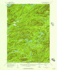 1954 West Canada Lakes1957 Print · USGSHamilton County's backcountry is captured here in the mid-1950s, showing a landscape of sporting camps and early hiking trails. Researchers can trace the path of the Northville Lake Placid Trail through Kenwells, Millers Camp, and the heights of Wakely Mountain.4 unique versions available
 - 1954 Map of Raquette Lake, 1957 Print
 1954 Raquette Lake1957 Print · USGSDeep in the Adirondack Park during the mid-fifties, this survey reveals the remote settlements and intricate waterways of the central New York wilderness. Genealogists and historians can trace local landmarks like St Williams Ch, the Raquette Lake Sch, and family-named features such as Antlers Point.5 unique versions available
Showing maps 1-25 of 145
Top cities near Arietta
- Indian Lake historical maps
- Ohio historical maps
- Lake Pleasant historical maps
- Long Lake historical maps
- Wells historical maps
- Speculator historical maps
See more
Top neighborhoods of Arietta
- Higgins Bay historical maps
- Piseco historical maps
- Averys Place historical maps
- Powley Place historical maps
- Rudeston historical maps
- Shaker Place historical maps
Frequently asked questions
- What are the different types of historical maps available for Arietta?
- What is the oldest map of Arietta?
- Where can I purchase historical maps of Arietta for my home or office?
- Where can I download high-res historical maps of Arietta?
- Are there historical topographic maps available for Arietta?
- Is there historical aerial imagery available for Arietta?
- Where are historical maps of Arietta sourced from?