1990s Maps of Benson, New York
Explore 5 historic maps of Benson from the 1990s. These maps offer a rare glimpse into what life looked like during the 1990s — showing old roads, neighborhoods, homes, and landmarks that have changed or disappeared over time.
Whether you're researching your family's past, planning a metal detecting trip, or studying how Benson's landscape evolved across the 1990s, these high-resolution maps are a powerful tool for exploring the history of this region.
- Focus on a specific era: All maps on this page are from the 1990s, giving you a focused view of this time period.
- See what’s changed: Compare century-old streets, trails, and buildings to today's modern landscape using overlays and satellite layers.
- Research with precision: Use these maps for genealogy, historical research, land use analysis, or educational projects.
- View, download, or print: Maps are fully viewable online in high resolution, and can be downloaded or printed for your own records.
Start exploring Benson's history through authentic maps from the 1990s. This is your window into the past.
Benson, NY maps
(5)- 1990 Map of Hope Falls
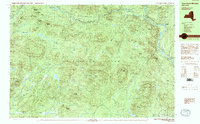
 1990 Hope Falls1990 Print · USGSThe Adirondack foothills of Saratoga and Hamilton Counties are shown here during the late twentieth century as the region balanced wilderness and remote settlement. Researchers can trace historic hamlets like Hope Falls and Tennantville or follow the shoreline of Great Sacandaga Lake past West Day.
 - 1990 Map of Three Ponds Mountain
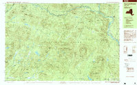
 1990 Three Ponds Mountain1990 Print · USGSThe Adirondack wilderness in the early nineties is a landscape of high peaks and scattered outposts in Hamilton County. Genealogists and hikers can trace the paths near Upper Benson, the riverside at Whitehouse, and the historic Hell Devil Dam (Site).2 unique versions available
 - 1997 Map of Three Ponds Mountain, 1999 Print
 1997 Three Ponds Mountain1999 Print · USGSHamilton County in the late 1990s is captured as a dense wilderness of the southern Adirondacks, structured by peaks and river valleys. Researchers can trace remote sites like Hell Devil Dam (Site) or the trails near Whitehouse and Silver Lake.
 - 1997 Map of Caroga Lake, 2000 Print
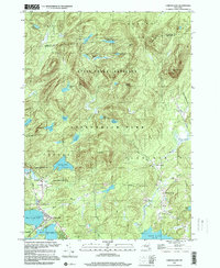 1997 Caroga Lake2000 Print · USGSCaroga Lake and the southern Adirondacks are captured here in the late 1990s as a landscape of mountain summits and glacial lakes. Researchers can trace local history through the Union Sch in Wheelerville and old family-named landmarks like St Josephs Cem and Holmes Lake Road.
 - 1999 Map of Hope Falls, 2000 Print
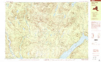 1999 Hope Falls2000 Print · USGSThe southeastern Adirondacks are shown in the late twentieth century as rugged forest preserves meet the shores of Great Sacandaga Lake. Genealogists and researchers can trace local landmarks like Hope Falls, Day Center, and family-named peaks such as Fraker Mountain and Thomas Hill.
End of results
Showing maps 1-5 of 5
Top cities near Benson
- Gloversville historical maps
- Johnstown historical maps
- Mayfield historical maps
- Broadalbin historical maps
- Northampton historical maps
- Providence historical maps
See more
Top neighborhoods of Benson
Frequently asked questions
- What are the different types of historical maps available for Benson?
- What is the oldest map of Benson?
- Where can I purchase historical maps of Benson for my home or office?
- Where can I download high-res historical maps of Benson?
- Are there historical topographic maps available for Benson?
- Is there historical aerial imagery available for Benson?
- Where are historical maps of Benson sourced from?