1990s Maps of Indian Lake, New York
Explore 10 historic maps of Indian Lake from the 1990s. These maps offer a rare glimpse into what life looked like during the 1990s — showing old roads, neighborhoods, homes, and landmarks that have changed or disappeared over time.
Whether you're researching your family's past, planning a metal detecting trip, or studying how Indian Lake's landscape evolved across the 1990s, these high-resolution maps are a powerful tool for exploring the history of this region.
- Focus on a specific era: All maps on this page are from the 1990s, giving you a focused view of this time period.
- See what’s changed: Compare century-old streets, trails, and buildings to today's modern landscape using overlays and satellite layers.
- Research with precision: Use these maps for genealogy, historical research, land use analysis, or educational projects.
- View, download, or print: Maps are fully viewable online in high resolution, and can be downloaded or printed for your own records.
Start exploring Indian Lake's history through authentic maps from the 1990s. This is your window into the past.
Indian Lake, NY maps
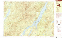
(10)- 1990 Map of Page Mountain
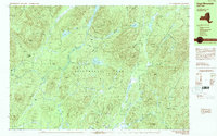 1990 Page Mountain1990 Print · USGSThe village of Speculator and the surrounding Adirondack wilderness appear here in the late twentieth century. Outdoor historians can trace old clearings like Indian Clearing and Perkins Clearing or find natural landmarks such as Austin Falls.
 - 1990 Map of Thirteenth Lake
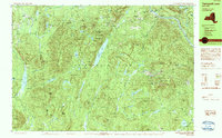 1990 Thirteenth Lake1990 Print · USGSThe Adirondack wilderness in the late twentieth century is preserved here through a dense network of peaks and high-country ponds. Genealogists and hikers can trace historic access routes like Old Farm Road or locate family-named landmarks including Edwards Hill and John Pond.2 unique versions available
 - 1990 Map of Indian Lake
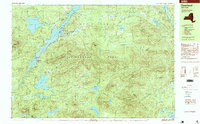
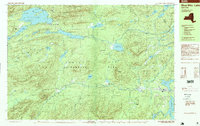
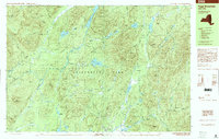
 1990 Indian Lake1990 Print · USGSHamilton County's interior wilderness is captured here in the 1990s, centering on the expansive waters of Indian Lake. Local historians and hikers can locate the Indian Lake Fire Tower, trace the shoreline of Lewey Lake, and identify campsites around Sabael.
 - 1997 Map of Deerland, 1999 Print
 1997 Deerland1999 Print · USGSThe northern Adirondacks come into focus in the late nineties, centering on the lakeside settlements and wilderness of Hamilton County. Researchers can trace the layout of Long Lake and Deerland, including local landmarks like the Post Office and Pine Island Park.
 - 1997 Map of Indian Lake, 1999 Print
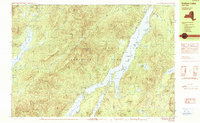
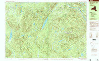
 1997 Indian Lake1999 Print · USGSThe Central Adirondacks are captured here in the late twentieth century, showing the established wilderness and lakefront life near Sabael. Outdoor enthusiasts and historians can trace the shoreline of Indian Lake to find John Mack Bay and the summits of Snowy Mountain.
 - 1997 Map of Blue Mtn Lake, 1999 Print
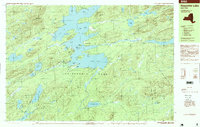
 1997 Blue Mtn Lake1999 Print · USGSThe Adirondack wilderness of the late nineties comes alive here, centered on the historic village of Blue Mountain Lake and the Adirondack Park. Local historians can trace early settlements and travel routes near Forest House, the local Cem, and along the shores of Lake Durant.
 - 1997 Map of Thirteenth Lake, 1999 Print
 1997 Thirteenth Lake1999 Print · USGSIn the Adirondack wilderness during the late nineties, this landscape shows the convergence of high peaks and river headwaters. You can trace the rugged topography between Gore Mountain and Thirteenth Lake, finding backcountry landmarks like the Shelter at John Pond and the remote settlement of Sodom.2 unique versions available
 - 1997 Map of Raquette Lake, 1999 Print
 1997 Raquette Lake1999 Print · USGSThe central Adirondacks are mapped here in the late nineties, featuring the sprawling irregular coastline of Raquette Lake. Researchers can trace old routes along Browns Tract and locate historic points like Sagamore and Antlers Point.
 - 1997 Map of Dutton Mountain, 2000 Print
 1997 Dutton Mountain2000 Print · USGSAdirondack wilderness and private sporting clubs are documented during the late 1990s as the Hudson River winds through Essex County. Researchers can trace historic retreats and camps including Saints Rest, the Gooley Club, and Northern Frontier Camp.
 - 1997 Map of Page Mountain, 2000 Print
 1997 Page Mountain2000 Print · USGSThe wilderness of Hamilton County is documented here in the late nineties, centered on the Speculator corporate boundary and the surrounding forest clearings. Researchers can locate remote sites like Indian Clearing, the waters of Christine Falls, and the natural landmark at Kunjamuk Cave.
End of results
Showing maps 1-10 of 10
Top cities near Indian Lake
- Johnsburg historical maps
- Thurman historical maps
- Lake Pleasant historical maps
- Long Lake historical maps
- Minerva historical maps
- Wells historical maps
See more
Top neighborhoods of Indian Lake
Frequently asked questions
- What are the different types of historical maps available for Indian Lake?
- What is the oldest map of Indian Lake?
- Where can I purchase historical maps of Indian Lake for my home or office?
- Where can I download high-res historical maps of Indian Lake?
- Are there historical topographic maps available for Indian Lake?
- Is there historical aerial imagery available for Indian Lake?
- Where are historical maps of Indian Lake sourced from?