1940s Maps of Farrel Corner, Newport
Explore 2 historic maps of Farrel Corner from the 1940s. These maps offer a rare glimpse into what life looked like during the 1940s — showing old roads, neighborhoods, homes, and landmarks that have changed or disappeared over time.
Whether you're researching your family's past, planning a metal detecting trip, or studying how Farrel Corner's landscape evolved across the 1940s, these high-resolution maps are a powerful tool for exploring the history of this region.
- Focus on a specific era: All maps on this page are from the 1940s, giving you a focused view of this time period.
- See what’s changed: Compare century-old streets, trails, and buildings to today's modern landscape using overlays and satellite layers.
- Research with precision: Use these maps for genealogy, historical research, land use analysis, or educational projects.
- View, download, or print: Maps are fully viewable online in high resolution, and can be downloaded or printed for your own records.
Start exploring Farrel Corner's history through authentic maps from the 1940s. This is your window into the past.
Farrel Corner, Newport maps
(2)- 1943 Map of Newport, 1953 Print
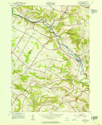 1943 Newport1953 Print · USGSThe West Canada Valley comes alive in this wartime survey, showing the interconnected rail-and-river economies of Herkimer and Oneida Counties. Genealogists can trace the location of the Irish Settlement, family cemeteries like Bromley Cemetery, and several district schools.3 unique versions available
 - 1945 Map of Newport
 1945 Newport1945 Print · USGSHerkimer County's West Canada Creek valley is shown at its mid-century peak of rural development, tracing the path of the New York Central railroad through Poland and Newport. Genealogists can locate family landmarks like the Irish Settlement, Bromley Cem, and many local schools.
End of results
Showing maps 1-2 of 2
Top cities near Farrel Corner
- Utica historical maps
- New Hartford historical maps
- Whitestown historical maps
- German Flatts historical maps
- Herkimer historical maps
- Marcy historical maps
See more
Frequently asked questions
- What are the different types of historical maps available for Farrel Corner?
- What is the oldest map of Farrel Corner?
- Where can I purchase historical maps of Farrel Corner for my home or office?
- Where can I download high-res historical maps of Farrel Corner?
- Are there historical topographic maps available for Farrel Corner?
- Is there historical aerial imagery available for Farrel Corner?
- Where are historical maps of Farrel Corner sourced from?