1940s Maps of Northwood, Russia
Explore 2 historic maps of Northwood from the 1940s. These maps offer a rare glimpse into what life looked like during the 1940s — showing old roads, neighborhoods, homes, and landmarks that have changed or disappeared over time.
Whether you're researching your family's past, planning a metal detecting trip, or studying how Northwood's landscape evolved across the 1940s, these high-resolution maps are a powerful tool for exploring the history of this region.
- Focus on a specific era: All maps on this page are from the 1940s, giving you a focused view of this time period.
- See what’s changed: Compare century-old streets, trails, and buildings to today's modern landscape using overlays and satellite layers.
- Research with precision: Use these maps for genealogy, historical research, land use analysis, or educational projects.
- View, download, or print: Maps are fully viewable online in high resolution, and can be downloaded or printed for your own records.
Start exploring Northwood's history through authentic maps from the 1940s. This is your window into the past.
Northwood, Russia maps
(2)- 1946 Map of Hinckley
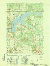 1946 Hinckley1946 Print · USGSUpper Herkimer County in the mid-1940s is defined by the winding waters of the Hinckley Reservoir and the rural crossroads of the Adirondack foothills. Researchers can locate vanished rural landmarks like School No. 4 and the Century Cem, or trace the old roads through Partyville Corners and Grant.4 unique versions available
 - 1947 Map of Hinckley
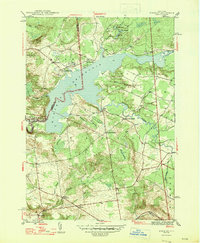 1947 Hinckley1947 Print · USGSThe foothills of the southwest Adirondacks come alive in the mid-forties, centered on the sprawling waters of Hinckley Reservoir. Researchers can trace rural life through vanished schoolhouses like School No 4 and local burials at Century Cem and Gravesville Cem.2 unique versions available
End of results
Showing maps 1-2 of 2
Top cities near Northwood
- Utica historical maps
- Whitestown historical maps
- Herkimer historical maps
- Marcy historical maps
- Boonville historical maps
- Trenton historical maps
See more
Frequently asked questions
- What are the different types of historical maps available for Northwood?
- What is the oldest map of Northwood?
- Where can I purchase historical maps of Northwood for my home or office?
- Where can I download high-res historical maps of Northwood?
- Are there historical topographic maps available for Northwood?
- Is there historical aerial imagery available for Northwood?
- Where are historical maps of Northwood sourced from?