1980s Maps of Schuyler, New York
Explore 5 historic maps of Schuyler from the 1980s. These maps offer a rare glimpse into what life looked like during the 1980s — showing old roads, neighborhoods, homes, and landmarks that have changed or disappeared over time.
Whether you're researching your family's past, planning a metal detecting trip, or studying how Schuyler's landscape evolved across the 1980s, these high-resolution maps are a powerful tool for exploring the history of this region.
- Focus on a specific era: All maps on this page are from the 1980s, giving you a focused view of this time period.
- See what’s changed: Compare century-old streets, trails, and buildings to today's modern landscape using overlays and satellite layers.
- Research with precision: Use these maps for genealogy, historical research, land use analysis, or educational projects.
- View, download, or print: Maps are fully viewable online in high resolution, and can be downloaded or printed for your own records.
Start exploring Schuyler's history through authentic maps from the 1980s. This is your window into the past.
Schuyler, NY maps
(5)- 1982 Map of Newport, 1983 Print
 1982 Newport1983 Print · USGSThe West Canada Creek valley in the early eighties shows a landscape of upland ridges and riverside villages. Researchers can trace historic family locations at Irish Settlement, Tanner Hill Cem, and the specialized USAF Newport Test Annex.
 - 1982 Map of Ilion, 1983 Print
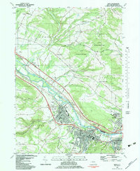 1982 Ilion1983 Print · USGSThe Mohawk Valley corridor thrives in the early eighties as a hub of industry and transit. Genealogists can trace family names at Armory Hill Cemetery and Oak View Cem, or locate landmarks like East Schuyler Ch and the Erie Canal.
 - 1983 Map of Utica East
 1983 Utica East1983 Print · USGSThe Mohawk Valley corridor shows its industrial and transit strength in the 1980s, centered on the vital waters of the Erie Canal. Genealogists can trace family names at Forest Hill Cemetery and Budlong Cem or locate the historic Masonic Home.
 - 1983 Map of South Trenton
 1983 South Trenton1983 Print · USGSThe rural highlands of Oneida County meet the growing suburbs of Utica in the early eighties. Researchers can trace family history through South Trenton and Holland Patent, or locate lost landmarks like the Drive-in Theater and Horatio Mall.
 - 1985 Map of Utica, 1986 Print
 1985 Utica1986 Print · USGSThe Mohawk Valley in the mid-eighties shows a landscape of industrial river cities and high-tech military hubs before the post-Cold War transition. Trace the development of Rome and Utica, the operations at Griffiss Air Force Base, and the lakeside activity at Oneida Lake.2 unique versions available
End of results
Showing maps 1-5 of 5
Top cities near Schuyler
- Utica historical maps
- New Hartford historical maps
- Whitestown historical maps
- German Flatts historical maps
- Kirkland historical maps
- Herkimer historical maps
See more
Top neighborhoods of Schuyler
- Johnson Corners historical maps
- Baker Corners historical maps
- West Schuyler historical maps
- East Schuyler historical maps
- North Frankfort historical maps
Frequently asked questions
- What are the different types of historical maps available for Schuyler?
- What is the oldest map of Schuyler?
- Where can I purchase historical maps of Schuyler for my home or office?
- Where can I download high-res historical maps of Schuyler?
- Are there historical topographic maps available for Schuyler?
- Is there historical aerial imagery available for Schuyler?
- Where are historical maps of Schuyler sourced from?