1910s Maps of Webb, New York
Explore 6 historic maps of Webb from the 1910s. These maps offer a rare glimpse into what life looked like during the 1910s — showing old roads, neighborhoods, homes, and landmarks that have changed or disappeared over time.
Whether you're researching your family's past, planning a metal detecting trip, or studying how Webb's landscape evolved across the 1910s, these high-resolution maps are a powerful tool for exploring the history of this region.
- Focus on a specific era: All maps on this page are from the 1910s, giving you a focused view of this time period.
- See what’s changed: Compare century-old streets, trails, and buildings to today's modern landscape using overlays and satellite layers.
- Research with precision: Use these maps for genealogy, historical research, land use analysis, or educational projects.
- View, download, or print: Maps are fully viewable online in high resolution, and can be downloaded or printed for your own records.
Start exploring Webb's history through authentic maps from the 1910s. This is your window into the past.
Webb, NY maps
(6)- 1912 Map of Number Four
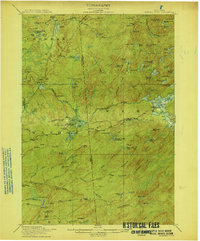
 1912 Number Four1912 Print · USGSThe Adirondack wilderness of Herkimer and Lewis counties is captured here in the early twentieth century before modern development. Trace the remote waterways from the Oswegatchie River down to Soft Maple Dam or locate family landmarks near Balsam Flats and Stillwater Mtn.
 - 1912 Map of Mc Keever
 1912 Mc Keever1912 Print · USGSThe southwestern Adirondack wilderness comes into focus in this early twentieth-century survey, showcasing the arrival of the railroad in a landscape of logging camps. Genealogists and researchers can trace the development of Mc Keever and locate family-named sites like Millard's Camp, Porters Corners, and Becks Camp.8 unique versions available
 - 1915 Map of Number Four
 1915 Number Four1915 Print · USGSThe wilderness of the North Country comes into focus in this pre-war survey of the Lewis and Herkimer county line. Researchers can trace the remote settlement of Number Four and locate early landmarks like Silver Mine Dam and Stillwater Mtn.5 unique versions available
 - 1916 Map of Oswegatchie
 1916 Oswegatchie1916 Print · USGSSt. Lawrence County industry and wilderness meet in the early twentieth century along the Oswegatchie River. Genealogists and historians can trace rail-tied settlements at Benson Mines, remote schools like White School, and numerous named lumber and sporting camps.3 unique versions available
 - 1918 Map of Oswegatchie
 1918 Oswegatchie1918 Print · USGSThe Adirondack wilderness in the 1910s reveals a hardworking landscape of iron mines and timber camps. Genealogists and historians can trace family roots at Benson Mines, locate remote schoolhouses like White School, and follow the path of the Lumber R. R.5 unique versions available
 - 1919 Map of Cranberry Lake, 1959 Print
 1919 Cranberry Lake1959 Print · USGSThe northern Adirondack wilderness is captured here just after the Great War, showing a landscape defined by timber, mining, and the winding Oswegatchie River. Trace the early development of Benson Mines, the State Ranger School, and the remote landing at Wanakena.3 unique versions available
End of results
Showing maps 1-6 of 6
Top cities near Webb
- Croghan historical maps
- Watson historical maps
- Diana historical maps
- Forestport historical maps
- Greig historical maps
- Lyonsdale historical maps
See more
Top neighborhoods of Webb
- Moshier Falls historical maps
- Brandreth historical maps
- Woods Lake historical maps
- Minnehaha historical maps
- Keepawa historical maps
- Big Moose historical maps
See more
Frequently asked questions
- What are the different types of historical maps available for Webb?
- What is the oldest map of Webb?
- Where can I purchase historical maps of Webb for my home or office?
- Where can I download high-res historical maps of Webb?
- Are there historical topographic maps available for Webb?
- Is there historical aerial imagery available for Webb?
- Where are historical maps of Webb sourced from?