Old Maps of Little Rapids, Webb
Explore 14 old maps of Little Rapids, spanning from 1903 to today. These high-resolution historic maps reveal how streets, neighborhoods, landmarks, and natural features evolved over time — perfect for genealogy, metal detecting, research, and local history exploration.
What you can do with these maps:
- See how Little Rapids changed over time: Compare historical maps to modern-day views to trace roads, homesites, rail lines & more.
- View detailed metadata: Each map includes creators, publishers, year, scale, and archive source.
- Overlay maps with satellite & LiDAR: Visualize the past alongside modern tools to explore terrain & human change.
- Trusted historical sources: Maps sourced from the USGS, Library of Congress, and other archives.
- Access maps your way: View online, download high-res files, or order prints for personal or research use.
Start exploring old maps of Little Rapids to uncover forgotten places, hidden landmarks, and the deep history beneath your feet.
Little Rapids, Webb maps
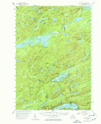
(14)- 1903 Map of Big Moose
 1903 Big Moose1903 Print · USGSThe Adirondack wilderness of the early twentieth century was a landscape of remote rail outposts and hidden glacial lakes. Trace the Adirondack Division line through the mountains to find family camps near Big Moose, Eagle Bay, and the Steamboat Route.11 unique versions available
 - 1950 Map of Utica, 1951 Print
 1950 Utica1951 Print · USGSCentral New York in the post-war era showcases the industrial Mohawk Valley and the pristine Adirondack interior. Researchers can trace transportation networks like the New York Central Railroad and find early Cold War sites such as Griffiss Air Force Base.
 - 1954 Map of Big Moose, 1958 Print
 1954 Big Moose1958 Print · USGSThe Adirondack wilderness in the mid-fifties remains a world of remote rail stations and sprawling lake systems. Researchers can trace the New York Central Railroad corridor through isolated outposts like Beaver River, Brandreth, and Keepawa.6 unique versions available
 - 1957 Map of Utica
 1957 Utica1957 Print · USGSCentral New York and the Adirondack foothills are captured here in the mid-fifties, showing a landscape defined by the Mohawk River corridor and the growing highway system. Genealogists and researchers can trace the rail lines of the New York Central and locate communities from Lowville to Gloversville.
 - 1962 Map of Utica
 1962 Utica1962 Print · USGSCentral New York and the Adirondack wilderness are captured here during the mid-century era of highway and industrial expansion. Genealogists and historians can trace the development of the New York State Thruway and local rail lines connecting Utica, Rome, and Gloversville.3 unique versions available
 - 1964 Map of Utica
 1964 Utica1964 Print · USGSCentral New York and the high wilderness of the Adirondacks are captured here during the post-war era of infrastructure expansion. Researchers can trace the development of the New York State Thruway alongside historic corridors like the Oneida Lake (Barge Canal Route) and the N. Y. Central railroad.
 - 1967 Map of Utica
 1967 Utica1967 Print · USGSCentral New York's industrial Mohawk Valley meets the Adirondack wilderness in the 1960s, showing the region's transition from manufacturing hubs to state-managed parklands. Trace historic settlements and sites like Griffiss Air Force Base, Colgate University, and the Lyons Falls Paper Mill.
 - 1985 Map of Raquette Lake, 1986 Print
 1985 Raquette Lake1986 Print · USGSThe central Adirondacks are documented here in the mid-1980s, showcasing the complex lake systems and early rail routes that defined the region. Researchers can trace historic landmarks like Sagamore, isolated stops along the Adirondack RR, and the remote layout of Old Forge.2 unique versions available
 - 1989 Map of Beavers River
 1989 Beavers River1989 Print · USGSIn the central Adirondacks during the late eighties, this area shows a landscape defined by isolation and outdoor heritage. Trace the path of the Old Railroad Grade past remote settlements like Beaver River, Norridgewock, and Keepawa.2 unique versions available
 - 2010 Map of Nehasane Lake, 2010 Print
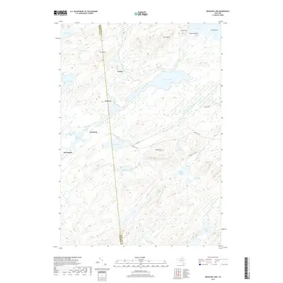
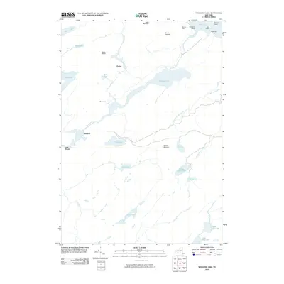 2010 Nehasane Lake2010 Print · USGSCovers Little Rapids, including Webb, Long Lake, and other nearby areas
 - 2013 Map of Nehasane Lake, 2013 Print
 2013 Nehasane Lake2013 Print · USGSCovers Little Rapids, including Webb, Long Lake, and other nearby areas
 - 2016 Map of Nehasane Lake, 2016 Print
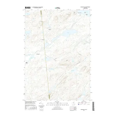 2016 Nehasane Lake2016 Print · USGSCovers Little Rapids, including Webb, Long Lake, and other nearby areas
 - 2019 Map of Nehasane Lake, 2019 Print
 2019 Nehasane Lake2019 Print · USGSCovers Little Rapids, including Webb, Long Lake, and other nearby areas
 - 2023 Map of Nehasane Lake, 2023 Print
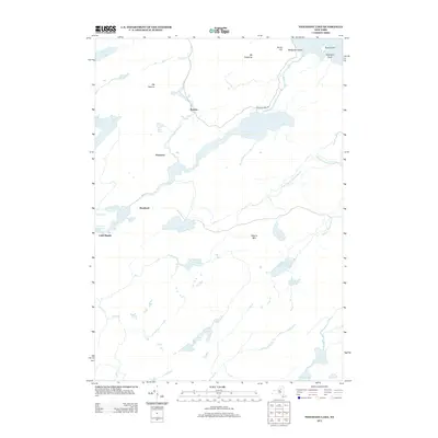
 2023 Nehasane Lake2023 Print · USGSThe Adirondack wilderness of Hamilton County is captured here in the 2020s, showing a land of private estates and glacial lakes. Trace the quiet settlements of Brandreth and Keepawa along the Beaver River or locate landmarks like Mount Electra and Nehasane Lake.
End of results
Showing maps 1-14 of 14
Top cities near Little Rapids
- Webb historical maps
- Colton historical maps
- Fine historical maps
- Ohio historical maps
- Long Lake historical maps
- Old Forge historical maps
See more
Frequently asked questions
- What are the different types of historical maps available for Little Rapids?
- What is the oldest map of Little Rapids?
- Where can I purchase historical maps of Little Rapids for my home or office?
- Where can I download high-res historical maps of Little Rapids?
- Are there historical topographic maps available for Little Rapids?
- Is there historical aerial imagery available for Little Rapids?
- Where are historical maps of Little Rapids sourced from?