Old Maps of Webb, New York for Metal Detecting
Plan your next treasure hunt with 131 historic maps of Webb. Find old homesites, ghost towns, trails, and gathering spots that may be lost to time — perfect for identifying promising metal detecting locations.
- Locate forgotten sites: Uncover places like long-lost settlements, abandoned rail lines, or gathering spots.
- Plan better hunts: Use map overlays combined with LiDAR or satellite views to narrow in on historically rich areas.
- Made for detectorists: Thousands of hobbyists use these maps to discover relics, coins, and hidden history.
Use these historic maps to boost your research and find new opportunities beneath the surface of Webb.
Webb, NY maps
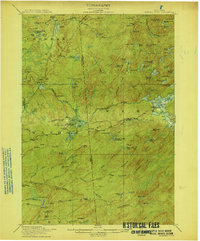
(131)- 1901 Map of Old Forge
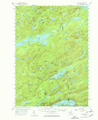
 1901 Old Forge1901 Print · USGSIn the Adirondack wilderness at the turn of the century, this area shows a unique network of early camps and water routes. Researchers can trace the Steamboat Route through the Chain Lakes or locate historic outposts like Bishy Lodge and Atwell.10 unique versions available
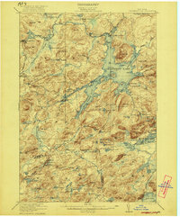
 - 1903 Map of Big Moose
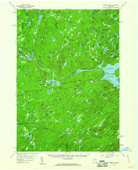
 1903 Big Moose1903 Print · USGSThe Adirondack wilderness of the early twentieth century was a landscape of remote rail outposts and hidden glacial lakes. Trace the Adirondack Division line through the mountains to find family camps near Big Moose, Eagle Bay, and the Steamboat Route.11 unique versions available
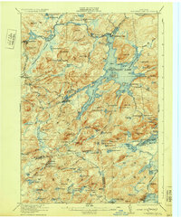
 - 1912 Map of Number Four
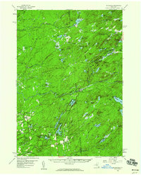
 1912 Number Four1912 Print · USGSThe Adirondack wilderness of Herkimer and Lewis counties is captured here in the early twentieth century before modern development. Trace the remote waterways from the Oswegatchie River down to Soft Maple Dam or locate family landmarks near Balsam Flats and Stillwater Mtn.
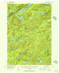
 - 1912 Map of Mc Keever
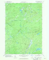
 1912 Mc Keever1912 Print · USGSThe southwestern Adirondack wilderness comes into focus in this early twentieth-century survey, showcasing the arrival of the railroad in a landscape of logging camps. Genealogists and researchers can trace the development of Mc Keever and locate family-named sites like Millard's Camp, Porters Corners, and Becks Camp.8 unique versions available
 - 1915 Map of Number Four
 1915 Number Four1915 Print · USGSThe wilderness of the North Country comes into focus in this pre-war survey of the Lewis and Herkimer county line. Researchers can trace the remote settlement of Number Four and locate early landmarks like Silver Mine Dam and Stillwater Mtn.5 unique versions available
 - 1916 Map of Oswegatchie
 1916 Oswegatchie1916 Print · USGSSt. Lawrence County industry and wilderness meet in the early twentieth century along the Oswegatchie River. Genealogists and historians can trace rail-tied settlements at Benson Mines, remote schools like White School, and numerous named lumber and sporting camps.3 unique versions available
 - 1918 Map of Oswegatchie
 1918 Oswegatchie1918 Print · USGSThe Adirondack wilderness in the 1910s reveals a hardworking landscape of iron mines and timber camps. Genealogists and historians can trace family roots at Benson Mines, locate remote schoolhouses like White School, and follow the path of the Lumber R. R.5 unique versions available
 - 1919 Map of Cranberry Lake, 1959 Print
 1919 Cranberry Lake1959 Print · USGSThe northern Adirondack wilderness is captured here just after the Great War, showing a landscape defined by timber, mining, and the winding Oswegatchie River. Trace the early development of Benson Mines, the State Ranger School, and the remote landing at Wanakena.3 unique versions available
 - 1921 Map of Cranberry Lake
 1921 Cranberry Lake1921 Print · USGSIn the early 1920s, this area of the Adirondacks was a nexus of wilderness and industry, from the waters of Cranberry Lake to the iron operations at Benson Mines. Researchers can trace the early grounds of the State Ranger School and follow the New York Central RR through Wanakena.7 unique versions available
 - 1931 Map of Cranberry Lake
 1931 Cranberry Lake1931 Print · USGSThe Adirondack wilderness around Cranberry Lake is captured here in the early thirties, showcasing a landscape of logging, mining, and remote rail travel. Genealogists and historians can trace the industrial footprints of Benson Mines, the State Ranger School, and the New York Central line.
 - 1948 Map of Ogdensburg, 1973 Print
 1948 Ogdensburg1973 Print · USGSThe international border along the St Lawrence River comes to life in the late 1940s, showing the vital rail and water connections between New York and Ontario. Researchers can trace the grounds of St Lawrence University, the massive Camp Drum military reservation, and the historic Rideau River and Canal.2 unique versions available
 - 1950 Map of Utica, 1951 Print
 1950 Utica1951 Print · USGSCentral New York in the post-war era showcases the industrial Mohawk Valley and the pristine Adirondack interior. Researchers can trace transportation networks like the New York Central Railroad and find early Cold War sites such as Griffiss Air Force Base.
 - 1951 Map of Ogdensburg
 1951 Ogdensburg1951 Print · USGSThe St. Lawrence frontier and the North Country are captured here during the post-war era, from the river ports to the high Adirondacks. Genealogists and historians can trace the rail-and-river economy through Ogdensburg, the Rutland rail lines, and Potsdam.
 - 1953 Map of Ogdensburg
 1953 Ogdensburg1953 Print · USGSThe North Country and St. Lawrence Valley are shown here in the early fifties, just as the region’s rail-and-river economy remained in full swing. Genealogists and historians can trace family-named corners and rural hubs along the Rutland railroad or locate heritage sites near Ogdensburg, Potsdam, and the St Regis Indian Reservation.
 - 1954 Map of Old Forge, 1956 Print
 1954 Old Forge1956 Print · USGSThe Adirondack wilderness around Old Forge is shown in the mid-1950s, detailing a landscape of mountain lodges and interior lakes. Genealogists and historians can trace remote outposts like Bisby Lodge, Atwell, and the Riverside Cem along the Fulton Chain Lakes.4 unique versions available
 - 1954 Map of Big Moose, 1958 Print
 1954 Big Moose1958 Print · USGSThe Adirondack wilderness in the mid-fifties remains a world of remote rail stations and sprawling lake systems. Researchers can trace the New York Central Railroad corridor through isolated outposts like Beaver River, Brandreth, and Keepawa.6 unique versions available
 - 1957 Map of Utica
 1957 Utica1957 Print · USGSCentral New York and the Adirondack foothills are captured here in the mid-fifties, showing a landscape defined by the Mohawk River corridor and the growing highway system. Genealogists and researchers can trace the rail lines of the New York Central and locate communities from Lowville to Gloversville.
 - 1957 Map of Number Four, 1964 Print
 1957 Number Four1964 Print · USGSThe western Adirondacks during the mid-1950s reveal a landscape of managed wilderness and remote settlements. Researchers can trace historic access routes like Prentice Road or locate the Lookout Tower near Number Four and Stillwater.4 unique versions available
 - 1958 Map of Mc Keever, 1960 Print
 1958 Mc Keever1960 Print · USGSThe Herkimer and Oneida county lines meet in the heart of the Adirondacks during the late fifties, where rail lines and river branches shaped the local economy. Genealogists can locate family-named sites like Hubbards and Porters Corners or trace the New York Central through Minnehaha.4 unique versions available
 - 1961 Map of Ogdensburg
 1961 Ogdensburg1961 Print · USGSThe St. Lawrence valley and the Adirondack high country meet in this early sixties survey during a peak era for rail and river commerce. Genealogists and historians can trace the paths of the New York Central railroad through remote settlements like Wanakena, Conifer, and Piercefield.
 - 1962 Map of Utica
 1962 Utica1962 Print · USGSCentral New York and the Adirondack wilderness are captured here during the mid-century era of highway and industrial expansion. Genealogists and historians can trace the development of the New York State Thruway and local rail lines connecting Utica, Rome, and Gloversville.3 unique versions available
 - 1964 Map of Utica
 1964 Utica1964 Print · USGSCentral New York and the high wilderness of the Adirondacks are captured here during the post-war era of infrastructure expansion. Researchers can trace the development of the New York State Thruway alongside historic corridors like the Oneida Lake (Barge Canal Route) and the N. Y. Central railroad.
 - 1966 Map of Oswegatchie SE, 1971 Print
 1966 Oswegatchie SE1971 Print · USGSSt. Lawrence and Herkimer Counties are captured in the mid-sixties, showing a wild landscape of the Adirondack interior. Researchers and outdoorsmen can trace the paths of the Post Trail or locate remote water bodies like Emerald Lake and Streeter Lake.2 unique versions available
 - 1966 Map of Oswegatchie SW, 1971 Print
 1966 Oswegatchie SW1971 Print · USGSAdirondack wilderness near the junction of three counties was still largely roadless in the mid-sixties. Outdoor historians and researchers can trace remote water routes and landmarks like Bryants Bridge, Trout Lake, and the Lookout Tower on Bald Mtn.
 - 1967 Map of Utica
 1967 Utica1967 Print · USGSCentral New York's industrial Mohawk Valley meets the Adirondack wilderness in the 1960s, showing the region's transition from manufacturing hubs to state-managed parklands. Trace historic settlements and sites like Griffiss Air Force Base, Colgate University, and the Lyons Falls Paper Mill.
Showing maps 1-25 of 131
Top cities near Webb
- Croghan historical maps
- Watson historical maps
- Diana historical maps
- Forestport historical maps
- Greig historical maps
- Lyonsdale historical maps
See more
Top neighborhoods of Webb
- Moshier Falls historical maps
- Brandreth historical maps
- Woods Lake historical maps
- Minnehaha historical maps
- Keepawa historical maps
- Big Moose historical maps
See more
Frequently asked questions
- What are the different types of historical maps available for Webb?
- What is the oldest map of Webb?
- Where can I purchase historical maps of Webb for my home or office?
- Where can I download high-res historical maps of Webb?
- Are there historical topographic maps available for Webb?
- Is there historical aerial imagery available for Webb?
- Where are historical maps of Webb sourced from?