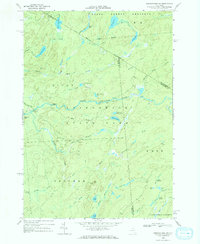
1966 Map of Oswegatchie SW
USGS Topo · Published 1971About this map
Adirondack State Park dominates this landscape, where the Middle Branch Oswegatchie River winds through a dense network of marshes and water bodies. The geography is defined by its transition from high peaks like Panther Mtn and Bald Mtn to low-lying wetlands such as Cedar Swamp and Blue Swamp. This 1966 photogrammetric survey reveals a region primarily dedicated to the State Forest Preserve, with very few permanent structures aside from a Lookout Tower and Bryants Bridge crossing the river. Remote ponds and flows, including Mullins Flow, Silver Dawn Lake, and the curiously named Mouldy Pond, indicate a territory shaped by natural drainage and seasonal water levels rather than industrial or residential development. The map also delineates the meeting point of St Lawrence, Lewis, and Herkimer counties within this wooded expanse.
Find a feature on this map
50 named features on this map. Tap any name to fly to it.
Don’t see what you’re looking for? This feature index may not catch every label — zoom into the map to look around manually.
Map Details
Editions of this 1966 Oswegatchie SW Map
This is the sole edition of this map. No revisions or reprints were ever made.
Other maps of this area

1911 · Lowville
USGS Topo · 1:62,500

1912 · Number Four
USGS Topo · 1:62,500

1913 · Lowville
USGS Topo · 1:62,500

1913 · Lake Bonaparte
USGS Topo · 1:62,500

1915 · Number Four
USGS Topo · 1:62,500

1916 · Lake Bonaparte
USGS Topo · 1:62,500

1916 · Oswegatchie
USGS Topo · 1:62,500

1918 · Oswegatchie
USGS Topo · 1:62,500

1948 · Ogdensburg
USGS Topo · 1:250,000

1950 · Utica
USGS Topo · 1:250,000