1950s Maps of Adams Center, Adams
Explore 6 historic maps of Adams Center from the 1950s. These maps offer a rare glimpse into what life looked like during the 1950s — showing old roads, neighborhoods, homes, and landmarks that have changed or disappeared over time.
Whether you're researching your family's past, planning a metal detecting trip, or studying how Adams Center's landscape evolved across the 1950s, these high-resolution maps are a powerful tool for exploring the history of this region.
- Focus on a specific era: All maps on this page are from the 1950s, giving you a focused view of this time period.
- See what’s changed: Compare century-old streets, trails, and buildings to today's modern landscape using overlays and satellite layers.
- Research with precision: Use these maps for genealogy, historical research, land use analysis, or educational projects.
- View, download, or print: Maps are fully viewable online in high resolution, and can be downloaded or printed for your own records.
Start exploring Adams Center's history through authentic maps from the 1950s. This is your window into the past.
Adams Center, Adams maps
(6)- 1950 Map of Utica, 1951 Print
 1950 Utica1951 Print · USGSCentral New York in the post-war era showcases the industrial Mohawk Valley and the pristine Adirondack interior. Researchers can trace transportation networks like the New York Central Railroad and find early Cold War sites such as Griffiss Air Force Base.
 - 1957 Map of Utica
 1957 Utica1957 Print · USGSCentral New York and the Adirondack foothills are captured here in the mid-fifties, showing a landscape defined by the Mohawk River corridor and the growing highway system. Genealogists and researchers can trace the rail lines of the New York Central and locate communities from Lowville to Gloversville.
 - 1959 Map of Rodman, 1961 Print
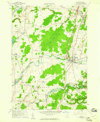
 1959 Rodman1961 Print · USGSJefferson County's rural uplands are shown in the late fifties, a time when small hamlets still centered around the deep ravines of the Tug Hill region. Trace family roots and local geography through settlements like Rodman, the Honeyville Cem, and crossroads at Whitford Corners.3 unique versions available
 - 1959 Map of Adams, 1961 Print
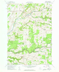
 1959 Adams1961 Print · USGSJefferson County was transitioning into the modern highway era in the late fifties as the EMPIRE STATEWAY began to cut through traditional farm country. Genealogists can trace family roots through numerous locations like Wardwell Settlement, St Cecelias Ch, and Giddingsville Cem.3 unique versions available
 - 1959 Map of Watertown, 1961 Print
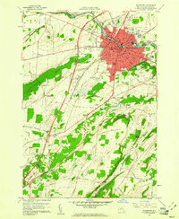 1959 Watertown1961 Print · USGSWatertown and its surrounding townships thrive along the Black River in the late fifties, showcasing a period of robust civic infrastructure and rural expansion. Genealogists can trace family names through the Fields Settlement Cem, locate the Cupertino Friary, or find old homesteads near Talcott Falls.3 unique versions available
 - 1959 Map of Sackets Harbor, 1961 Print
 1959 Sackets Harbor1961 Print · USGSThe Jefferson County lakeshore in the late fifties is captured here as a mix of military tradition and rural crossroads. Trace the legacy of Sackets Harbor via its Military Cem or explore long-established intersections like Baggs Corner and Sulphur Springs.2 unique versions available
End of results
Showing maps 1-6 of 6
Top cities near Adams Center
- Le Ray historical maps
- Watertown historical maps
- Watertown historical maps
- Brownville historical maps
- Adams historical maps
- Sandy Creek historical maps
See more
Frequently asked questions
- What are the different types of historical maps available for Adams Center?
- What is the oldest map of Adams Center?
- Where can I purchase historical maps of Adams Center for my home or office?
- Where can I download high-res historical maps of Adams Center?
- Are there historical topographic maps available for Adams Center?
- Is there historical aerial imagery available for Adams Center?
- Where are historical maps of Adams Center sourced from?