1940s Maps of Cazenovia, New York
Explore 11 historic maps of Cazenovia from the 1940s. These maps offer a rare glimpse into what life looked like during the 1940s — showing old roads, neighborhoods, homes, and landmarks that have changed or disappeared over time.
Whether you're researching your family's past, planning a metal detecting trip, or studying how Cazenovia's landscape evolved across the 1940s, these high-resolution maps are a powerful tool for exploring the history of this region.
- Focus on a specific era: All maps on this page are from the 1940s, giving you a focused view of this time period.
- See what’s changed: Compare century-old streets, trails, and buildings to today's modern landscape using overlays and satellite layers.
- Research with precision: Use these maps for genealogy, historical research, land use analysis, or educational projects.
- View, download, or print: Maps are fully viewable online in high resolution, and can be downloaded or printed for your own records.
Start exploring Cazenovia's history through authentic maps from the 1940s. This is your window into the past.
Cazenovia, NY maps
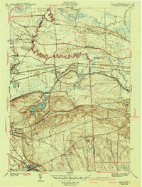
(11)- 1942 Map of Oran, 1957 Print
 1942 Oran1957 Print · USGSUpper Onondaga County during the early 1940s is mapped here with a focus on its steep ravines and rural school districts. Genealogists and hikers can trace old property boundaries near Delphi Falls, locate the Indian Hill Memorial, or find family plots like Sharp Cem.
 - 1943 Map of Manlius
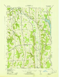
 1943 Manlius1943 Print · USGSOnondaga County in the early 1940s reveals a landscape where historic waterways meet modern rail and air infrastructure. Researchers can trace the paths of the Old Erie Canal, locate the Manlius Academy, and explore rural sites like Fyler Settlement.2 unique versions available
 - 1943 Map of Oran
 1943 Oran1943 Print · USGSOnondaga County's rural landscape is captured during the war years, showing a network of small schoolhouses and family cemeteries across the uplands. Genealogists and local historians can trace legacy landmarks like Indian Hill Memorial, Southwell Cem, and the old Manlius Sch.2 unique versions available
 - 1943 Map of De Ruyter, 1958 Print
 1943 De Ruyter1958 Print · USGSUpper New York State’s high country at the start of the 1940s shows a landscape of ridge-top farms and valley rail lines. Trace the Lehigh Valley Railroad corridor past De Ruyter Reservoir and find vanished district sites like School No 11 and Cowles Settlement.4 unique versions available
 - 1943 Map of Cazenovia, 1958 Print
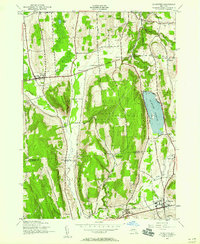
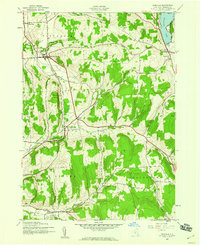
 1943 Cazenovia1958 Print · USGSMadison County at the height of the 1940s reveals a landscape of thriving crossroads and lakeside life. Genealogists and historians can trace family-named sites like Abell Corners, local landmarks like Copstine Bridge, and the historic Welsh Ch.4 unique versions available
 - 1943 Map of Erieville, 1960 Print
 1943 Erieville1960 Print · USGSMadison County's rural landscapes and railroad villages are frozen in time during the early 1940s. Genealogists can trace family roots through landmarks like Quaker Settlement, Allard Cem, and the old depot at Delphi Sta.2 unique versions available
 - 1944 Map of Erieville
 1944 Erieville1944 Print · USGSMadison County's rolling hills and rail-dependent hamlets are captured here during the 1940s. Genealogists and local historians can trace the Lehigh Valley line through Delphi Station or locate family roots near Quaker Settlement and Allard Cem.
 - 1944 Map of Cazenovia
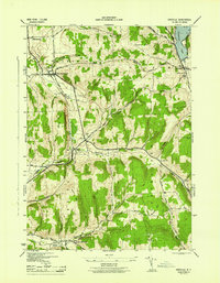
 1944 Cazenovia1944 Print · USGSMadison County's rolling farmland and lakefront properties are meticulously captured in the mid-1940s. Genealogists and historians can trace family locations at Rowan Corners, locate rural burial sites like Ballou Cem, and explore the grounds of Chittenango Falls State Park.
 - 1944 Map of De Ruyter
 1944 De Ruyter1944 Print · USGSCentral New York during the mid-forties reveals a rural landscape shaped by upland ridges and the Lehigh Valley RR. Genealogists can locate family names at Burdick Cem and trace district schoolhouses from Cowles Settlement to Vincent Corners.
 - 1946 Map of Canastota
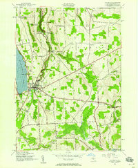
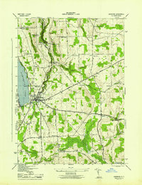
 1946 Canastota1946 Print · USGSMadison County at the close of the war reveals a landscape shaped by three generations of canal and rail transit. Genealogists and local historians can trace the paths of the Old Erie (Abandoned) Canal and the Lehigh Valley railroad near Chittenango and Perryville.2 unique versions available
 - 1948 Map of Binghamton, 1980 Print
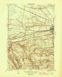
 1948 Binghamton1980 Print · USGSCentral New York and the Southern Tier thrive in the late 1940s as a hub of rail traffic and mountain industry. Researchers can trace historic transit lines like the Erie Railroad through Binghamton or find old valley settlements near Oneonta and Delhi.
End of results
Showing maps 1-11 of 11
Top cities near Cazenovia
- Syracuse historical maps
- Manlius historical maps
- Cicero historical maps
- DeWitt historical maps
- De Witt historical maps
- Sullivan historical maps
See more
Top neighborhoods of Cazenovia
- Union historical maps
- Abell Corners historical maps
- Ballina historical maps
- North Cazenovia historical maps
- Rippleton historical maps
- New Woodstock historical maps
See more
Frequently asked questions
- What are the different types of historical maps available for Cazenovia?
- What is the oldest map of Cazenovia?
- Where can I purchase historical maps of Cazenovia for my home or office?
- Where can I download high-res historical maps of Cazenovia?
- Are there historical topographic maps available for Cazenovia?
- Is there historical aerial imagery available for Cazenovia?
- Where are historical maps of Cazenovia sourced from?