1960s Maps of Lockport, New York
Explore 7 historic maps of Lockport from the 1960s. These maps offer a rare glimpse into what life looked like during the 1960s — showing old roads, neighborhoods, homes, and landmarks that have changed or disappeared over time.
Whether you're researching your family's past, planning a metal detecting trip, or studying how Lockport's landscape evolved across the 1960s, these high-resolution maps are a powerful tool for exploring the history of this region.
- Focus on a specific era: All maps on this page are from the 1960s, giving you a focused view of this time period.
- See what’s changed: Compare century-old streets, trails, and buildings to today's modern landscape using overlays and satellite layers.
- Research with precision: Use these maps for genealogy, historical research, land use analysis, or educational projects.
- View, download, or print: Maps are fully viewable online in high resolution, and can be downloaded or printed for your own records.
Start exploring Lockport's history through authentic maps from the 1960s. This is your window into the past.
Lockport, NY maps
(7)- 1962 Map of Toronto, 1982 Print
 1962 Toronto1982 Print · USGSThe Golden Horseshoe and the Niagara Frontier meet in this early 1960s study of a growing international border region. Trace the path of the Welland Canal and locate land marks like the Scarborough Bluffs and Tuscarora Indian Reservation.
 - 1965 Map of Toronto
 1965 Toronto1965 Print · USGSThe Golden Horseshoe and Niagara Frontier are shown in detail during the early sixties, highlighting the international shipping and transit networks. Trace the path of the Erie Canal, the Welland Canal, and rail lines connecting Toronto and Niagara Falls.2 unique versions available
 - 1965 Map of Gasport, 1967 Print
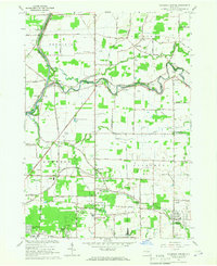
 1965 Gasport1967 Print · USGSNiagara County's agricultural and canal-side life is captured here in the mid-sixties, from the banks of the Erie Canal to the hamlets of Hartland and Royalton Center. Genealogists and historians can locate family landmarks like the Orangeport Ch, Chestnut Ridge Cem, and the old Quarries.
 - 1965 Map of Clarence Center, 1967 Print
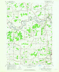
 1965 Clarence Center1967 Print · USGSThe Niagara and Erie county line comes alive in the mid-1960s, showing the early suburban growth of townships like Amherst and Clarence. Genealogists and local historians can trace family roots through St Marys Cem or locate the historic Sulphur Springs Guard Lock along the Erie Canal.
 - 1965 Map of Wolcottsville, 1967 Print
 1965 Wolcottsville1967 Print · USGSThe rural borderlands between Erie and Niagara Counties are captured here in the mid-1960s as a network of small hamlets and agricultural crossroads. Researchers can trace family ties through St Michaels Ch, locate the Elridge Cem, or follow the old New York Central Railroad through Akron Junction.
 - 1965 Map of Cambria, 1968 Print
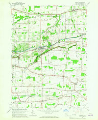
 1965 Cambria1968 Print · USGSNiagara County farmland and crossroads settlements are captured here during the mid-1960s. Genealogists and researchers can trace family landmarks like Budd Cem and the extensive operations at the Lockport Air Force Station.
 - 1965 Map of Lockport, 1968 Print
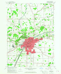 1965 Lockport1968 Print · USGSNiagara County's industrial and civic heart is captured here during the mid-sixties, centered on the historic Erie Canal. Researchers can trace old family names at Stahler Cem, locate the IOOF Home, or study the rail corridors of the Erie-Lackawanna.
End of results
Showing maps 1-7 of 7
Top cities near Lockport
- Buffalo historical maps
- Amherst historical maps
- Cheektowaga historical maps
- Tonawanda historical maps
- Lancaster historical maps
- Clarence historical maps
See more
Top neighborhoods of Lockport
- Carlisle Gardens historical maps
- Nottingham Estates historical maps
- Raymond historical maps
- Ridgelea Heights historical maps
- Hickory Corners historical maps
- Highland Park historical maps
See more
Frequently asked questions
- What are the different types of historical maps available for Lockport?
- What is the oldest map of Lockport?
- Where can I purchase historical maps of Lockport for my home or office?
- Where can I download high-res historical maps of Lockport?
- Are there historical topographic maps available for Lockport?
- Is there historical aerial imagery available for Lockport?
- Where are historical maps of Lockport sourced from?