1980s Maps of Newfane, New York
Explore 3 historic maps of Newfane from the 1980s. These maps offer a rare glimpse into what life looked like during the 1980s — showing old roads, neighborhoods, homes, and landmarks that have changed or disappeared over time.
Whether you're researching your family's past, planning a metal detecting trip, or studying how Newfane's landscape evolved across the 1980s, these high-resolution maps are a powerful tool for exploring the history of this region.
- Focus on a specific era: All maps on this page are from the 1980s, giving you a focused view of this time period.
- See what’s changed: Compare century-old streets, trails, and buildings to today's modern landscape using overlays and satellite layers.
- Research with precision: Use these maps for genealogy, historical research, land use analysis, or educational projects.
- View, download, or print: Maps are fully viewable online in high resolution, and can be downloaded or printed for your own records.
Start exploring Newfane's history through authentic maps from the 1980s. This is your window into the past.
Newfane, NY maps
(3)- 1980 Map of Cambria
 1980 Cambria1980 Print · USGSNiagara County in the early eighties shows a mix of Cold War military presence and educational growth. Researchers can trace the layout of the Lockport Air Force Station, find St Peters Ch, or explore the CONRAIL rail corridor.
 - 1980 Map of Lockport
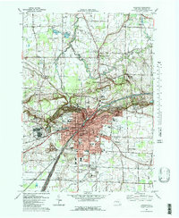 1980 Lockport1980 Print · USGSLockport and the surrounding Niagara County countryside are captured here in the early eighties, showing the city's industrial core and rural townships. Researchers can trace local landmarks like St Bridgets Ch, the County Fairgrounds, and the path of the ERIE CANAL.3 unique versions available
 - 1984 Map of Lockport, 1985 Print
 1984 Lockport1985 Print · USGSWestern New York in the 1980s shows a landscape of lakefront parks, industrial rail corridors, and vast protected wetlands. Genealogists and historians can trace the legacy of local families through sites like Acacia Park Cem or the Tuscarora Indian Reservation.2 unique versions available
End of results
Showing maps 1-3 of 3
Top cities near Newfane
- Amherst historical maps
- Clarence historical maps
- North Tonawanda historical maps
- Grand Island historical maps
- Lockport historical maps
- Lockport historical maps
See more
Top neighborhoods of Newfane
- Burt historical maps
- Corwin historical maps
- Ridgewood historical maps
- Wrights Corners historical maps
- Appleton historical maps
- Newfane historical maps
See more
Frequently asked questions
- What are the different types of historical maps available for Newfane?
- What is the oldest map of Newfane?
- Where can I purchase historical maps of Newfane for my home or office?
- Where can I download high-res historical maps of Newfane?
- Are there historical topographic maps available for Newfane?
- Is there historical aerial imagery available for Newfane?
- Where are historical maps of Newfane sourced from?