1950s Maps of Cicero, New York
Explore 9 historic maps of Cicero from the 1950s. These maps offer a rare glimpse into what life looked like during the 1950s — showing old roads, neighborhoods, homes, and landmarks that have changed or disappeared over time.
Whether you're researching your family's past, planning a metal detecting trip, or studying how Cicero's landscape evolved across the 1950s, these high-resolution maps are a powerful tool for exploring the history of this region.
- Focus on a specific era: All maps on this page are from the 1950s, giving you a focused view of this time period.
- See what’s changed: Compare century-old streets, trails, and buildings to today's modern landscape using overlays and satellite layers.
- Research with precision: Use these maps for genealogy, historical research, land use analysis, or educational projects.
- View, download, or print: Maps are fully viewable online in high resolution, and can be downloaded or printed for your own records.
Start exploring Cicero's history through authentic maps from the 1950s. This is your window into the past.
Cicero, NY maps
(9)- 1950 Map of Utica, 1951 Print
 1950 Utica1951 Print · USGSCentral New York in the post-war era showcases the industrial Mohawk Valley and the pristine Adirondack interior. Researchers can trace transportation networks like the New York Central Railroad and find early Cold War sites such as Griffiss Air Force Base.
 - 1951 Map of Cleveland
 1951 Cleveland1951 Print · USGSOneida Lake and its northern shoreline villages are captured here in the early fifties, showing the region's transition into a modern transportation hub. Genealogists and local historians can trace the foundations of Cleveland, Bridgeport, and Constantia, alongside landmarks like Dakin Bay Sch and the Barge Canal Route.
 - 1957 Map of Utica
 1957 Utica1957 Print · USGSCentral New York and the Adirondack foothills are captured here in the mid-fifties, showing a landscape defined by the Mohawk River corridor and the growing highway system. Genealogists and researchers can trace the rail lines of the New York Central and locate communities from Lowville to Gloversville.
 - 1957 Map of Cleveland, 1959 Print
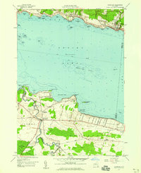 1957 Cleveland1959 Print · USGSOneida Lake’s southern and northern shores are captured in the late 1950s, showing the established communities of Cleveland and Bridgeport. Genealogists can trace family footprints near St Marys Ch, Bridgeport Central Sch, and the Cornell Univ Biological Field Sta.2 unique versions available
 - 1957 Map of Cicero, 1959 Print
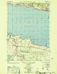
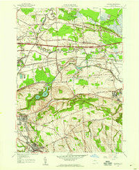
 1957 Cicero1959 Print · USGSNorthern Onondaga County enters a period of rapid suburban growth in the late fifties as residential streets expand toward the lake. Researchers can trace family sites from North Syracuse to the rural Cicero Center, including the Cicero Center Cem and Thompson Rd Ch.2 unique versions available
 - 1957 Map of Syracuse East, 1959 Print
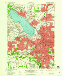
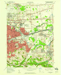 1957 Syracuse East1959 Print · USGSThe Syracuse suburbs and industrial corridors are captured during the peak of mid-century growth. Trace the rail-and-canal economy from the DeWitt Yards to the Erie Canal, alongside Syracuse University and the emerging Carrier Circle.4 unique versions available
 - 1957 Map of Manlius, 1959 Print
 1957 Manlius1959 Print · USGSCentral New York is captured here during the mid-century suburban expansion across the Onondaga and Madison county line. You can trace the remnants of the Old Erie Canal alongside the New York State Thruway and find vanished local landmarks like Bennett Airport and Fyler Settlement.2 unique versions available
 - 1957 Map of Brewerton, 1959 Print
 1957 Brewerton1959 Print · USGSCentral New York's river-and-canal landscape is captured here in the late fifties, showing the expanding settlements of Clay and North Syracuse. Researchers can trace old property boundaries and local landmarks like the Pine Plains Cem, Hayes Airfield, and the New York Central rail line.2 unique versions available
 - 1958 Map of Syracuse West, 1960 Print
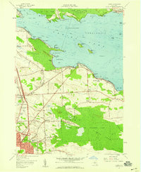
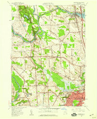
 1958 Syracuse West1960 Print · USGSSyracuse and Onondaga Lake are seen here in the late fifties as suburban expansion reached communities like Fairmount and Mattydale. Researchers can trace the industrial footprint of Solvay, locate old family plots at Loomis Hill Cem, or find the Salt Museum and historic Fort Ste Marie De Ganidentaha.2 unique versions available
End of results
Showing maps 1-9 of 9
Top cities near Cicero
- Syracuse historical maps
- Clay historical maps
- Manlius historical maps
- Salina historical maps
- DeWitt historical maps
- De Witt historical maps
See more
Top neighborhoods of Cicero
- Cicero Center historical maps
- Sandy Bay historical maps
- Forest Beach historical maps
- Lower South Bay historical maps
- Brown Center historical maps
- Kraus Landing historical maps
Frequently asked questions
- What are the different types of historical maps available for Cicero?
- What is the oldest map of Cicero?
- Where can I purchase historical maps of Cicero for my home or office?
- Where can I download high-res historical maps of Cicero?
- Are there historical topographic maps available for Cicero?
- Is there historical aerial imagery available for Cicero?
- Where are historical maps of Cicero sourced from?